


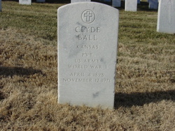
Estella Esther “Stella” Pickering Ball
| Birth | : | 31 Mar 1903 Burlington, Coffey County, Kansas, USA |
| Death | : | 25 Feb 1974 Orange Park, Clay County, Florida, USA |
| Burial | : | Haywood Cemetery, Stone County, USA |
| Coordinate | : | 35.7532997, -91.9032974 |
| Plot | : | Section P, site 64 |
| Inscription | : | His wife |
frequently asked questions (FAQ):
-
Where is Estella Esther “Stella” Pickering Ball's memorial?
Estella Esther “Stella” Pickering Ball's memorial is located at: Haywood Cemetery, Stone County, USA.
-
When did Estella Esther “Stella” Pickering Ball death?
Estella Esther “Stella” Pickering Ball death on 25 Feb 1974 in Orange Park, Clay County, Florida, USA
-
Where are the coordinates of the Estella Esther “Stella” Pickering Ball's memorial?
Latitude: 35.7532997
Longitude: -91.9032974
Family Members:
Parent

Spouse
Siblings
Children
Flowers:


Nearby Cemetories:
1. Haywood Cemetery
Stone County, USA
Coordinate: 35.7532997, -91.9032974
2. York Cemetery
Marcella, Stone County, USA
Coordinate: 35.7619019, -91.8707962
3. Hess Cemetery
Marcella, Stone County, USA
Coordinate: 35.7940770, -91.8774600
4. Bellmore Cemetery
Stone County, USA
Coordinate: 35.7447014, -91.8469009
5. Marcella Cemetery
Marcella, Stone County, USA
Coordinate: 35.7983250, -91.8840661
6. Chalybeate Springs Cemetery
Mountain View, Stone County, USA
Coordinate: 35.7799080, -91.9643420
7. Pleasant Grove Cemetery
Pleasant Grove, Stone County, USA
Coordinate: 35.8156630, -91.9151530
8. Friendship North Cemetery
Fivemile, Cleburne County, USA
Coordinate: 35.6956040, -91.9674150
9. Saint James Cemetery
Saint James, Stone County, USA
Coordinate: 35.8353650, -91.9174830
10. Kelly and Ford Cemetery
Stone County, USA
Coordinate: 35.8418999, -91.9135971
11. Campground Cemetery
Bethesda, Independence County, USA
Coordinate: 35.7881012, -91.8013992
12. Macedonia Cemetery
Drasco, Cleburne County, USA
Coordinate: 35.6747017, -91.9567032
13. Signal Hill Cemetery
Mountain View, Stone County, USA
Coordinate: 35.7386530, -92.0231460
14. Norick Chapel Cemetery
Stone County, USA
Coordinate: 35.7860670, -92.0196710
15. Concord Cemetery
Concord, Cleburne County, USA
Coordinate: 35.6620000, -91.8489000
16. Lindsey Cemetery
Saint James, Stone County, USA
Coordinate: 35.8527985, -91.8739014
17. Oak Grove Cemetery
Wolf Bayou, Cleburne County, USA
Coordinate: 35.6511002, -91.9156036
18. White Cemetery
Cleburne County, USA
Coordinate: 35.6458015, -91.8925018
19. Mount Joy Cemetery
Mountain View, Stone County, USA
Coordinate: 35.8499985, -91.9669037
20. Blair Cemetery
Independence County, USA
Coordinate: 35.8050003, -91.7829971
21. Harris Family Cemetery
Drasco, Cleburne County, USA
Coordinate: 35.6442000, -91.9303000
22. Alexander Cemetery
Cleburne County, USA
Coordinate: 35.6814003, -91.7928009
23. Pilgrims Rest Cemetery
Bethesda, Independence County, USA
Coordinate: 35.7910995, -91.7680969
24. Hollandsworth Cemetery
Stone County, USA
Coordinate: 35.8701340, -91.8566890