
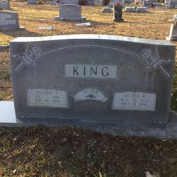
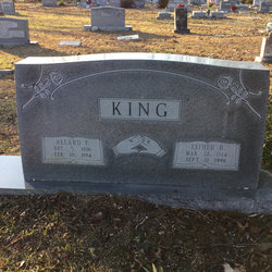
Esther B. Brown King
| Birth | : | 14 Mar 1914 Conway, Horry County, South Carolina, USA |
| Death | : | 11 Sep 1996 Conway, Horry County, South Carolina, USA |
| Burial | : | White Cloud Cemetery, White Cloud, Newaygo County, USA |
| Coordinate | : | 43.5527992, -85.7917023 |
| Description | : | Esther B. King CONWAY -- Esther Brown King, 83, of Kings Road died Wednesday, Sept. 11, 1996, at Kingston Nursing Center after an illness. She was born in Conway, a daughter of the late William and Missouri Johnson Brown. She was the widow of Allard King. Mrs. King was a member of Sweetwater Branch Baptist Church. Survivors include four sons, Howard King of Conway, and Billy Joe King, Johnny King and Donald King, all of Socastee; two daughters, Dorothy Anderson and Mary Dusenbury , both of Myrtle Beach; two stepsons, Thurman King and A.F. King Jr., both of Conway; two stepdaughters, Mazie Brown and Estelle... Read More |
frequently asked questions (FAQ):
-
Where is Esther B. Brown King's memorial?
Esther B. Brown King's memorial is located at: White Cloud Cemetery, White Cloud, Newaygo County, USA.
-
When did Esther B. Brown King death?
Esther B. Brown King death on 11 Sep 1996 in Conway, Horry County, South Carolina, USA
-
Where are the coordinates of the Esther B. Brown King's memorial?
Latitude: 43.5527992
Longitude: -85.7917023
Family Members:
Parent
Spouse
Siblings
Children

Flowers:


Nearby Cemetories:
1. White Cloud Cemetery
White Cloud, Newaygo County, USA
Coordinate: 43.5527992, -85.7917023
2. Saint Joseph Cemetery
White Cloud, Newaygo County, USA
Coordinate: 43.5501671, -85.7900925
3. Amish Cemetery
White Cloud, Newaygo County, USA
Coordinate: 43.5731010, -85.7217026
4. Paulsen Family Cemetery
White Cloud, Newaygo County, USA
Coordinate: 43.5767059, -85.7205392
5. Sherman Township Cemetery
Fremont, Newaygo County, USA
Coordinate: 43.5195630, -85.8704930
6. Lincoln Township Cemetery
Newaygo, Newaygo County, USA
Coordinate: 43.5972400, -85.8792200
7. Big Prairie-Everett Cemetery
Big Prairie, Newaygo County, USA
Coordinate: 43.5200005, -85.6836014
8. Newaygo County Poor Farm Cemetery
Fremont, Newaygo County, USA
Coordinate: 43.4672220, -85.9133330
9. Saint Marys Catholic Cemetery
Croton, Newaygo County, USA
Coordinate: 43.4677780, -85.6633330
10. Hillers Cemetery
Merrill Township, Newaygo County, USA
Coordinate: 43.6789017, -85.8161011
11. Newaygo Cemetery
Newaygo, Newaygo County, USA
Coordinate: 43.4247220, -85.7927780
12. Saint Bartholomew Catholic Cemetery
Newaygo, Newaygo County, USA
Coordinate: 43.4238610, -85.8101750
13. Goodwell Cemetery
Goodwell Township, Newaygo County, USA
Coordinate: 43.5992012, -85.6235962
14. Pioneer Cemetery
Fremont, Newaygo County, USA
Coordinate: 43.4667710, -85.9300380
15. Bull Cemetery
Newaygo, Newaygo County, USA
Coordinate: 43.5541992, -85.9796982
16. Garfield Township Cemetery
Newaygo, Newaygo County, USA
Coordinate: 43.4257400, -85.8601410
17. Fremont United Methodist Church Memorial Garden
Fremont, Newaygo County, USA
Coordinate: 43.4629240, -85.9377360
18. Merrill Township Cemetery
Brohman, Newaygo County, USA
Coordinate: 43.6650000, -85.6770000
19. Croton Township Cemetery
Croton, Newaygo County, USA
Coordinate: 43.4394700, -85.6783800
20. Woodville Cemetery
Woodville, Newaygo County, USA
Coordinate: 43.6677780, -85.6808330
21. Maple Grove Cemetery
Fremont, Newaygo County, USA
Coordinate: 43.4597200, -85.9450000
22. Gowell and Huber Cemetery
Hesperia, Newaygo County, USA
Coordinate: 43.6133330, -85.9991670
23. Mount Calvary Cemetery
Fremont, Newaygo County, USA
Coordinate: 43.4555600, -85.9747200
24. Culp Cemetery
Croton Township, Newaygo County, USA
Coordinate: 43.4537900, -85.6078400