
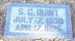
| Birth | : | 8 Jul 1832 Bingham, Somerset County, Maine, USA |
| Death | : | 11 Jun 1909 Carroll, Carroll County, Iowa, USA |
| Burial | : | Carroll City Cemetery, Carroll, Carroll County, USA |
| Coordinate | : | 42.0560963, -94.8599856 |
| Plot | : | Block 2, Lot 188, Space 5 |
| Description | : | Esther was the daughter of John Clark Quint and Abigail Bickford. She married Edgar Atwood on July 22, 1855 at Buchanon, Berrien Co, MI. They were the parents of 6 children, 3 dying in infancy: M.F., Alden, Avrill P (Ada Stone), and Eldis Jay. June 15, 1909 - Carroll Sentinel - The funeral of Mrs Edgar Atwood was held last Sunday and the services were conducted by Rev. J.W. Taylor of the Methodist church. The services were held at the residence in the second ward after which the remains were laid to rest in the city cemetery. The deceased has... Read More |
frequently asked questions (FAQ):
-
Where is Esther Densmore Quint Atwood's memorial?
Esther Densmore Quint Atwood's memorial is located at: Carroll City Cemetery, Carroll, Carroll County, USA.
-
When did Esther Densmore Quint Atwood death?
Esther Densmore Quint Atwood death on 11 Jun 1909 in Carroll, Carroll County, Iowa, USA
-
Where are the coordinates of the Esther Densmore Quint Atwood's memorial?
Latitude: 42.0560963
Longitude: -94.8599856
Family Members:
Parent

Spouse
Siblings
Children
Flowers:


Nearby Cemetories:
1. Carroll City Cemetery
Carroll, Carroll County, USA
Coordinate: 42.0560963, -94.8599856
2. Mount Olivet Cemetery
Carroll, Carroll County, USA
Coordinate: 42.0536340, -94.8595510
3. Holy Angels Cemetery
Carroll County, USA
Coordinate: 42.0014000, -94.9141998
4. Saint Francis Cemetery
Maple River, Carroll County, USA
Coordinate: 42.0969009, -94.9372025
5. Saint Marys Catholic Cemetery
Willey, Carroll County, USA
Coordinate: 41.9783363, -94.8212204
6. Holy Family Cemetery
Lidderdale, Carroll County, USA
Coordinate: 42.1178017, -94.7839966
7. West Lawn Cemetery
Glidden, Carroll County, USA
Coordinate: 42.0649986, -94.7406006
8. Immanuel Cemetery
Lidderdale, Carroll County, USA
Coordinate: 42.1389008, -94.8022003
9. Saint Augustine Cemetery
Halbur, Carroll County, USA
Coordinate: 42.0066986, -94.9744034
10. Our Lady Of Mount Carmel Cemetery
Mount Carmel, Carroll County, USA
Coordinate: 42.1547012, -94.9088974
11. Arcadia Cemetery
Arcadia Township, Carroll County, USA
Coordinate: 42.1000680, -95.0130550
12. East Liberty Cemetery
Lidderdale, Carroll County, USA
Coordinate: 42.1591988, -94.7636032
13. Saint Johns Catholic Cemetery
Arcadia, Carroll County, USA
Coordinate: 42.0855406, -95.0341577
14. Dickson Cemetery
Glidden Township, Carroll County, USA
Coordinate: 42.1074982, -94.6939011
15. McCurdy Cemetery
Carroll County, USA
Coordinate: 41.9403000, -94.7649994
16. Saint Bernards Cemetery
Breda, Carroll County, USA
Coordinate: 42.1786003, -94.9732971
17. Elba Cemetery
Templeton, Carroll County, USA
Coordinate: 41.9068985, -94.9131012
18. Sacred Heart Cemetery
Templeton, Carroll County, USA
Coordinate: 41.9138746, -94.9460994
19. North Coon Cemetery
Carroll County, USA
Coordinate: 42.1260986, -94.6716995
20. Dedham Cemetery
Dedham, Carroll County, USA
Coordinate: 41.8993988, -94.8225021
21. Saint Josephs Cemetery
Dedham, Carroll County, USA
Coordinate: 41.8993988, -94.8210983
22. Old Carrollton Cemetery
Carrollton, Carroll County, USA
Coordinate: 41.9233017, -94.7403030
23. Lanesboro Cemetery
Lanesboro, Carroll County, USA
Coordinate: 42.1810989, -94.7230988
24. Luckow Cemetery
Auburn, Sac County, USA
Coordinate: 42.2168999, -94.9266968