

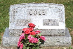
Esther L Fuelling Cole
| Birth | : | 1917 Portland, Jay County, Indiana, USA |
| Death | : | 23 Mar 1953 Noble County, Indiana, USA |
| Burial | : | Atereth Israel Cemetery, West Roxbury, Suffolk County, USA |
| Coordinate | : | 42.2888900, -71.1825800 |
| Plot | : | H4 |
| Description | : | Cole Esther, about 36, died March 23, 1853 at her home about two miles west of Albion after suffering a heart attack. She was born at Portland, Ind. Surviving are her husband, Ray; their son, Richard; and two daughters, Martha Jane and Helen Louise, all at home; her mother, Mrs. Martha Ann Fuelling; and a brother, Louis Fuelling of Portland. She was an active member of the Albion Presbyterian Church, the Ladies Circle, and the Home Economics Club. Funeral Wednesday at the Presbyterian Church. Burial, Rose Hill Cemetery. + |
frequently asked questions (FAQ):
-
Where is Esther L Fuelling Cole's memorial?
Esther L Fuelling Cole's memorial is located at: Atereth Israel Cemetery, West Roxbury, Suffolk County, USA.
-
When did Esther L Fuelling Cole death?
Esther L Fuelling Cole death on 23 Mar 1953 in Noble County, Indiana, USA
-
Where are the coordinates of the Esther L Fuelling Cole's memorial?
Latitude: 42.2888900
Longitude: -71.1825800
Family Members:
Flowers:


Nearby Cemetories:
1. Atereth Israel Cemetery
West Roxbury, Suffolk County, USA
Coordinate: 42.2888900, -71.1825800
2. Pultusker Cemetery
West Roxbury, Suffolk County, USA
Coordinate: 42.2887900, -71.1826600
3. Polonnoe Cemetery
West Roxbury, Suffolk County, USA
Coordinate: 42.2889800, -71.1824700
4. Shepetovka Cemetery
West Roxbury, Suffolk County, USA
Coordinate: 42.2888800, -71.1828000
5. Zviller Cemetery
West Roxbury, Suffolk County, USA
Coordinate: 42.2890800, -71.1825900
6. Lord Rothschild Cemetery
West Roxbury, Suffolk County, USA
Coordinate: 42.2887000, -71.1827500
7. Kehillath Jacob Cemetery
West Roxbury, Suffolk County, USA
Coordinate: 42.2891200, -71.1823200
8. David Vicur Cholim Cemetery
West Roxbury, Suffolk County, USA
Coordinate: 42.2892900, -71.1823700
9. Ostro Marsho Cemetery
West Roxbury, Suffolk County, USA
Coordinate: 42.2885200, -71.1829000
10. Kaminker Cemetery
West Roxbury, Suffolk County, USA
Coordinate: 42.2885900, -71.1830800
11. Independent Pride of Boston Cemetery
West Roxbury, Suffolk County, USA
Coordinate: 42.2893200, -71.1820900
12. Hebrew Volin Cemetery
West Roxbury, Suffolk County, USA
Coordinate: 42.2884300, -71.1832200
13. Boylston Lodge Cemetery
West Roxbury, Suffolk County, USA
Coordinate: 42.2882400, -71.1831700
14. Koretzer Cemetery
West Roxbury, Suffolk County, USA
Coordinate: 42.2895100, -71.1818600
15. Custom Tailors Cemetery
West Roxbury, Suffolk County, USA
Coordinate: 42.2882600, -71.1834700
16. Independent Workmens Circle Cemetery
West Roxbury, Suffolk County, USA
Coordinate: 42.2896800, -71.1818600
17. Quincy Hebrew Cemetery
West Roxbury, Suffolk County, USA
Coordinate: 42.2897300, -71.1816000
18. Kovner Cemetery
West Roxbury, Suffolk County, USA
Coordinate: 42.2880000, -71.1835400
19. Staro Konstantinov Cemetery
West Roxbury, Suffolk County, USA
Coordinate: 42.2897900, -71.1815200
20. Stepiner Cemetery
West Roxbury, Suffolk County, USA
Coordinate: 42.2880300, -71.1838000
21. Olita Cemetery
West Roxbury, Suffolk County, USA
Coordinate: 42.2878900, -71.1836900
22. Anshei Sfard Cemetery
West Roxbury, Suffolk County, USA
Coordinate: 42.2900400, -71.1814300
23. Abramson Cemetery
West Roxbury, Suffolk County, USA
Coordinate: 42.2877700, -71.1838500
24. American Friendship Cemetery
West Roxbury, Suffolk County, USA
Coordinate: 42.2876500, -71.1839700