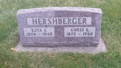
Esther L. Miller Hershberger
| Birth | : | 15 Dec 1874 Johnson County, Iowa, USA |
| Death | : | 1 May 1948 Kalona, Washington County, Iowa, USA |
| Burial | : | Wells Cemetery, Canaan, Grafton County, USA |
| Coordinate | : | 43.6563200, -72.0253800 |
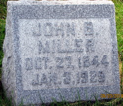
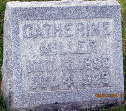
| Description | : | HERSHBERGER. - Esther L., daughter of John B. and Catherine (Yoder) Miller, was born near Amish Post Office, Johnson Co., Iowa, Dec. 15, 1874; died at her home, in Kalona, Iowa, June 1, 1948; aged 73 y. 5 m. 16 d. at the age of sixteen she accepted Christ as her Saviour, was baptized and became a member of the Lower Deer Creek Mennonite Church, Kalona, Iowa. On Nov. 18, 1894, she was united in marriage to Chris E. Hershberger. They lived in the vicinity of Kalona and Wellman, Iowa, all their married life, except during the years 1911-1919, when... Read More |
frequently asked questions (FAQ):
-
Where is Esther L. Miller Hershberger's memorial?
Esther L. Miller Hershberger's memorial is located at: Wells Cemetery, Canaan, Grafton County, USA.
-
When did Esther L. Miller Hershberger death?
Esther L. Miller Hershberger death on 1 May 1948 in Kalona, Washington County, Iowa, USA
-
Where are the coordinates of the Esther L. Miller Hershberger's memorial?
Latitude: 43.6563200
Longitude: -72.0253800
Family Members:
Parent
Spouse
Siblings
Children
Flowers:
Nearby Cemetories:
1. Wells Cemetery
Canaan, Grafton County, USA
Coordinate: 43.6563200, -72.0253800
2. Canaan Street Cemetery
Canaan, Grafton County, USA
Coordinate: 43.6736200, -72.0470100
3. Cobble Hill Cemetery
Canaan, Grafton County, USA
Coordinate: 43.6327780, -72.0416670
4. French Cemetery
Orange, Grafton County, USA
Coordinate: 43.6544200, -71.9685600
5. Church Cemetery
Orange, Grafton County, USA
Coordinate: 43.6555100, -71.9659600
6. Scofield Cemetery
Canaan, Grafton County, USA
Coordinate: 43.6319440, -72.0777780
7. Porter Family Cemetery
Canaan Center, Grafton County, USA
Coordinate: 43.6966880, -72.0586400
8. Saint Marys Cemetery
Canaan, Grafton County, USA
Coordinate: 43.7038890, -72.0164270
9. West Canaan Cemetery
West Canaan, Grafton County, USA
Coordinate: 43.6455700, -72.0911800
10. Orange Common Cemetery
Orange, Grafton County, USA
Coordinate: 43.6535988, -71.9543991
11. Morse Cemetery
Enfield, Grafton County, USA
Coordinate: 43.6060400, -72.0539100
12. Sawyer Hill Cemetery
Canaan, Grafton County, USA
Coordinate: 43.7020200, -72.0682000
13. Birch Corners Cemetery
Canaan, Grafton County, USA
Coordinate: 43.6994100, -71.9677300
14. Atwell Cemetery
Canaan, Grafton County, USA
Coordinate: 43.7113890, -71.9869440
15. See it All Cemetery
Dorchester, Grafton County, USA
Coordinate: 43.7154880, -71.9811930
16. Town Cemetery
Enfield, Grafton County, USA
Coordinate: 43.6119170, -72.0972360
17. Lockehaven Cemetery
Enfield, Grafton County, USA
Coordinate: 43.6119440, -72.0977780
18. Country Side Cemetery
Enfield, Grafton County, USA
Coordinate: 43.6147400, -72.1060990
19. Butman Cemetery
Enfield, Grafton County, USA
Coordinate: 43.5952400, -72.0795610
20. Countryside Cemetery
Grafton County, USA
Coordinate: 43.6131927, -72.1065096
21. Old Cemetery
Enfield, Grafton County, USA
Coordinate: 43.6238890, -72.1186110
22. Blake Cemetery
Dorchester, Grafton County, USA
Coordinate: 43.7323570, -72.0120660
23. West Farms Cemetery
Canaan, Grafton County, USA
Coordinate: 43.6869000, -72.1273000
24. Pollard Cemetery
Dorchester, Grafton County, USA
Coordinate: 43.7380700, -72.0527300

