

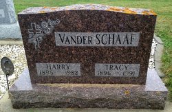
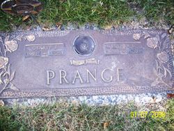
Esther Lillian Vander Schaaf Prange
| Birth | : | 3 Apr 1920 Doon, Lyon County, Iowa, USA |
| Death | : | 15 Aug 2013 Spencer, Clay County, Iowa, USA |
| Burial | : | North Lawn Cemetery, Spencer, Clay County, USA |
| Coordinate | : | 43.1600000, -95.1470000 |
| Description | : | Esther passed away Thursday, August 15, at St. Luke Lutheran Home in Spencer. Esther Lillian Prange was born April 3, 1920, to Harry and Tracy Vander Schaaf on a farm near Doon, Iowa. In 1926, the family moved to Hull. After graduating from public school, she worked in the local cafe. Esther married Gerrit Prange on December 9, 1944. After his discharge, he worked briefly in Spirit Lake, and then was transferred to Sheldon. She was a homemaker during this time. They moved to Spencer in 1954. Since the church was fairly new and small, they were both involved in many activities... Read More |
frequently asked questions (FAQ):
-
Where is Esther Lillian Vander Schaaf Prange's memorial?
Esther Lillian Vander Schaaf Prange's memorial is located at: North Lawn Cemetery, Spencer, Clay County, USA.
-
When did Esther Lillian Vander Schaaf Prange death?
Esther Lillian Vander Schaaf Prange death on 15 Aug 2013 in Spencer, Clay County, Iowa, USA
-
Where are the coordinates of the Esther Lillian Vander Schaaf Prange's memorial?
Latitude: 43.1600000
Longitude: -95.1470000
Family Members:
Parent

Spouse
Siblings
Children
Flowers:


Nearby Cemetories:
1. North Lawn Cemetery
Spencer, Clay County, USA
Coordinate: 43.1600000, -95.1470000
2. Dewey Readmore Books Memorial
Spencer, Clay County, USA
Coordinate: 43.1403999, -95.1443024
3. Riverside Cemetery
Spencer, Clay County, USA
Coordinate: 43.1441994, -95.1671982
4. Fairview Cemetery
Clay County, USA
Coordinate: 43.1899986, -95.0800018
5. Evergreen Cemetery
Clay County, USA
Coordinate: 43.2052994, -95.2086029
6. Dickens Cemetery
Dickens, Clay County, USA
Coordinate: 43.1280000, -95.0155000
7. Swedish Lutheran Cemetery
Royal, Clay County, USA
Coordinate: 43.0683000, -95.2350000
8. Little Sioux Lutheran Cemetery
Milford, Dickinson County, USA
Coordinate: 43.2702065, -95.2109528
9. Rosehill Cemetery
Clay County, USA
Coordinate: 43.0368996, -95.0919037
10. First Reformed Cemetery
Clay County, USA
Coordinate: 43.2399500, -95.2889000
11. Lone Tree Cemetery
Everly, Clay County, USA
Coordinate: 43.1411018, -95.3347015
12. Milford Cemetery
Milford, Dickinson County, USA
Coordinate: 43.3092003, -95.1481018
13. Lincoln Cemetery
Rossie, Clay County, USA
Coordinate: 43.0111008, -95.2313995
14. Calvary Cemetery
Milford, Dickinson County, USA
Coordinate: 43.3213997, -95.1688995
15. Logan Township Cemetery
Clay County, USA
Coordinate: 43.0489006, -94.9747009
16. Liberty Cemetery
Greenville, Clay County, USA
Coordinate: 42.9897003, -95.1417007
17. Willow Creek Cemetery
Royal, Clay County, USA
Coordinate: 43.0214005, -95.2885971
18. Clay Center Cemetery
Royal, Clay County, USA
Coordinate: 43.0410995, -95.3272018
19. TriMello Cemetery
Royal, Clay County, USA
Coordinate: 43.0682983, -95.3728027
20. Crown Hill Cemetery
Ruthven, Palo Alto County, USA
Coordinate: 43.1328011, -94.8878021
21. Calvary Cemetery
Ruthven, Palo Alto County, USA
Coordinate: 43.1314011, -94.8869019
22. Zion Methodist Cemetery
Clay County, USA
Coordinate: 42.9808006, -95.2497025
23. Westport Cemetery
Dickinson County, USA
Coordinate: 43.3130989, -95.3289032
24. Okoboji Cemetery
Arnolds Park, Dickinson County, USA
Coordinate: 43.3649406, -95.1303558