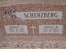
Esther Lucille Marie Heins Scherzberg
| Birth | : | 2 Oct 1915 Sherman County, Nebraska, USA |
| Death | : | 15 Apr 2004 Saint Paul, Howard County, Nebraska, USA |
| Burial | : | Saint Johannes Cemetery, Fredonia, Logan County, USA |
| Coordinate | : | 46.3708000, -99.0994034 |
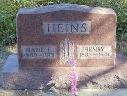
| Description | : | Daughter of Henry & Marie (Mahnke) Heins. Married to Arnold F. Scherzberg on 2-14-1939 |
frequently asked questions (FAQ):
-
Where is Esther Lucille Marie Heins Scherzberg's memorial?
Esther Lucille Marie Heins Scherzberg's memorial is located at: Saint Johannes Cemetery, Fredonia, Logan County, USA.
-
When did Esther Lucille Marie Heins Scherzberg death?
Esther Lucille Marie Heins Scherzberg death on 15 Apr 2004 in Saint Paul, Howard County, Nebraska, USA
-
Where are the coordinates of the Esther Lucille Marie Heins Scherzberg's memorial?
Latitude: 46.3708000
Longitude: -99.0994034
Family Members:
Parent
Spouse
Siblings
Children
Flowers:
Nearby Cemetories:
1. Saint Johannes Cemetery
Fredonia, Logan County, USA
Coordinate: 46.3708000, -99.0994034
2. Fredonia Lutheran Cemetery
Fredonia, Logan County, USA
Coordinate: 46.3703003, -99.0994034
3. Eslinger Family Cemetery
Logan County, USA
Coordinate: 46.3786011, -99.1406021
4. Nazareth Parish Congregational Cemetery
Fredonia, Logan County, USA
Coordinate: 46.3410988, -99.0907974
5. Wolf Cemetery
Logan County, USA
Coordinate: 46.4093140, -99.1414970
6. Pamona Cemetery
Fredonia, Logan County, USA
Coordinate: 46.3258018, -99.0575027
7. Tiede Lutheran Cemetery
Logan County, USA
Coordinate: 46.4397011, -99.0997009
8. Labrensz Cemetery
Logan County, USA
Coordinate: 46.4131012, -99.1838989
9. Friedenthal Cemetery
Logan County, USA
Coordinate: 46.4413986, -99.1292038
10. Frank Findel Burial Site
Fredonia, Logan County, USA
Coordinate: 46.4353490, -99.1735430
11. Finnish Cemetery
Logan County, USA
Coordinate: 46.4418983, -99.1631012
12. Homola Cemetery
Gackle, Logan County, USA
Coordinate: 46.4423800, -99.1631600
13. Tabor Congregation Cemetery
Logan County, USA
Coordinate: 46.3344002, -99.2249985
14. Swede Township Cemetery
LaMoure County, USA
Coordinate: 46.3828011, -98.9533005
15. Assembly of God Cemetery
Kulm, LaMoure County, USA
Coordinate: 46.3117190, -98.9766830
16. Kulm Congregational Cemetery
Kulm, LaMoure County, USA
Coordinate: 46.3114014, -98.9756012
17. Hillside Cemetery
Kulm, LaMoure County, USA
Coordinate: 46.3116600, -98.9744100
18. Lautt Cemetery
Logan County, USA
Coordinate: 46.2844009, -99.2050018
19. Saint James Cemetery
Logan County, USA
Coordinate: 46.4832993, -99.1213989
20. Pomona Valley Lutheran Cemetery
Kulm, LaMoure County, USA
Coordinate: 46.3064003, -98.9443970
21. Emmanuel Congregational Cemetery
Gackle, Logan County, USA
Coordinate: 46.4860900, -99.1937700
22. Postal Cemetery
LaMoure County, USA
Coordinate: 46.5009070, -99.0176750
23. Zion United Methodist Cemetery
Dickey County, USA
Coordinate: 46.2731018, -98.9421997
24. Gnadenfeld Congregational Cemetery
McIntosh County, USA
Coordinate: 46.2282982, -99.0441971

