
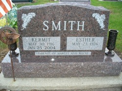

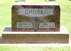
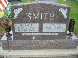
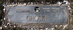
Esther Mae Ghoske Smith
| Birth | : | 23 May 1926 Alden, Hardin County, Iowa, USA |
| Death | : | 9 Jul 2015 Iowa Falls, Hardin County, Iowa, USA |
| Burial | : | Saint Joseph Cemetery, Taunton, Bristol County, USA |
| Coordinate | : | 41.9199982, -71.0792007 |
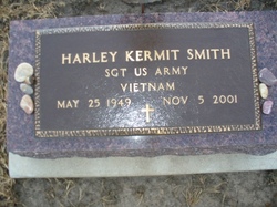
| Inscription | : | Parents of Harley & Wayne |
| Description | : | Esther M. Smith, 89, of Iowa Falls, Iowa passed away Thursday, July 9, 2015, at the Hansen Family Hospital, Iowa Falls. Esther was born May 23, 1926, at her parents farm near Buckeye, Iowa, in Hardin County. She was the daughter of Emil Fredrick Ghoske and Martha Marie [Bieberman] Ghoske. She attended the Buckeye School until it closed her 11th grade year and then went to Alden High where she graduated with the class of 1944. On May 26, 1948 she was united in marriage to Kermit V. Smith at the Methodist Church in Iowa Falls.... Read More |
frequently asked questions (FAQ):
-
Where is Esther Mae Ghoske Smith's memorial?
Esther Mae Ghoske Smith's memorial is located at: Saint Joseph Cemetery, Taunton, Bristol County, USA.
-
When did Esther Mae Ghoske Smith death?
Esther Mae Ghoske Smith death on 9 Jul 2015 in Iowa Falls, Hardin County, Iowa, USA
-
Where are the coordinates of the Esther Mae Ghoske Smith's memorial?
Latitude: 41.9199982
Longitude: -71.0792007
Family Members:
Parent

Spouse
Siblings
Children
Flowers:


Nearby Cemetories:
1. Saint Joseph Cemetery
Taunton, Bristol County, USA
Coordinate: 41.9199982, -71.0792007
2. Mayflower Hill Cemetery
Taunton, Bristol County, USA
Coordinate: 41.9199982, -71.0875015
3. Saint Mary Cemetery
Taunton, Bristol County, USA
Coordinate: 41.9219900, -71.0878900
4. Plain Cemetery
Taunton, Bristol County, USA
Coordinate: 41.9124985, -71.0916977
5. Father Wilson Cemetery
Taunton, Bristol County, USA
Coordinate: 41.9087600, -71.0921900
6. Ox Bow Farm Cemetery
Taunton, Bristol County, USA
Coordinate: 41.9027020, -71.0714260
7. Dean Cemetery
Raynham, Bristol County, USA
Coordinate: 41.9053970, -71.0616490
8. Shaw Cemetery
Raynham, Bristol County, USA
Coordinate: 41.9081400, -71.0550000
9. Neck O Land Cemetery
Taunton, Bristol County, USA
Coordinate: 41.8978500, -71.0850000
10. Pleasant Street Cemetery
Raynham, Bristol County, USA
Coordinate: 41.9277992, -71.0477982
11. Seth Staples Gravesite
Taunton, Bristol County, USA
Coordinate: 41.8954700, -71.0730000
12. Brittun Cemetery
Raynham, Bristol County, USA
Coordinate: 41.9446800, -71.0698100
13. Wetherell Cemetery
Taunton, Bristol County, USA
Coordinate: 41.9449200, -71.0886700
14. Britton Cemetery
Raynham, Bristol County, USA
Coordinate: 41.9440800, -71.0579800
15. Mount Pleasant Cemetery
Taunton, Bristol County, USA
Coordinate: 41.8941500, -71.1009100
16. King Cemetery
Raynham, Bristol County, USA
Coordinate: 41.9019020, -71.0439020
17. Bassett Street Cemetery
Taunton, Bristol County, USA
Coordinate: 41.9395100, -71.1156200
18. Bezer Lincoln Cemetery
Taunton, Bristol County, USA
Coordinate: 41.9429800, -71.1153300
19. Saint Thomas Episcopal Burying Ground
Taunton, Bristol County, USA
Coordinate: 41.9105900, -71.1270100
20. Asa Lincoln Family Gravesite
Taunton, Bristol County, USA
Coordinate: 41.9043950, -71.1240160
21. East Weir Cemetery
Taunton, Bristol County, USA
Coordinate: 41.8827270, -71.0851280
22. Harvey Family Burying Ground
Taunton, Bristol County, USA
Coordinate: 41.9408500, -71.1231300
23. Cooper Burying Ground
Taunton, Bristol County, USA
Coordinate: 41.8792900, -71.0882500
24. Crane Avenue South Thayer Family Burial Ground
Taunton, Bristol County, USA
Coordinate: 41.9288300, -71.1336900