

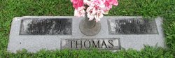
Esther Marie Jones Thomas Sapp
| Birth | : | 19 Sep 1911 Hagers Grove, Shelby County, Missouri, USA |
| Death | : | 16 Jun 1995 Macon, Macon County, Missouri, USA |
| Burial | : | Elmwood Cemetery, DeWitt, Clinton County, USA |
| Coordinate | : | 41.8349991, -90.5366974 |
| Description | : | Esther Jones Sapp Esther Jones Sapp, 83, of Macon, formerly of Hannibal and the New London area, died Friday evening, June 16, 1995, at the Samaritan Memorial Hospital in Macon. Funeral services were held at 1 p.m. Monday at the Hutton & McElwain Funeral Home in Macon, with Rev. Bill Briley officiating. Burial will be in Maplewood Cemetery at Clarence. Mrs. Sapp was born on Sept. 19, 1911, in rural Shelby County, north of Clarence-Hagers Grove area, the daughter of Floyd H. and Hannah Mariah "Dollie" Patton Jones. In May of 1933 she married Raymond M. Thomas and they owned... Read More |
frequently asked questions (FAQ):
-
Where is Esther Marie Jones Thomas Sapp's memorial?
Esther Marie Jones Thomas Sapp's memorial is located at: Elmwood Cemetery, DeWitt, Clinton County, USA.
-
When did Esther Marie Jones Thomas Sapp death?
Esther Marie Jones Thomas Sapp death on 16 Jun 1995 in Macon, Macon County, Missouri, USA
-
Where are the coordinates of the Esther Marie Jones Thomas Sapp's memorial?
Latitude: 41.8349991
Longitude: -90.5366974
Family Members:


Nearby Cemetories:
1. Saint Joseph's Cemetery
DeWitt, Clinton County, USA
Coordinate: 41.8283005, -90.5425034
2. Oak Ridge Cemetery
DeWitt, Clinton County, USA
Coordinate: 41.8283617, -90.5426362
3. Ames Creek Cemetery
DeWitt, Clinton County, USA
Coordinate: 41.8008000, -90.4959000
4. Walrod Family Farm Cemetery
Welton, Clinton County, USA
Coordinate: 41.8805822, -90.5779145
5. Smith Cemetery
Grand Mound, Clinton County, USA
Coordinate: 41.7888985, -90.6069031
6. Pelham Cemetery
Clinton County, USA
Coordinate: 41.8189011, -90.4272003
7. Barber Cemetery
Clinton County, USA
Coordinate: 41.7882000, -90.6296000
8. Saint Patrick's-Villa Nova Cemetery
Clinton County, USA
Coordinate: 41.9000893, -90.4634628
9. Saint Patrick's Cemetery
Charlotte, Clinton County, USA
Coordinate: 41.9016991, -90.4636002
10. Evergreen Cemetery
Grand Mound, Clinton County, USA
Coordinate: 41.8227997, -90.6547012
11. Calvary Cemetery
Grand Mound, Clinton County, USA
Coordinate: 41.8236700, -90.6551000
12. Seventh Day Baptist Cemetery
Welton, Clinton County, USA
Coordinate: 41.9130000, -90.6017000
13. Oakview Cemetery
Welton, Clinton County, USA
Coordinate: 41.9197930, -90.6031520
14. Allison Cemetery
Grand Mound, Clinton County, USA
Coordinate: 41.7742004, -90.6457977
15. McCausland Cemetery
McCausland, Scott County, USA
Coordinate: 41.7478104, -90.4468002
16. Saint Anns Catholic Church Cemetery
Long Grove, Scott County, USA
Coordinate: 41.7279587, -90.5754089
17. Fairview Cemetery
Park View, Scott County, USA
Coordinate: 41.7202988, -90.5093994
18. Cousins Cemetery
Malone, Clinton County, USA
Coordinate: 41.8171000, -90.3790000
19. Rossiter Cemetery
Charlotte, Clinton County, USA
Coordinate: 41.9418983, -90.4618988
20. Clinton County Farm Cemetery
Charlotte, Clinton County, USA
Coordinate: 41.9425011, -90.4614029
21. Prairie Union Cemetery
Low Moor, Clinton County, USA
Coordinate: 41.7797012, -90.3906021
22. Bowers-Dannatt-Hill Cemetery
Low Moor, Clinton County, USA
Coordinate: 41.7942009, -90.3775024
23. Bloomfield Cemetery
Clinton County, USA
Coordinate: 41.9458008, -90.6194000
24. Immaculate Conception Cemetery
Petersville, Clinton County, USA
Coordinate: 41.9663000, -90.5332000