
| Birth | : | 16 Jan 1930 Sheridan County, Kansas, USA |
| Death | : | 11 Sep 2019 Quinter, Gove County, Kansas, USA |
| Burial | : | Saint Michaels Cemetery, Collyer, Trego County, USA |
| Coordinate | : | 39.0318985, -100.1153030 |
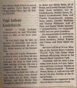
| Description | : | Esther Mader, age 89, of Quinter, KS passed away on Wednesday, September 11, 2019 at Gove County Medical Center Long Term Care, Quinter. Esther was born in rural Sheridan County, Kansas on January 16, 1930 to Alex and Anna (Bollig) Kinderknecht. Esther attended Riverside School where she completed the eighth grade. She was united in marriage to Alvin Mader on April 24, 1950, and they were happily married for 69 years. She was a farmwife on the family farm where she spent her time raising and caring for her children, spending time gardening, and... Read More |
frequently asked questions (FAQ):
-
Where is Esther Marie Kinderknecht Mader's memorial?
Esther Marie Kinderknecht Mader's memorial is located at: Saint Michaels Cemetery, Collyer, Trego County, USA.
-
When did Esther Marie Kinderknecht Mader death?
Esther Marie Kinderknecht Mader death on 11 Sep 2019 in Quinter, Gove County, Kansas, USA
-
Where are the coordinates of the Esther Marie Kinderknecht Mader's memorial?
Latitude: 39.0318985
Longitude: -100.1153030
Family Members:
Parent

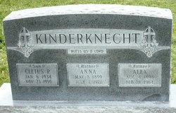
Spouse

Siblings

Flowers:


Nearby Cemetories:
1. Saint Michaels Cemetery
Collyer, Trego County, USA
Coordinate: 39.0318985, -100.1153030
2. Union Cemetery
Collyer, Trego County, USA
Coordinate: 39.0299988, -100.1125031
3. Old Order German Baptist Cemetery
Quinter, Gove County, USA
Coordinate: 39.0299988, -100.2052994
4. Quinter Cemetery
Quinter, Gove County, USA
Coordinate: 39.0736008, -100.2236023
5. Red Top Cemetery
Quinter, Gove County, USA
Coordinate: 38.9449997, -100.2431030
6. Saline Valley Cemetery
Trego County, USA
Coordinate: 39.1180992, -99.9610977
7. Saint Anthony Cemetery
Graham County, USA
Coordinate: 39.1892014, -100.0805969
8. Kansas Veterans Cemetery at Wakeeney
WaKeeney, Trego County, USA
Coordinate: 39.0172200, -99.8715300
9. Christ the King Catholic Cemetery
WaKeeney, Trego County, USA
Coordinate: 39.0166500, -99.8712000
10. Wakeeney City Cemetery
WaKeeney, Trego County, USA
Coordinate: 39.0158005, -99.8711014
11. Sacred Heart Cemetery
Park, Gove County, USA
Coordinate: 39.1147003, -100.3555984
12. Leland Cemetery
Penokee, Graham County, USA
Coordinate: 39.2256012, -100.0149994
13. West Park Cemetery
Gove County, USA
Coordinate: 39.1107100, -100.3688300
14. Bethel Christian Cemetery
Studley, Sheridan County, USA
Coordinate: 39.2334100, -100.2051300
15. Mount Pleasant Community Cemetery
Studley, Sheridan County, USA
Coordinate: 39.2550011, -100.1635971
16. Zion Lutheran Cemetery
Trego Center, Trego County, USA
Coordinate: 38.8782997, -99.8927994
17. Morning Star Cemetery
Gove County, USA
Coordinate: 38.8431015, -100.3349991
18. Prairie Home Cemetery
Graham County, USA
Coordinate: 39.1903000, -99.8566971
19. Grainfield Cemetery
Grainfield, Gove County, USA
Coordinate: 39.1180992, -100.4708023
20. Alanthus Cemetery
Gove County, USA
Coordinate: 38.7731018, -100.2822037
21. Brush Creek Cemetery
Graham County, USA
Coordinate: 39.3011900, -99.9743400
22. Gove Cemetery
Gove, Gove County, USA
Coordinate: 38.9467010, -100.4847031
23. Ogallah Cemetery
Trego County, USA
Coordinate: 38.9925003, -99.7241974
24. Baugher Cemetery
Studley, Sheridan County, USA
Coordinate: 39.3205600, -100.2560800