


Esther P. Hood Zrubek
| Birth | : | 8 Sep 1919 Pawnee County, Nebraska, USA |
| Death | : | 21 Oct 2008 Salina, Saline County, Kansas, USA |
| Burial | : | Miles Cemetery, Miles, Western Downs Region, Australia |
| Coordinate | : | -26.6471130, 150.1914740 |
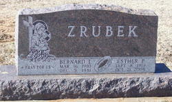
| Inscription | : | Married June 29, 1939 |
| Description | : | Esther P. Zrubek, age 89, died Monday, Oct. 21, 2008, at Windsor Estates Nursing Center, Salina. She was born Sept. 8, 1919, at Pawnee County, NE, to Jesse and Daisy (Cargill) Hood. She was a homemaker. She is preceded in death by her husband, Ben, in 1981; an infant daughter, Debra Sue, in 1954: and her special friend, Steve Brylla, in 1989. She is survived by five sons: Lyle and wife Nancy Zrubek, of Hutchinson; Bob Zrubek, Larry and wife Ethel Zrubek and David and wife Janice Zrubek, all of Salina, and Richard and... Read More |
frequently asked questions (FAQ):
-
Where is Esther P. Hood Zrubek's memorial?
Esther P. Hood Zrubek's memorial is located at: Miles Cemetery, Miles, Western Downs Region, Australia.
-
When did Esther P. Hood Zrubek death?
Esther P. Hood Zrubek death on 21 Oct 2008 in Salina, Saline County, Kansas, USA
-
Where are the coordinates of the Esther P. Hood Zrubek's memorial?
Latitude: -26.6471130
Longitude: 150.1914740
Family Members:
Parent
Spouse
Siblings
Children

Flowers:


Nearby Cemetories:
1. Miles Cemetery
Miles, Western Downs Region, Australia
Coordinate: -26.6471130, 150.1914740
2. Blackley Cemetery
Miles, Western Downs Region, Australia
Coordinate: -26.6490250, 150.1983660
3. Miles Historical Cemetery
Miles, Western Downs Region, Australia
Coordinate: -26.6497710, 150.1998290
4. Dogwood Cemetery
Miles, Western Downs Region, Australia
Coordinate: -26.6607100, 150.1803800
5. Condamine Pioneer Cemetery
Condamine, Western Downs Region, Australia
Coordinate: -26.9395170, 150.1344390
6. Downfall Creek Cemetery
Guluguba, Western Downs Region, Australia
Coordinate: -26.2554980, 150.1493570
7. Chinchilla Pioneer Cemetery
Chinchilla, Western Downs Region, Australia
Coordinate: -26.7398700, 150.6306100
8. Tanderra Lawn Cemetery
Chinchilla, Western Downs Region, Australia
Coordinate: -26.7356500, 150.6482300
9. Chinchilla Monumental Cemetery
Chinchilla, Western Downs Region, Australia
Coordinate: -26.7376900, 150.6477800
10. Jackson Cemetery
Jackson, Maranoa Region, Australia
Coordinate: -26.6475370, 149.6301730
11. Brigalow Historical Cemetery
Brigalow, Western Downs Region, Australia
Coordinate: -26.8080778, 150.8217222
12. Wandoan Cemetery
Wandoan, Western Downs Region, Australia
Coordinate: -26.0785660, 149.9358190
13. Tara General Cemetery
Tara, Western Downs Region, Australia
Coordinate: -27.2743200, 150.4577530
14. The Gums Cemetery
The Gums, Western Downs Region, Australia
Coordinate: -27.3390290, 150.1963350
15. Warra General Cemetery
Warra, Western Downs Region, Australia
Coordinate: -26.9365741, 150.9225926
16. Yuleba Cemetery
Yuleba, Maranoa Region, Australia
Coordinate: -26.6127920, 149.3924750
17. Meandarra Cemetery
Meandarra, Western Downs Region, Australia
Coordinate: -27.3298790, 149.8789200
18. Jandowae Cemetery
Jandowae, Western Downs Region, Australia
Coordinate: -26.7777612, 151.1244610
19. Umolo Cemetery
Dingo, Central Highlands Region, Australia
Coordinate: -26.6189220, 149.2183310
20. Tinowon Station Cemetery
Maranoa Region, Australia
Coordinate: -26.9084200, 149.2546900
21. Wallumbilla Cemetery
Wallumbilla, Maranoa Region, Australia
Coordinate: -26.5753231, 149.1872886
22. Jimbour Station Cemetery
Jimbour, Western Downs Region, Australia
Coordinate: -26.9590799, 151.2277596
23. Taroom Cemetery
Taroom, Banana Shire, Australia
Coordinate: -25.6432000, 149.8058000
24. Moonie Cemetery
Moonie, Western Downs Region, Australia
Coordinate: -27.7156810, 150.3731820