


Esther Ruth Warner Junkins
| Birth | : | 17 Dec 1915 Plummer, Benewah County, Idaho, USA |
| Death | : | 3 May 1961 Brewster, Okanogan County, Washington, USA |
| Burial | : | Rai Valley Cemetery, Rai Valley, Marlborough District, New Zealand |
| Coordinate | : | -41.2127080, 173.5802470 |
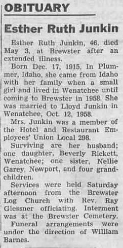
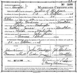
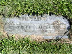
| Description | : | m: Kenneth Leverse Jones (1913-1982) 3 Oct 1933 in Chelan Co, WA m: John Hardman (1908-1990) 24 Oct 1948 in Chelan Co, WA m: Lloyd Junkins 1 Oct 1957 in Chelan Co, WA Esther Ruth Junkin, 46, died May 3, at Brewster after and extended illness. Born Dec. 17, 1915, in Plummer, Idaho, she came from Idaho with her family when a small girl and lived in Wenatchee until coming to Brewster in 1958. She was married to Lloyd Junkin in Wenatchee, Oct. 12, 1958. Mrs. Junkin was member of the Hotel and Restaurant Employees' Union Local 298. Surviving are her husband; one daughter, Beverly Rickett,... Read More |
frequently asked questions (FAQ):
-
Where is Esther Ruth Warner Junkins's memorial?
Esther Ruth Warner Junkins's memorial is located at: Rai Valley Cemetery, Rai Valley, Marlborough District, New Zealand.
-
When did Esther Ruth Warner Junkins death?
Esther Ruth Warner Junkins death on 3 May 1961 in Brewster, Okanogan County, Washington, USA
-
Where are the coordinates of the Esther Ruth Warner Junkins's memorial?
Latitude: -41.2127080
Longitude: 173.5802470
Family Members:
Parent

Spouse

Siblings
Flowers:


Nearby Cemetories:
1. Rai Valley Cemetery
Rai Valley, Marlborough District, New Zealand
Coordinate: -41.2127080, 173.5802470
2. Te Horo Cemetery
Canvastown, Marlborough District, New Zealand
Coordinate: -41.2887942, 173.6652268
3. Ruapeka Cemetery
Canvastown, Marlborough District, New Zealand
Coordinate: -41.2883780, 173.6901440
4. Old Māori Cemetery
Nelson, Nelson City, New Zealand
Coordinate: -41.1610660, 173.4418390
5. Hira Cemetery
Nelson, Nelson City, New Zealand
Coordinate: -41.2104610, 173.3925440
6. Deep Creek Cemetery
Deep Creek, Marlborough District, New Zealand
Coordinate: -41.3556480, 173.6320210
7. Kaiuma Bay Graves
Kaiuma, Marlborough District, New Zealand
Coordinate: -41.2362962, 173.7875701
8. Havelock Cemetery
Havelock, Marlborough District, New Zealand
Coordinate: -41.2826300, 173.7684800
9. Saint Andrew's Cemetery
Nelson, Nelson City, New Zealand
Coordinate: -41.2066910, 173.3599720
10. McLaren's Grave
Nelson City, New Zealand
Coordinate: -41.0722901, 173.6998022
11. Wakapuaka Cemetery
Nelson, Nelson City, New Zealand
Coordinate: -41.2544590, 173.3032500
12. Mahakipawa
Linkwater, Marlborough District, New Zealand
Coordinate: -41.2892290, 173.8474970
13. Nelson Gaol Yard
Nelson, Nelson City, New Zealand
Coordinate: -41.2773540, 173.2857490
14. Hallowell Cemetery
Nelson, Nelson City, New Zealand
Coordinate: -41.2774690, 173.2857200
15. Quaker's Acre
Nelson, Nelson City, New Zealand
Coordinate: -41.2756190, 173.2806640
16. Fairfield Cemetery
Nelson, Nelson City, New Zealand
Coordinate: -41.2827760, 173.2832300
17. Haven Cemetery
Nelson, Nelson City, New Zealand
Coordinate: -41.2732100, 173.2603300
18. Haulashore Island
Nelson, Nelson City, New Zealand
Coordinate: -41.2691290, 173.2589020
19. Marsden Cemetery
Nelson, Nelson City, New Zealand
Coordinate: -41.3178960, 173.2488480
20. St Barnabas Anglican Churchyard
Stoke, Nelson City, New Zealand
Coordinate: -41.3126340, 173.2351600
21. St. Mary's Orphanage Cemetery
Nelson City, New Zealand
Coordinate: -41.3302150, 173.2449810
22. Seaview Cemetery
Nelson, Nelson City, New Zealand
Coordinate: -41.3037350, 173.2262930
23. Cosy Dell Cemetery
Marlborough District, New Zealand
Coordinate: -40.9844062, 173.8306950
24. Bartlett's Creek Cemetery
Onamalutu, Marlborough District, New Zealand
Coordinate: -41.5136730, 173.5891660