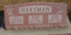
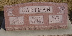
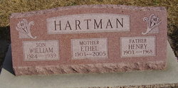
Ethel E. Fisher Hartman
| Birth | : | 11 Dec 1903 Red Cloud, Webster County, Nebraska, USA |
| Death | : | 28 Oct 2005 Hastings, Adams County, Nebraska, USA |
| Burial | : | Pilgrim Home Cemetery, Holland, Ottawa County, USA |
| Coordinate | : | 42.7825012, -86.0894012 |
| Plot | : | SW section Lot 182 |
| Description | : | ETHEL E. HARTMAN Hastings resident Ethel E. (Fisher) Hartman, 101, died Friday; Oct. 28, 200S at Good Samaritan Village Perkins Pavilion. Services are 11 a.m. Monday at St. Paul's Lutheran Church in Blue Hill with the Revs. Annette Minderman and Earl Higgins officiating. Burial will be in Blue Hill Cemetery. Merten-Butler Mortuary of Blue Hill is in charge of the arrangements. Mrs. Hartman was born Dec. 11, 1903, to William H. and Catherine "Katie" (Ailes) Fisher in Red Cloud. On Feb. 4, 1922, she married Henry W. Hartman at Blue Hill. He preceded her in death... Read More |
frequently asked questions (FAQ):
-
Where is Ethel E. Fisher Hartman's memorial?
Ethel E. Fisher Hartman's memorial is located at: Pilgrim Home Cemetery, Holland, Ottawa County, USA.
-
When did Ethel E. Fisher Hartman death?
Ethel E. Fisher Hartman death on 28 Oct 2005 in Hastings, Adams County, Nebraska, USA
-
Where are the coordinates of the Ethel E. Fisher Hartman's memorial?
Latitude: 42.7825012
Longitude: -86.0894012
Family Members:
Parent
Spouse
Siblings
Children
Flowers:
Nearby Cemetories:
1. Pilgrim Home Cemetery
Holland, Ottawa County, USA
Coordinate: 42.7825012, -86.0894012
2. First Presbyterian Church Memorial Gardens
Holland, Ottawa County, USA
Coordinate: 42.7728180, -86.1006290
3. Hope Church Memorial Garden
Holland, Ottawa County, USA
Coordinate: 42.7874985, -86.1088867
4. Grace Episcopal Church Gardens
Holland, Ottawa County, USA
Coordinate: 42.7763770, -86.1111190
5. Zion Lutheran Church Memorial Garden
Holland, Ottawa County, USA
Coordinate: 42.7692980, -86.1116280
6. Restlawn Memorial Gardens
Holland, Ottawa County, USA
Coordinate: 42.7952995, -86.0639038
7. North Holland Cemetery
Holland, Ottawa County, USA
Coordinate: 42.8133011, -86.1022034
8. New Groningen Cemetery
Zeeland, Ottawa County, USA
Coordinate: 42.7991982, -86.0449982
9. Graafschap Cemetery
Holland, Ottawa County, USA
Coordinate: 42.7694016, -86.1369019
10. East Holland Cemetery
Fillmore Township, Allegan County, USA
Coordinate: 42.7661018, -86.0436020
11. Graafschap Christian Reformed Church Cemetery
Graafschap, Allegan County, USA
Coordinate: 42.7524310, -86.1328970
12. Central Park Reformed Church Memorial Gardens
Holland, Ottawa County, USA
Coordinate: 42.7747600, -86.1575220
13. Felch Street Cemetery
Holland Township, Ottawa County, USA
Coordinate: 42.8207090, -86.0326260
14. Noordeloos Cemetery
Holland Township, Ottawa County, USA
Coordinate: 42.8356018, -86.0535965
15. Zeeland Cemetery
Zeeland, Ottawa County, USA
Coordinate: 42.8085310, -86.0140760
16. Old Van Den Bosch Family Farm Cemetery
Zeeland, Ottawa County, USA
Coordinate: 42.8240500, -86.0256100
17. Overisel Settlers Cemetery
Overisel, Allegan County, USA
Coordinate: 42.7287422, -86.0142589
18. Overisel Cemetery
Overisel, Allegan County, USA
Coordinate: 42.7318510, -86.0025290
19. Lakewood Cemetery
Holland, Ottawa County, USA
Coordinate: 42.8050003, -86.1994019
20. West Drenthe Cemetery
Drenthe, Ottawa County, USA
Coordinate: 42.7834960, -85.9749050
21. Lakeshore Cemetery
Holland, Ottawa County, USA
Coordinate: 42.8283005, -86.1968994
22. Van Dam Family Cemetery
Overisel, Allegan County, USA
Coordinate: 42.7605475, -85.9597169
23. Old Vriesland Cemetery
Zeeland, Ottawa County, USA
Coordinate: 42.8050995, -85.9570313
24. VanDam Family Cemetery
Drenthe, Ottawa County, USA
Coordinate: 42.7597430, -85.9566880

