

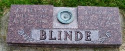
Ethel Frances Marie Hahn Blinde
| Birth | : | 11 Jul 1915 Johnson, Nemaha County, Nebraska, USA |
| Death | : | 15 Aug 1986 Auburn, Nemaha County, Nebraska, USA |
| Burial | : | Mangatainoka Cemetery, Pahiatua, Tararua District, New Zealand |
| Coordinate | : | -40.4250620, 175.8597850 |
| Description | : | Ethel Hahn, daughter of L.W. and Marie hahn born one of 2 children. She was baptized and confirmed at Zion Lutheran Church north of Johnson. She attended school at Graf and went on to graduate from Johnson High School. She married April 28, 1940 to Herman H.O.Blinde at Zion Lutheran Church, Johnson, Ne. Two daughters were born, they were Judy Ann and Sharon Marie. She died at their home and reached the age of 71 years, one month and 4 days. She was preceded in death by her parents and a grandchild. She was survived by husband Herman Blinde,... Read More |
frequently asked questions (FAQ):
-
Where is Ethel Frances Marie Hahn Blinde's memorial?
Ethel Frances Marie Hahn Blinde's memorial is located at: Mangatainoka Cemetery, Pahiatua, Tararua District, New Zealand.
-
When did Ethel Frances Marie Hahn Blinde death?
Ethel Frances Marie Hahn Blinde death on 15 Aug 1986 in Auburn, Nemaha County, Nebraska, USA
-
Where are the coordinates of the Ethel Frances Marie Hahn Blinde's memorial?
Latitude: -40.4250620
Longitude: 175.8597850
Family Members:
Parent
Spouse
Siblings
Children
Flowers:


Nearby Cemetories:
1. Mangatainoka Cemetery
Pahiatua, Tararua District, New Zealand
Coordinate: -40.4250620, 175.8597850
2. Mangahao Cemetery
Ballance, Tararua District, New Zealand
Coordinate: -40.4276820, 175.7890440
3. Kaitawa Cemetery
Kaitawa, Tararua District, New Zealand
Coordinate: -40.4939310, 175.8824710
4. Lawn Woodville Cemetery
Woodville, Tararua District, New Zealand
Coordinate: -40.3390540, 175.8807710
5. RSA Woodville Cemetery
Woodville, Tararua District, New Zealand
Coordinate: -40.3362310, 175.8345210
6. Old Gorge Cemetery
Woodville, Tararua District, New Zealand
Coordinate: -40.3361206, 175.8332520
7. Ashhurst Cemetery
Ashhurst, Palmerston North City, New Zealand
Coordinate: -40.3013600, 175.7576040
8. Kumeroa Cemetery
Kumeroa, Tararua District, New Zealand
Coordinate: -40.3294480, 176.0238960
9. Kelvin Grove Cemetery
Palmerston North, Palmerston North City, New Zealand
Coordinate: -40.3239060, 175.6616870
10. Terrace End Cemetery
Palmerston North, Palmerston North City, New Zealand
Coordinate: -40.3427170, 175.6433160
11. St Peter's Anglican Church
Roslyn, Palmerston North City, New Zealand
Coordinate: -40.3468897, 175.6279770
12. All Saint's Anglican Church
Palmerston North, Palmerston North City, New Zealand
Coordinate: -40.3581590, 175.6107926
13. Newman Cemetery
Eketahuna, Tararua District, New Zealand
Coordinate: -40.6154770, 175.7134490
14. Bunnythorpe Cemetery
Palmerston North, Palmerston North City, New Zealand
Coordinate: -40.2867770, 175.6272590
15. Tahoraiti Urupā
Dannevirke, Tararua District, New Zealand
Coordinate: -40.2428680, 176.0574580
16. First Cemetery of Eketahuna
Eketahuna, Tararua District, New Zealand
Coordinate: -40.6467990, 175.7136840
17. Alfredton Cemetery
Alfredton, Tararua District, New Zealand
Coordinate: -40.6808500, 175.8670160
18. Pohangina Cemetery
Pohangina, Manawatu District, New Zealand
Coordinate: -40.1682490, 175.7946660
19. Eketahuna Lawn Cemetery
Eketahuna, Tararua District, New Zealand
Coordinate: -40.6538700, 175.6883400
20. Calleson Family Cemetery
Palmerston North, Palmerston North City, New Zealand
Coordinate: -40.3814600, 175.5157840
21. Aorangi Urupā
Manawatu District, New Zealand
Coordinate: -40.2443660, 175.5870110
22. Pongaroa cemetery
Pahiatua, Tararua District, New Zealand
Coordinate: -40.5448890, 176.1975300
23. Settlers Cemetery
Dannevirke, Tararua District, New Zealand
Coordinate: -40.2046600, 176.1107900
24. Mangatera Cemetery
Dannevirke, Tararua District, New Zealand
Coordinate: -40.1883520, 176.1180990