
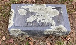

Ethel Gertrude “Gertie” Bonds Holman
| Birth | : | 18 Aug 1889 Oregon County, Missouri, USA |
| Death | : | 23 Apr 1937 Oregon County, Missouri, USA |
| Burial | : | Criglersville Cemetery, Criglersville, Madison County, USA |
| Coordinate | : | 38.4634880, -78.3030120 |
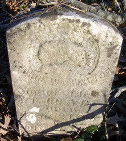
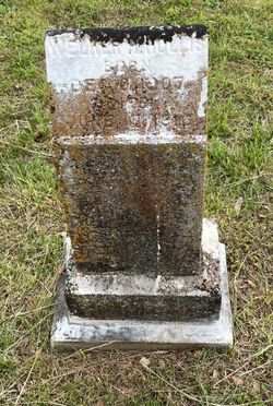
| Description | : | Daughter of Andrew Green Bonds & Essie Viola (Standley) Bonds. Married Revel Lee Hollis about 1907. Mother of Welker Hollis. Married Elbert Lee Grooms after 1911. Mother of Ruby Helen Grooms. Married Elgan Nevels Holman after 1935, divorced. Per MO Death certificate #17138, burial 24/Apr/1937. |
frequently asked questions (FAQ):
-
Where is Ethel Gertrude “Gertie” Bonds Holman's memorial?
Ethel Gertrude “Gertie” Bonds Holman's memorial is located at: Criglersville Cemetery, Criglersville, Madison County, USA.
-
When did Ethel Gertrude “Gertie” Bonds Holman death?
Ethel Gertrude “Gertie” Bonds Holman death on 23 Apr 1937 in Oregon County, Missouri, USA
-
Where are the coordinates of the Ethel Gertrude “Gertie” Bonds Holman's memorial?
Latitude: 38.4634880
Longitude: -78.3030120
Family Members:
Parent

Spouse
Siblings
Children
Flowers:


Nearby Cemetories:
1. Rosser - Hawkins Cemetery
Criglersville, Madison County, USA
Coordinate: 38.4630290, -78.2998180
2. Gallihugh - Berry Cemetery
Ruth, Madison County, USA
Coordinate: 38.4552994, -78.3146973
3. Mount Zion Baptist Church Cemetery
Syria, Madison County, USA
Coordinate: 38.4744850, -78.3118600
4. Weaver Cemetery
Banco, Madison County, USA
Coordinate: 38.4626550, -78.2793930
5. Oak Grove United Methodist Church Cemetery
Aylor, Madison County, USA
Coordinate: 38.4417580, -78.2998840
6. Brown-Murray-Utz-Leathers Cemetery
Syria, Madison County, USA
Coordinate: 38.4897220, -78.3103090
7. Aylor Family Cemetery
Aylor, Madison County, USA
Coordinate: 38.4358880, -78.3050390
8. Lorenz Gaar Family Cemetery
Aylor, Madison County, USA
Coordinate: 38.4339400, -78.2890200
9. Kite Family Cemetery
Syria, Madison County, USA
Coordinate: 38.4918090, -78.3401920
10. Mount Carmel Baptist Church Cemetery
Haywood, Madison County, USA
Coordinate: 38.4548850, -78.2516670
11. Mount Calvary Baptist Church Cemetery
Haywood, Madison County, USA
Coordinate: 38.4560300, -78.2475490
12. Victory Freewill Baptist Church Cemetery
Madison County, USA
Coordinate: 38.4282990, -78.2660980
13. Yowell Family Cemetery
Etlan, Madison County, USA
Coordinate: 38.5071600, -78.2771400
14. Pleasant Grove Cemetery
Etlan, Madison County, USA
Coordinate: 38.5085050, -78.2738890
15. Tanner Cemetery
Haywood, Madison County, USA
Coordinate: 38.4748260, -78.2395990
16. Goodall Farm Cemetery
Graves Mill, Madison County, USA
Coordinate: 38.4389730, -78.3622600
17. Blankenbaker Burial Ground
Madison, Madison County, USA
Coordinate: 38.4383340, -78.2433640
18. Hoffman Family Cemetery
Madison, Madison County, USA
Coordinate: 38.4047360, -78.2892580
19. Lillard Cemetery
Graves Mill, Madison County, USA
Coordinate: 38.4216420, -78.3581110
20. Rosson Cemetery
Haywood, Madison County, USA
Coordinate: 38.4801690, -78.2260630
21. Kite Family Cemetery
Graves Mill, Madison County, USA
Coordinate: 38.4148370, -78.3555420
22. Jenkins Family Cemetery 2
Stanley, Page County, USA
Coordinate: 38.4719726, -78.2213303
23. Jarrell Cemetery
Graves Mill, Madison County, USA
Coordinate: 38.4110380, -78.3513450
24. Graves Chapel Cemetery
Graves Mill, Madison County, USA
Coordinate: 38.4232290, -78.3707610