
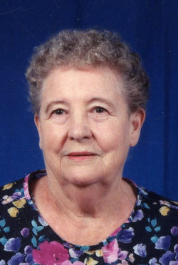
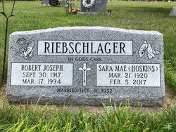
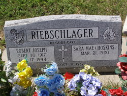
Ethel Mae “Sara” Hoskins Riebschlager
| Birth | : | 21 Mar 1920 Miami, Ottawa County, Oklahoma, USA |
| Death | : | 5 Feb 2017 Lexington, Dawson County, Nebraska, USA |
| Burial | : | Evergreen Cemetery, Lexington, Dawson County, USA |
| Coordinate | : | 40.7639008, -99.6791992 |
| Plot | : | DIV. 6, BLOCK 398, LOT 2, SPACE 2. |
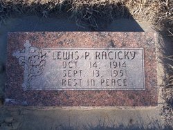
| Description | : | Sara Mae Riebschlager, of Lexington, Nebraska, passed away peacefully in her home surrounded by her children on Sunday, February 5, 2017, at the age of 96 years, 10 months, and 15 days. She was born March 21, 1920, in Miami, Oklahoma to James Henry and Matilda Amelia (Wiegel) Hoskins. The family lived in various places throughout the state. Sara was married to Lewis Racicky on October 24, 1937, in Erickson, Nebraska. To this union four children were born; Loretta Jean, Robert Anthony, Mary Phyllis, and Cathy Kay. Lewis was killed in a farming tractor accident on September 13, 1951. She then... Read More |
frequently asked questions (FAQ):
-
Where is Ethel Mae “Sara” Hoskins Riebschlager's memorial?
Ethel Mae “Sara” Hoskins Riebschlager's memorial is located at: Evergreen Cemetery, Lexington, Dawson County, USA.
-
When did Ethel Mae “Sara” Hoskins Riebschlager death?
Ethel Mae “Sara” Hoskins Riebschlager death on 5 Feb 2017 in Lexington, Dawson County, Nebraska, USA
-
Where are the coordinates of the Ethel Mae “Sara” Hoskins Riebschlager's memorial?
Latitude: 40.7639008
Longitude: -99.6791992
Family Members:
Parent
Spouse
Siblings
Children

Flowers:


Nearby Cemetories:
1. Evergreen Cemetery
Lexington, Dawson County, USA
Coordinate: 40.7639008, -99.6791992
2. Saint Anns Cemetery
Lexington, Dawson County, USA
Coordinate: 40.7789001, -99.7114029
3. First United Methodist Church Columbarium
Lexington, Dawson County, USA
Coordinate: 40.7810000, -99.7397000
4. Greenwood Cemetery
Lexington, Dawson County, USA
Coordinate: 40.7956467, -99.7286682
5. Mount Hope Cemetery
Dawson County, USA
Coordinate: 40.8293991, -99.6733017
6. Robb Cemetery
Smithfield, Gosper County, USA
Coordinate: 40.6710691, -99.6996001
7. Plum Creek Massacre Cemetery
Phelps County, USA
Coordinate: 40.6726840, -99.6058220
8. Hewitt Cemetery
Lexington, Dawson County, USA
Coordinate: 40.8588982, -99.7769012
9. Overton Cemetery
Overton, Dawson County, USA
Coordinate: 40.7317009, -99.5222015
10. Hillside Cemetery
Dawson County, USA
Coordinate: 40.8946991, -99.7869034
11. Adullam Cemetery
Bertrand, Phelps County, USA
Coordinate: 40.6265000, -99.5856000
12. Buffalo Grove Presbyterian Church Cemetery
Buffalo, Dawson County, USA
Coordinate: 40.8721000, -99.8270000
13. Grace Cemetery
Cozad, Dawson County, USA
Coordinate: 40.8602982, -99.8644028
14. Quakerville Cemetery
Gosper County, USA
Coordinate: 40.6189003, -99.8097000
15. Platte Valley Cemetery
Phelps County, USA
Coordinate: 40.6425018, -99.5028000
16. Sandstrom Cemetery
Phelps County, USA
Coordinate: 40.5983009, -99.5661011
17. Saint Johns Lutheran Cemetery
Lexington, Dawson County, USA
Coordinate: 40.9019012, -99.8458023
18. Keely Cemetery
Smithfield, Gosper County, USA
Coordinate: 40.5727500, -99.6563500
19. Hope Lutheran Cemetery
Smithfield, Gosper County, USA
Coordinate: 40.5667500, -99.6800000
20. Immanuel Cemetery
Bertrand, Phelps County, USA
Coordinate: 40.5682983, -99.6283035
21. Elwood Cemetery
Elwood, Gosper County, USA
Coordinate: 40.5999300, -99.8397300
22. Williamsburg Cemetery
Phelps County, USA
Coordinate: 40.6490290, -99.4543150
23. Jewell Cemetery
Sumner, Dawson County, USA
Coordinate: 40.9599991, -99.5646973
24. Saint Patricks Cemetery
Eddyville, Dawson County, USA
Coordinate: 40.9747009, -99.6093979