

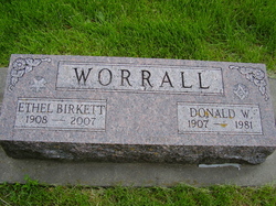
Ethel Marie Birkett Worrall
| Birth | : | 27 Jan 1908 West Liberty, Muscatine County, Iowa, USA |
| Death | : | 5 Oct 2007 West Branch, Cedar County, Iowa, USA |
| Burial | : | Holbrook Cemetery, Holbrook, Greater Hume Shire, Australia |
| Coordinate | : | -35.7124000, 147.3153350 |
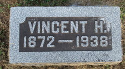
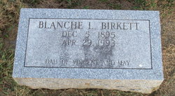
| Description | : | Obituary: West Branch Times, West Branch (Cedar Co.) IA, 10 Oct 2007. "Ethel Marie (Birkett) Worrall, 99, passed away Oct. 5, 2007, at the Crestview Nursing and Rehab Center in West Branch following an extended illness. Memorial services were held 10 a.m. Wednesday, Oct. 10, at the Springdale United Methodist Church with Rev. Ruth Blayer officiating. The Henderson-Barker Funeral Home in West Branch is in charge of arrangements. "Ethel was born Jan. 29, 1908, in West Liberty the daughter of Vincent and May James Birkett. In 1955, she was united in marriage to Donald Worrall whom she met while working... Read More |
frequently asked questions (FAQ):
-
Where is Ethel Marie Birkett Worrall's memorial?
Ethel Marie Birkett Worrall's memorial is located at: Holbrook Cemetery, Holbrook, Greater Hume Shire, Australia.
-
When did Ethel Marie Birkett Worrall death?
Ethel Marie Birkett Worrall death on 5 Oct 2007 in West Branch, Cedar County, Iowa, USA
-
Where are the coordinates of the Ethel Marie Birkett Worrall's memorial?
Latitude: -35.7124000
Longitude: 147.3153350
Family Members:
Parent

Spouse
Siblings

Flowers:


Nearby Cemetories:
1. Holbrook Cemetery
Holbrook, Greater Hume Shire, Australia
Coordinate: -35.7124000, 147.3153350
2. Woomargama Cemetery
Woomargama, Greater Hume Shire, Australia
Coordinate: -35.8308350, 147.2570460
3. Cookardinia Cemetery
Cookardinia, Greater Hume Shire, Australia
Coordinate: -35.5618700, 147.2514700
4. Culcairn General Cemetery
Culcairn, Greater Hume Shire, Australia
Coordinate: -35.6557100, 147.0566550
5. Little Billabong
Little Billabong, Greater Hume Shire, Australia
Coordinate: -35.5485000, 147.5346100
6. Mullengandra Cemetery
Mullengandra, Greater Hume Shire, Australia
Coordinate: -35.9165700, 147.1505200
7. Henty General Cemetery
Henty, Greater Hume Shire, Australia
Coordinate: -35.4974940, 147.0245050
8. Bowna General Cemetery
Table Top, Albury City, Australia
Coordinate: -35.9876250, 147.0899820
9. Gerogery St Peters Lutheran Cemetery
Gerogery, Greater Hume Shire, Australia
Coordinate: -35.8589680, 146.9415790
10. Gerogery West General Cemetery
Gerogery, Greater Hume Shire, Australia
Coordinate: -35.8719800, 146.9485540
11. Walla Walla General Cemetery
Walla-Walla, Greater Hume Shire, Australia
Coordinate: -35.7552040, 146.8988830
12. Edgehill Imanuel Lutheran Cemetery
Ryan, Lockhart Shire, Australia
Coordinate: -35.5250700, 146.9558100
13. Jingellic Cemetery
Jingellic, Greater Hume Shire, Australia
Coordinate: -35.9396780, 147.6563980
14. Granya Cemetery
Granya, Towong Shire, Australia
Coordinate: -36.0959770, 147.3185400
15. Bethel Trinity Lutheran Cemetery
Glenellen, Greater Hume Shire, Australia
Coordinate: -35.8664700, 146.8809340
16. Talgarno Cemetery
Bethanga, Towong Shire, Australia
Coordinate: -36.0737270, 147.1469690
17. Munyabla Cemetery
Munyabla, Lockhart Shire, Australia
Coordinate: -35.4993160, 146.9176250
18. Jindera General Cemetery
Jindera, Greater Hume Shire, Australia
Coordinate: -35.9356290, 146.9096520
19. Walwa Cemetery
Walwa, Towong Shire, Australia
Coordinate: -35.9502930, 147.7150320
20. Yerong Creek Cemetery
Yerong Creek, Lockhart Shire, Australia
Coordinate: -35.3764960, 147.0226730
21. St Mary's Catholic Cemetery
Jindera, Greater Hume Shire, Australia
Coordinate: -35.9635600, 146.8942600
22. Jindera St Johns Lutheran Cemetery
Jindera, Greater Hume Shire, Australia
Coordinate: -35.9539800, 146.8727600
23. Jindera Bethlehem Lutheran Cemetery
Jindera, Greater Hume Shire, Australia
Coordinate: -35.9614300, 146.8770000
24. Burrumbuttock Cemetery
Burrumbuttock, Greater Hume Shire, Australia
Coordinate: -35.8399400, 146.7960100