
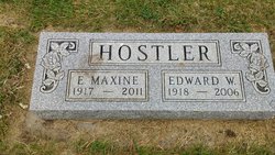
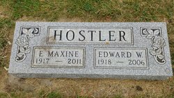
Ethel Maxine Culver Hostler
| Birth | : | 17 Mar 1917 |
| Death | : | 18 Oct 2011 |
| Burial | : | Sacred Heart Cemetery, Carthage, Miner County, USA |
| Coordinate | : | 44.1824989, -97.7089005 |
| Description | : | Ethel Maxine Hostler was born March 17, 1917, rural Cavour, to Lloyd and Hazel (Franzen) Culver. She attended Cavour country school and Cavour High School. She graduated from Huron High School and Huron College. She taught school in Wolsey and the Pine Ridge Indian Reservation. On October 5, 1940, she married Edward Hostler in Chadron, NE. They lived in Batesland, SD, and then moved south of Cavour where she taught in the Richland Country School. In 1947, they moved north of Artesian where they farmed and she also taught at Iroquois, Yale and Carthage. They lived in Custer, Letcher, and... Read More |
frequently asked questions (FAQ):
-
Where is Ethel Maxine Culver Hostler's memorial?
Ethel Maxine Culver Hostler's memorial is located at: Sacred Heart Cemetery, Carthage, Miner County, USA.
-
When did Ethel Maxine Culver Hostler death?
Ethel Maxine Culver Hostler death on 18 Oct 2011 in
-
Where are the coordinates of the Ethel Maxine Culver Hostler's memorial?
Latitude: 44.1824989
Longitude: -97.7089005
Family Members:
Parent

Spouse
Siblings
Children
Flowers:


Nearby Cemetories:
1. Trinity Lutheran Cemetery New
Carthage, Miner County, USA
Coordinate: 44.1812172, -97.7092285
2. Pleasant View Cemetery
Carthage, Miner County, USA
Coordinate: 44.1693993, -97.6983032
3. Trinity Lutheran Cemetery
Carthage, Miner County, USA
Coordinate: 44.1697006, -97.7403030
4. Esmond Cemetery
Esmond, Kingsbury County, USA
Coordinate: 44.2578000, -97.7728000
5. Prairie Flower Cemetery
Fedora, Miner County, USA
Coordinate: 44.0969009, -97.8169022
6. Cloverleaf Colony Cemetery
Howard, Miner County, USA
Coordinate: 44.1858368, -97.5361023
7. Dow Cemetery
Manchester, Kingsbury County, USA
Coordinate: 44.3112200, -97.6930700
8. Morgans Cemetery
Miner County, USA
Coordinate: 44.0602989, -97.7707977
9. Berton Cemetery
Miner County, USA
Coordinate: 44.1542015, -97.4903030
10. Lutheran Cemetery
Artesian, Sanborn County, USA
Coordinate: 44.0967700, -97.9117600
11. Saint Peter Cemetery
De Smet, Kingsbury County, USA
Coordinate: 44.3046000, -97.5313000
12. Saint Anthony's Catholic Cemetery
Sanborn County, USA
Coordinate: 44.1478400, -97.9504400
13. Saint Nicholas Cemetery
Roswell, Miner County, USA
Coordinate: 44.0057793, -97.6929626
14. IOOF Cemetery
Vilas, Miner County, USA
Coordinate: 44.0225067, -97.5940399
15. Norwegian Lutheran Cemetery
Sanborn County, USA
Coordinate: 44.0966988, -97.9332962
16. Immanuel Lutheran Cemetery
Belle Prairie Township, Beadle County, USA
Coordinate: 44.2341003, -97.9559021
17. Belleview Cemetery
Howard, Miner County, USA
Coordinate: 44.1116080, -97.4686910
18. Manchester Cemetery
Manchester, Kingsbury County, USA
Coordinate: 44.3701930, -97.7125530
19. Roswell Cemetery
Roswell, Miner County, USA
Coordinate: 43.9939003, -97.6919022
20. Fedora Cemetery
Fedora, Miner County, USA
Coordinate: 43.9996986, -97.7906036
21. Saint Pauls Catholic Cemetery
Iroquois, Kingsbury County, USA
Coordinate: 44.3679500, -97.8370300
22. Maplewood Cemetery
Iroquois, Kingsbury County, USA
Coordinate: 44.3679000, -97.8385100
23. Pearl Creek Colony Cemetery
Pearl Creek Colony, Beadle County, USA
Coordinate: 44.3289110, -97.9165710
24. De Smet Cemetery
De Smet, Kingsbury County, USA
Coordinate: 44.3683014, -97.5706024