
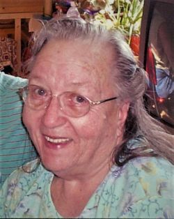
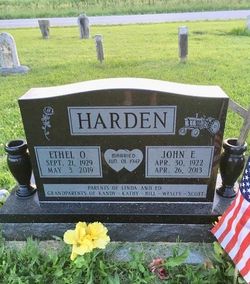
Ethel Orabell Van Velkinburg Harden
| Birth | : | 21 Sep 1929 Cedar Rapids, Linn County, Iowa, USA |
| Death | : | 3 May 2019 Cedar Rapids, Linn County, Iowa, USA |
| Burial | : | Honey Grove Cemetery, Cedar County, USA |
| Coordinate | : | 41.7158012, -91.3266983 |
| Description | : | Ethel O. Harden, 89, of Tipton, passed away Friday, May 3, 2019, at St. Luke’s Hospital in Cedar Rapids. A Gathering of Family and Friends will be 2:00 to 4:00 p.m., Saturday, May 11, at the Tipton VFW in Tipton. Graveside services will be held at Honey Grove Cemetery, rural West Branch, Iowa. Ethel Orabell Van Velkinburg was born September 21, 1929, in Cedar Rapids, the daughter of Edward A. and Ethel (Young) Van Velkinburg. She graduated from Tipton High School, Class of 1947. She married John Edward Harden on June 1, 1947, in A Little Bit... Read More |
frequently asked questions (FAQ):
-
Where is Ethel Orabell Van Velkinburg Harden's memorial?
Ethel Orabell Van Velkinburg Harden's memorial is located at: Honey Grove Cemetery, Cedar County, USA.
-
When did Ethel Orabell Van Velkinburg Harden death?
Ethel Orabell Van Velkinburg Harden death on 3 May 2019 in Cedar Rapids, Linn County, Iowa, USA
-
Where are the coordinates of the Ethel Orabell Van Velkinburg Harden's memorial?
Latitude: 41.7158012
Longitude: -91.3266983
Family Members:
Parent

Spouse
Flowers:


Nearby Cemetories:
1. Honey Grove Cemetery
Cedar County, USA
Coordinate: 41.7158012, -91.3266983
2. United Brethren Cemetery
Cedar County, USA
Coordinate: 41.7445000, -91.3285000
3. Saint Bernadette Catholic Church
West Branch, Cedar County, USA
Coordinate: 41.6755750, -91.3396070
4. Howard Cemetery
Plato, Cedar County, USA
Coordinate: 41.7486303, -91.2918299
5. West Branch Cemetery
West Branch, Cedar County, USA
Coordinate: 41.6765000, -91.3515000
6. Friends Village Cemetery
West Branch, Cedar County, USA
Coordinate: 41.6732000, -91.3470000
7. Oasis Cemetery
Oasis, Johnson County, USA
Coordinate: 41.7005997, -91.3858032
8. Saint Joseph Cemetery
Cedar Valley, Cedar County, USA
Coordinate: 41.7295000, -91.2667000
9. Herbert Hoover National Historic Site
West Branch, Cedar County, USA
Coordinate: 41.6681500, -91.3519900
10. Hickory Grove Cemetery
Cedar County, USA
Coordinate: 41.6637000, -91.3073000
11. Chamness Burial Plot
Springdale, Cedar County, USA
Coordinate: 41.6597351, -91.3182108
12. Springdale Cemetery
Springdale, Cedar County, USA
Coordinate: 41.6786003, -91.2581024
13. Evergreen Hill Cemetery
Cedar Bluff, Cedar County, USA
Coordinate: 41.7867012, -91.3305969
14. Fairview Cemetery
Johnson County, USA
Coordinate: 41.6931000, -91.4171982
15. Saint Bridgets Cemetery
Solon, Johnson County, USA
Coordinate: 41.7779290, -91.3748950
16. Shawver Cemetery
Cedar Bluff, Cedar County, USA
Coordinate: 41.7877998, -91.2874985
17. North Liberty Cemetery
Springdale, Cedar County, USA
Coordinate: 41.6852989, -91.2292023
18. Woodbridge Cemetery
Buchanan, Cedar County, USA
Coordinate: 41.7644005, -91.2294006
19. Morse Cemetery
Morse, Johnson County, USA
Coordinate: 41.7447014, -91.4432983
20. Pee Dee Cemetery
Cedar County, USA
Coordinate: 41.6699982, -91.2142029
21. Downey Cemetery
Downey, Cedar County, USA
Coordinate: 41.6119003, -91.3182983
22. North Scott Cemetery
Johnson County, USA
Coordinate: 41.6634500, -91.4477000
23. Mason-Wallick Cemetery
Cedar Bluff, Cedar County, USA
Coordinate: 41.8199997, -91.3106003
24. Mount Zion Church Cemetery
Cedar County, USA
Coordinate: 41.7343000, -91.1790000