
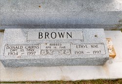
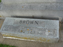
Ethyl Mae Dubbs Brown
| Birth | : | 2 May 1908 Burnt Cabins, Fulton County, Pennsylvania, USA |
| Death | : | 1 Jul 1997 Mercer Island, King County, Washington, USA |
| Burial | : | Riverside Cemetery, Rockford, Floyd County, USA |
| Coordinate | : | 43.0578003, -92.9464035 |
| Plot | : | Section 8 |
| Description | : | Ethyl Dubbs moved with her family as a young child to Crook, Colorado. After graduating from Crook High School, she earned a nursing degree in Greely, Colorado, in 1931. From there, she travelled to Seattle, Washington, where she worked for Swedish Hospital. In 1935 Ethyl went to Honolulu, Hawaii, where she was head nurse in a plantation hospital for six years. On Sept. 22, 1941, she married Ensign Robert Rogers, who was a naval aviator assigned to the cruiser USS Pensacola. The ship left for the Philippines shortly before the Japanese attack on Pearl Harbor, which Ethyl watched from her... Read More |
frequently asked questions (FAQ):
-
Where is Ethyl Mae Dubbs Brown's memorial?
Ethyl Mae Dubbs Brown's memorial is located at: Riverside Cemetery, Rockford, Floyd County, USA.
-
When did Ethyl Mae Dubbs Brown death?
Ethyl Mae Dubbs Brown death on 1 Jul 1997 in Mercer Island, King County, Washington, USA
-
Where are the coordinates of the Ethyl Mae Dubbs Brown's memorial?
Latitude: 43.0578003
Longitude: -92.9464035
Family Members:
Parent
Spouse

Siblings
Flowers:


Nearby Cemetories:
1. Riverside Cemetery
Rockford, Floyd County, USA
Coordinate: 43.0578003, -92.9464035
2. Ulsterville Cemetery
Ulster Township, Floyd County, USA
Coordinate: 43.0936012, -92.8842010
3. Flood Creek Cemetery
Floyd County, USA
Coordinate: 43.0391998, -92.8538971
4. Rock Grove Township Cemetery
Nora Springs, Floyd County, USA
Coordinate: 43.1227989, -92.9880981
5. Rudd Evergreen Cemetery
Rudd, Floyd County, USA
Coordinate: 43.1417007, -92.9214020
6. Park Cemetery
Nora Springs, Floyd County, USA
Coordinate: 43.1444016, -92.9982986
7. Saint Marys Catholic Cemetery
Roseville, Floyd County, USA
Coordinate: 43.0090000, -92.8134000
8. West Saint Charles United Methodist Cemetery
Floyd County, USA
Coordinate: 43.0580597, -92.7897186
9. Westside Cemetery
Marble Rock, Floyd County, USA
Coordinate: 42.9556007, -92.8739014
10. Hillside Cemetery
Marble Rock, Floyd County, USA
Coordinate: 42.9583015, -92.8666992
11. Spring Grove Cemetery
Nora Springs, Floyd County, USA
Coordinate: 43.1631012, -93.0211029
12. Owens Grove Cemetery
Cerro Gordo County, USA
Coordinate: 43.0825005, -93.1144180
13. Saint Patricks Catholic Cemetery
Dougherty, Cerro Gordo County, USA
Coordinate: 42.9227791, -93.0294418
14. Eden Presbyterian Cemetery
Meroa, Mitchell County, USA
Coordinate: 43.2131004, -92.9103012
15. West End Cemetery
Meroa, Mitchell County, USA
Coordinate: 43.2216682, -92.9250031
16. Oakwood Cemetery
Floyd, Floyd County, USA
Coordinate: 43.1178017, -92.7307968
17. Dudley Cemetery
Dudley (historical), Mitchell County, USA
Coordinate: 43.2252998, -92.8743973
18. Rock Creek Cemetery
Meroa, Mitchell County, USA
Coordinate: 43.2352791, -92.9225006
19. Halls Grove Cemetery
Greene, Butler County, USA
Coordinate: 42.8840100, -92.8782300
20. Rock Falls Cemetery
Rock Falls, Cerro Gordo County, USA
Coordinate: 43.2122192, -93.0858307
21. Pleasant Grove Cemetery
Powersville, Floyd County, USA
Coordinate: 42.9441986, -92.7446976
22. Calvary Cemetery
Osage, Mitchell County, USA
Coordinate: 43.2238998, -92.8300018
23. Riverside Cemetery
Charles City, Floyd County, USA
Coordinate: 43.0766983, -92.6881027
24. West Fork Cemetery
Franklin County, USA
Coordinate: 42.8918991, -93.0836029