

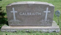
Etta E. Smith Galbraith
| Birth | : | 27 Jul 1874 Canton, Lincoln County, South Dakota, USA |
| Death | : | 31 Dec 1955 Sac City, Sac County, Iowa, USA |
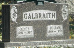
| Burial | : | Newell Cemetery, Newell, Buena Vista County, USA |
| Coordinate | : | 42.6123800, -94.9994800 |
| Description | : | Mary Etta Smith was born the second daughter of Robert H.and Ellen Smith on July 27, 1874 at Canton S. Dak. She passed away at the Loring Hospital the evening of December 31, 1955, at the age of 81 years, 5 months and 4 days. At the age of 3 months she moved with her parents to Montgomery County, Iowa, living there until she was 6 years old when she moved with her parents to a farm just east of Newell. She received her schooling in a country school in Newell township, later she went to Holstein where she finished her high school education. For many years she was a faithful members of the Galbraith Methodist church, later transferring to the Newell... Read More |
frequently asked questions (FAQ):
-
Where is Etta E. Smith Galbraith's memorial?
Etta E. Smith Galbraith's memorial is located at: Newell Cemetery, Newell, Buena Vista County, USA.
-
When did Etta E. Smith Galbraith death?
Etta E. Smith Galbraith death on 31 Dec 1955 in Sac City, Sac County, Iowa, USA
-
Where are the coordinates of the Etta E. Smith Galbraith's memorial?
Latitude: 42.6123800
Longitude: -94.9994800
Family Members:
Parent
Spouse
Siblings
Children

Flowers:


Nearby Cemetories:
1. Newell Cemetery
Newell, Buena Vista County, USA
Coordinate: 42.6123800, -94.9994800
2. Newell Catholic Prairie Cemetery
Newell, Buena Vista County, USA
Coordinate: 42.6144000, -95.0328000
3. Donna Lynn Salis-Christensen Burial Plot
Newell, Buena Vista County, USA
Coordinate: 42.5882134, -95.0544960
4. Varina Cemetery
Newell Township, Buena Vista County, USA
Coordinate: 42.6539993, -94.9339981
5. Saint Johns Church Of Christ Cemetery
Storm Lake, Buena Vista County, USA
Coordinate: 42.7108002, -95.0428009
6. Saint John's Lutheran Cemetery
Albert City, Buena Vista County, USA
Coordinate: 42.7200920, -94.9947630
7. Zion Lutheran Cemetery
Storm Lake, Buena Vista County, USA
Coordinate: 42.7136002, -95.0650024
8. Saint Columbkilles Cemetery
Varina, Pocahontas County, USA
Coordinate: 42.6467018, -94.8443985
9. Nemaha Cemetery
Nemaha, Sac County, USA
Coordinate: 42.5102997, -95.0905991
10. Cedar Township Cemetery
Fonda, Pocahontas County, USA
Coordinate: 42.5810000, -94.8375000
11. Saint Mary's Catholic Cemetery
Storm Lake, Buena Vista County, USA
Coordinate: 42.6470000, -95.1660000
12. Mount Zion Cemetery
Fonda, Pocahontas County, USA
Coordinate: 42.5821991, -94.8300018
13. Storm Lake Cemetery
Storm Lake, Buena Vista County, USA
Coordinate: 42.6352800, -95.1744400
14. Dover Township Cemetery
Varina, Pocahontas County, USA
Coordinate: 42.6896100, -94.8524200
15. Lincoln Township Cemetery
Buena Vista County, USA
Coordinate: 42.7413000, -95.1282000
16. Fairfield Cemetery
Albert City, Buena Vista County, USA
Coordinate: 42.7783012, -94.9692001
17. Saint John Cemetery
Williams Township, Calhoun County, USA
Coordinate: 42.4747009, -94.8672028
18. Marshall Cemetery
Pocahontas County, USA
Coordinate: 42.7633018, -94.8930969
19. Buena Vista Memorial Park Cemetery
Storm Lake, Buena Vista County, USA
Coordinate: 42.6539001, -95.2339020
20. Cedar Cemetery
Sac City, Sac County, USA
Coordinate: 42.4430000, -94.9110000
21. Sacred Heart Cemetery
Early, Sac County, USA
Coordinate: 42.4650002, -95.1446991
22. Immanuel Reformed Cemetery
Schaller, Sac County, USA
Coordinate: 42.5396996, -95.2294006
23. Oakland Cemetery
Sac City, Sac County, USA
Coordinate: 42.4272100, -94.9910760
24. Early Union Cemetery
Early, Sac County, USA
Coordinate: 42.4578018, -95.1425018