
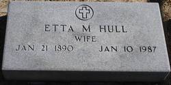
Etta Mae Marsh Hull
| Birth | : | 21 Jan 1890 Nebraska, USA |
| Death | : | 10 Jan 1987 Hastings, Adams County, Nebraska, USA |
| Burial | : | Waldeck Cemetery, Waldeck, Lewis County, USA |
| Coordinate | : | 39.0486860, -80.5095950 |
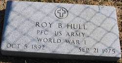
| Description | : | Married to Roy B Hull. |
frequently asked questions (FAQ):
-
Where is Etta Mae Marsh Hull's memorial?
Etta Mae Marsh Hull's memorial is located at: Waldeck Cemetery, Waldeck, Lewis County, USA.
-
When did Etta Mae Marsh Hull death?
Etta Mae Marsh Hull death on 10 Jan 1987 in Hastings, Adams County, Nebraska, USA
-
Where are the coordinates of the Etta Mae Marsh Hull's memorial?
Latitude: 39.0486860
Longitude: -80.5095950
Family Members:
Parent

Spouse
Siblings
Flowers:


Nearby Cemetories:
1. Waldeck Cemetery
Waldeck, Lewis County, USA
Coordinate: 39.0486860, -80.5095950
2. Fisher Cemetery
Weston, Lewis County, USA
Coordinate: 39.0331001, -80.5239029
3. Weston State Hospital Cemetery
Weston, Lewis County, USA
Coordinate: 39.0395050, -80.4727760
4. Dutch Hollow Road Cemetery
Lewis County, USA
Coordinate: 39.0730330, -80.4860520
5. Middle Run Cemetery
Weston, Lewis County, USA
Coordinate: 39.0149994, -80.5081024
6. Old Arnold Cemetery
Weston, Lewis County, USA
Coordinate: 39.0350120, -80.4693550
7. Machpelah Cemetery
Weston, Lewis County, USA
Coordinate: 39.0475400, -80.4640760
8. Gee Lick Cemetery
Weston, Lewis County, USA
Coordinate: 39.0787170, -80.4761610
9. Brownsville Cemetery
Lewis County, USA
Coordinate: 39.0163994, -80.4756012
10. Freemansburg Baptist Cemetery
Freemansburg, Lewis County, USA
Coordinate: 39.0903750, -80.5290080
11. Butcher Cemetery
Turnertown, Lewis County, USA
Coordinate: 39.0727997, -80.4614029
12. Freemansburg United Methodist Church Cemetery
Freemansburg, Lewis County, USA
Coordinate: 39.0913030, -80.5290410
13. Ward Cemetery
Lewis County, USA
Coordinate: 38.9975860, -80.5051990
14. Harrison Grove Cemetery
Lewis County, USA
Coordinate: 39.0107994, -80.5586014
15. Henry Cemetery
Camden, Lewis County, USA
Coordinate: 39.0292350, -80.5751540
16. Jackson Cemetery
Jackson Mill, Lewis County, USA
Coordinate: 39.0974998, -80.4705963
17. Mount Morris Cemetery
Freemansburg, Lewis County, USA
Coordinate: 39.1066510, -80.5128230
18. Beech Grove Cemetery
Weston, Lewis County, USA
Coordinate: 39.1070170, -80.5141540
19. Snyder Cemetery
Churchville, Lewis County, USA
Coordinate: 39.0918312, -80.5624847
20. Forest Lawn Memorial Gardens
Jane Lew, Lewis County, USA
Coordinate: 39.0649986, -80.4328003
21. Smith Family Cemetery
Lewis County, USA
Coordinate: 39.0457993, -80.4297028
22. Rockford-Pletcher Cemetery (Defunct)
Lewis County, USA
Coordinate: 38.9817009, -80.4963989
23. Peterson Cemetery
Weston, Lewis County, USA
Coordinate: 39.0224991, -80.4244003
24. Bailey Cemetery
Westfield, Lewis County, USA
Coordinate: 39.1067470, -80.4560270