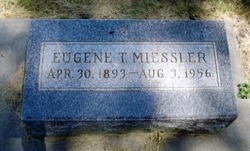
Eugene T. Miessler
| Birth | : | 30 Apr 1893 Columbus, Platte County, Nebraska, USA |
| Death | : | 3 Aug 1956 |
| Burial | : | Bantam Burying Ground, Bantam, Litchfield County, USA |
| Coordinate | : | 41.7250900, -73.2322083 |
| Description | : | Web site @ http://www.usgennet.org/usa/ne/county/platte/whoplabios.html MIESSLER, EUGENE T: Pharmacist; b Columbus, Neb Apr 30, 1893; s of Rev Herman Miessler-Clara Wurmb; ed St Louis Mo HS 1911; St Louis Mo Coll of Pharm, PhG 1915; m Clara Schroeder Aug 23, 1928 Columbus; d Clara Ruth; 1915-18 with Waller T Miessler, St Louis Mo; 1918-19 with H J Horstman Co; 1919-26 owner of Purity Drug; 1921- owner of Miessler Drug Store, Columbus; Loup River Pub Power Dist, dir; Rotary; C of C; Luth Ch; Rep; off 2509 13th; res 1570 33rd Ave, Columbus. |
frequently asked questions (FAQ):
-
Where is Eugene T. Miessler's memorial?
Eugene T. Miessler's memorial is located at: Bantam Burying Ground, Bantam, Litchfield County, USA.
-
When did Eugene T. Miessler death?
Eugene T. Miessler death on 3 Aug 1956 in
-
Where are the coordinates of the Eugene T. Miessler's memorial?
Latitude: 41.7250900
Longitude: -73.2322083
Family Members:
Parent
Spouse
Siblings
Children
Flowers:
Nearby Cemetories:
1. Bantam Burying Ground
Bantam, Litchfield County, USA
Coordinate: 41.7250900, -73.2322083
2. Our Lady of Grace Cemetery
Bantam, Litchfield County, USA
Coordinate: 41.7242250, -73.2325500
3. Saint Anthony Cemetery
Litchfield, Litchfield County, USA
Coordinate: 41.7380409, -73.1982956
4. West Cemetery
Litchfield, Litchfield County, USA
Coordinate: 41.7383003, -73.1980972
5. Headquarters Cemetery
Litchfield, Litchfield County, USA
Coordinate: 41.7517014, -73.2643967
6. Saint Michaels Parish Memorial Garden
Litchfield, Litchfield County, USA
Coordinate: 41.7460500, -73.1887600
7. First Congregational Church Memorial Garden
Litchfield, Litchfield County, USA
Coordinate: 41.7479470, -73.1880910
8. Footville Burying Ground
Morris, Litchfield County, USA
Coordinate: 41.6820602, -73.2374191
9. East Cemetery
Litchfield, Litchfield County, USA
Coordinate: 41.7482070, -73.1813800
10. Morris Burying Ground
Morris, Litchfield County, USA
Coordinate: 41.6883300, -73.1865400
11. Farband Cemetery
Morris, Litchfield County, USA
Coordinate: 41.6890182, -73.1839447
12. Milton Cemetery
Litchfield, Litchfield County, USA
Coordinate: 41.7691994, -73.2782974
13. Davies Hollow Burying Ground
Washington, Litchfield County, USA
Coordinate: 41.6734238, -73.2905426
14. Old Bethlehem Cemetery
Bethlehem, Litchfield County, USA
Coordinate: 41.6486015, -73.2089005
15. New Warren Cemetery
Warren, Litchfield County, USA
Coordinate: 41.7439480, -73.3438790
16. Carmel Hill Cemetery
Bethlehem, Litchfield County, USA
Coordinate: 41.6385994, -73.2481003
17. Warren Center Cemetery Old
Warren, Litchfield County, USA
Coordinate: 41.7467117, -73.3492203
18. Southeast Cemetery
Cornwall, Litchfield County, USA
Coordinate: 41.7877998, -73.3197021
19. West Goshen Cemetery
West Goshen, Litchfield County, USA
Coordinate: 41.8133011, -73.2636032
20. Old Middle Street Cemetery
Goshen, Litchfield County, USA
Coordinate: 41.8181000, -73.2205963
21. Evergreen Cemetery
Bethlehem, Litchfield County, USA
Coordinate: 41.6306000, -73.2099991
22. Bentley Cemetery
Goshen, Litchfield County, USA
Coordinate: 41.8210869, -73.2316971
23. Hillside Cemetery
Torrington, Litchfield County, USA
Coordinate: 41.7871819, -73.1269608
24. Northfield Cemetery
Northfield, Litchfield County, USA
Coordinate: 41.6972008, -73.1031036

