


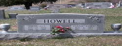
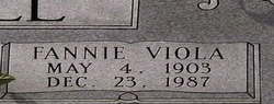
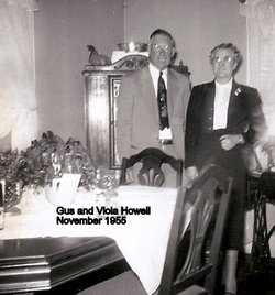
Fannie Viola Sparks Howell
| Birth | : | 4 May 1903 |
| Death | : | 23 Dec 1987 |
| Burial | : | Rebels Creek Cemetery, Boonford, Mitchell County, USA |
| Coordinate | : | 35.9514008, -82.1697006 |
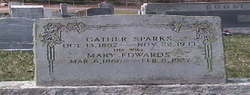
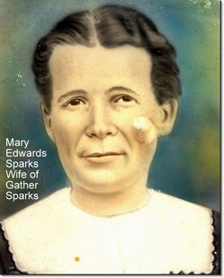
| Description | : | Viola S. Howell, 84, of Route 3, the Rebels Creek community, died Wednesday in a Spruce Pine hospital. She was a native of Mitchell County and her parents were the late Gaither and Mary Edwards Sparks. Surviving are her husband, Gus Howell; a sister, Lela Boone of Bakersville; and a brother, Cecil Sparks of Marion. Services will be at 2 p.m. Saturday in Rebels Creek Baptist Church, of which she was a member. The Revs. Burl Grindstaff, Gerald Grindstaff and Vernon Buchanan will of- ficiate. Burial will be in the church cemetery. The family will receive friends from i? to... Read More |
frequently asked questions (FAQ):
-
Where is Fannie Viola Sparks Howell's memorial?
Fannie Viola Sparks Howell's memorial is located at: Rebels Creek Cemetery, Boonford, Mitchell County, USA.
-
When did Fannie Viola Sparks Howell death?
Fannie Viola Sparks Howell death on 23 Dec 1987 in
-
Where are the coordinates of the Fannie Viola Sparks Howell's memorial?
Latitude: 35.9514008
Longitude: -82.1697006
Family Members:
Parent
Spouse
Siblings
Children

Flowers:


Nearby Cemetories:
1. Rebels Creek Cemetery
Boonford, Mitchell County, USA
Coordinate: 35.9514008, -82.1697006
2. Kona Baptist Church Cemetery
Kona, Mitchell County, USA
Coordinate: 35.9513790, -82.1838930
3. Silver Cemetery
Mitchell County, USA
Coordinate: 35.9514008, -82.1841965
4. Gouge Cemetery
Bandana, Mitchell County, USA
Coordinate: 35.9692001, -82.1722031
5. Silver Chapel Church Cemetery
Bakersville, Mitchell County, USA
Coordinate: 35.9729170, -82.1773460
6. Double Island Baptist Church Cemetery
Double Island, Yancey County, USA
Coordinate: 35.9572570, -82.2023160
7. Snow Hill Cemetery
Bakersville, Mitchell County, USA
Coordinate: 35.9679600, -82.1402400
8. Edd Young Cemetery
Yancey County, USA
Coordinate: 35.9198600, -82.1834000
9. Big Crabtree Cemetery
Estatoe, Mitchell County, USA
Coordinate: 35.9202285, -82.1490755
10. Hall Cemetery
Double Island, Yancey County, USA
Coordinate: 35.9639300, -82.2120800
11. Fred Young Cemetery
Green Mountain, Yancey County, USA
Coordinate: 35.9396500, -82.2138200
12. Thomas Family Cemetery
Burnsville, Yancey County, USA
Coordinate: 35.9767980, -82.2052420
13. Faith Fellowship Church Cemetery
Yancey County, USA
Coordinate: 35.9169300, -82.1913300
14. Wilson-Rector Hill Cemetery
Double Island, Yancey County, USA
Coordinate: 35.9230000, -82.2092300
15. Hughes Cemetery
Double Island, Yancey County, USA
Coordinate: 35.9286003, -82.2164001
16. Conley Cemetery
Mitchell County, USA
Coordinate: 35.9397011, -82.1168976
17. Thomas Cemetery
Double Island, Yancey County, USA
Coordinate: 35.9900017, -82.1980972
18. Woody Cemetery
Double Island, Yancey County, USA
Coordinate: 35.9807200, -82.2119980
19. Pleasant Grove Cemetery
Burnsville, Yancey County, USA
Coordinate: 35.9836920, -82.2108660
20. Wilson Memorial Cemetery
Bakersville, Mitchell County, USA
Coordinate: 35.9938200, -82.1416200
21. Mine Creek Baptist Church Cemetery
Bakersville, Mitchell County, USA
Coordinate: 35.9995600, -82.1676200
22. Johnson Woody Cemetery
Burnsville, Yancey County, USA
Coordinate: 35.9772100, -82.2204800
23. Ledger Baptist Church Cemetery
Ledger, Mitchell County, USA
Coordinate: 35.9675700, -82.1122500
24. Hughes Jones Cemetery
Green Mountain, Yancey County, USA
Coordinate: 35.9531400, -82.2305800