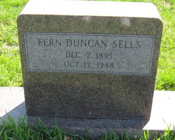
Fern Duncan Sells
| Birth | : | 7 Dec 1896 Maryville, Nodaway County, Missouri, USA |
| Death | : | 13 Oct 1948 Maryville, Nodaway County, Missouri, USA |
| Burial | : | Zion Cemetery, Sherrodsville, Carroll County, USA |
| Coordinate | : | 40.5208015, -81.2518997 |
| Plot | : | Central B (5), Row 16 |
| Description | : | Father: Allen Duncan, b: Nodaway County, Missouri Mother: Lottie Shallers, Nodaway County, Missouri Missouri D/C #33631 |
frequently asked questions (FAQ):
-
Where is Fern Duncan Sells's memorial?
Fern Duncan Sells's memorial is located at: Zion Cemetery, Sherrodsville, Carroll County, USA.
-
When did Fern Duncan Sells death?
Fern Duncan Sells death on 13 Oct 1948 in Maryville, Nodaway County, Missouri, USA
-
Where are the coordinates of the Fern Duncan Sells's memorial?
Latitude: 40.5208015
Longitude: -81.2518997
Family Members:
Parent
Spouse
Siblings
Children
Flowers:
Nearby Cemetories:
1. Zion Cemetery
Sherrodsville, Carroll County, USA
Coordinate: 40.5208015, -81.2518997
2. Roby Cemetery
Sherrodsville, Carroll County, USA
Coordinate: 40.5028000, -81.2382965
3. Saint Francis Catholic Cemetery
Sherrodsville, Carroll County, USA
Coordinate: 40.4951920, -81.2349170
4. Big Spring Cemetery
Carroll County, USA
Coordinate: 40.5576880, -81.2549260
5. Sherrodsville Cemetery
Sherrodsville, Carroll County, USA
Coordinate: 40.4836006, -81.2544022
6. Sherrodsville Memorial Gardens Cemetery
Sherrodsville, Carroll County, USA
Coordinate: 40.4852982, -81.2675018
7. Leavittsville Cemetery
Leavittsville, Carroll County, USA
Coordinate: 40.5133018, -81.1967010
8. New Cumberland Cemetery
New Cumberland, Tuscarawas County, USA
Coordinate: 40.5427777, -81.3016660
9. Price-Rollins Cemetery
Carroll County, USA
Coordinate: 40.5088997, -81.1956024
10. Veteran's Grave
Orange Township, Carroll County, USA
Coordinate: 40.4931470, -81.2003677
11. Davy Cemetery
Warren Township, Tuscarawas County, USA
Coordinate: 40.5576670, -81.3019180
12. Saint Luke Cemetery
Carroll County, USA
Coordinate: 40.5303001, -81.1810989
13. Union Valley Cemetery
Carroll County, USA
Coordinate: 40.5758018, -81.2332993
14. Bethel Cemetery
Leavittsville, Carroll County, USA
Coordinate: 40.4921989, -81.1841965
15. Tressel Cemetery
Mineral City, Tuscarawas County, USA
Coordinate: 40.5635660, -81.3099260
16. Roxford Church Cemetery
Tuscarawas County, USA
Coordinate: 40.4703400, -81.3087200
17. Holmes Methodist Episcopal Cemetery
Goshen, Tuscarawas County, USA
Coordinate: 40.5056200, -81.3392800
18. Congleton Cemetery
Somerdale, Tuscarawas County, USA
Coordinate: 40.5597800, -81.3295200
19. Leesville Cemetery
Leesville, Carroll County, USA
Coordinate: 40.4550018, -81.2114029
20. Hites Cemetery
Carroll County, USA
Coordinate: 40.5942001, -81.2450027
21. Farnsworth Cemetery
Carroll County, USA
Coordinate: 40.5385017, -81.1567001
22. Scotts Cemetery
Carroll County, USA
Coordinate: 40.5386009, -81.1556015
23. Waltz Family Cemetery
Fairfield Township, Tuscarawas County, USA
Coordinate: 40.5437760, -81.3489150
24. McGuire Cemetery
Tabor, Carroll County, USA
Coordinate: 40.5518990, -81.1564026

