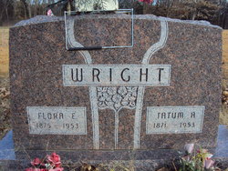
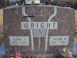
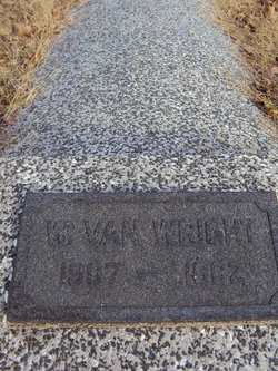
Flora Etta Rippetoe Wright
| Birth | : | 18 Sep 1876 St. Clair County, Missouri, USA |
| Death | : | 31 Aug 1953 Clinton, Henry County, Missouri, USA |
| Burial | : | West Cemetery, Litchfield, Litchfield County, USA |
| Coordinate | : | 41.7383003, -73.1980972 |
| Description | : | The year of birth has a slight confusion : Death Certificate states : 18 Sept 1876 The headstone states : 1875 Without a family member to be found this will remain a mystery. Further more it states the Frank Rippetoe was her father, but Lucinda California Johnson married a James Franklin Rippetoe ( Someone used his middle name on the Death Certificate ) For more information please see Missouri Death Certificate #28413. NOTE: This memorial was transferred to another person who placed the above information on this memorial. For some reason Find A Grave transferred it back to me, along with several other Wright's... Read More |
frequently asked questions (FAQ):
-
Where is Flora Etta Rippetoe Wright's memorial?
Flora Etta Rippetoe Wright's memorial is located at: West Cemetery, Litchfield, Litchfield County, USA.
-
When did Flora Etta Rippetoe Wright death?
Flora Etta Rippetoe Wright death on 31 Aug 1953 in Clinton, Henry County, Missouri, USA
-
Where are the coordinates of the Flora Etta Rippetoe Wright's memorial?
Latitude: 41.7383003
Longitude: -73.1980972
Family Members:
Parent
Spouse
Siblings
Children
Flowers:
Nearby Cemetories:
1. West Cemetery
Litchfield, Litchfield County, USA
Coordinate: 41.7383003, -73.1980972
2. Saint Anthony Cemetery
Litchfield, Litchfield County, USA
Coordinate: 41.7380409, -73.1982956
3. Saint Michaels Parish Memorial Garden
Litchfield, Litchfield County, USA
Coordinate: 41.7460500, -73.1887600
4. First Congregational Church Memorial Garden
Litchfield, Litchfield County, USA
Coordinate: 41.7479470, -73.1880910
5. East Cemetery
Litchfield, Litchfield County, USA
Coordinate: 41.7482070, -73.1813800
6. Bantam Burying Ground
Bantam, Litchfield County, USA
Coordinate: 41.7250900, -73.2322083
7. Our Lady of Grace Cemetery
Bantam, Litchfield County, USA
Coordinate: 41.7242250, -73.2325500
8. Farband Cemetery
Morris, Litchfield County, USA
Coordinate: 41.6890182, -73.1839447
9. Morris Burying Ground
Morris, Litchfield County, USA
Coordinate: 41.6883300, -73.1865400
10. Headquarters Cemetery
Litchfield, Litchfield County, USA
Coordinate: 41.7517014, -73.2643967
11. Footville Burying Ground
Morris, Litchfield County, USA
Coordinate: 41.6820602, -73.2374191
12. Milton Cemetery
Litchfield, Litchfield County, USA
Coordinate: 41.7691994, -73.2782974
13. Hillside Cemetery
Torrington, Litchfield County, USA
Coordinate: 41.7871819, -73.1269608
14. Saint Francis Cemetery
Torrington, Litchfield County, USA
Coordinate: 41.7839012, -73.1149979
15. Scoville Cemetery
Harwinton, Litchfield County, USA
Coordinate: 41.7557983, -73.0942001
16. Old Middle Street Cemetery
Goshen, Litchfield County, USA
Coordinate: 41.8181000, -73.2205963
17. Northfield Cemetery
Northfield, Litchfield County, USA
Coordinate: 41.6972008, -73.1031036
18. Trinity Episcopal Church Memorial Garden
Torrington, Litchfield County, USA
Coordinate: 41.8017470, -73.1225010
19. Collins Cemetery
Goshen, Litchfield County, USA
Coordinate: 41.8238983, -73.1928024
20. Bentley Cemetery
Goshen, Litchfield County, USA
Coordinate: 41.8210869, -73.2316971
21. Center Cemetery
Torrington, Litchfield County, USA
Coordinate: 41.8041992, -73.1196976
22. Old Saint Francis Cemetery
Torrington, Litchfield County, USA
Coordinate: 41.8017349, -73.1154404
23. West Torrington Cemetery
Torrington, Litchfield County, USA
Coordinate: 41.8241997, -73.1669006
24. West Goshen Cemetery
West Goshen, Litchfield County, USA
Coordinate: 41.8133011, -73.2636032

