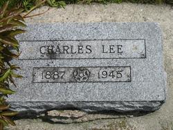
Flora Wray Lee Sturgill
| Birth | : | 24 Nov 1857 Mount Pleasant, Henry County, Iowa, USA |
| Death | : | 20 Sep 1946 Pickering, Nodaway County, Missouri, USA |
| Burial | : | Big Isaac Cemetery, Doddridge County, USA |
| Coordinate | : | 39.2022018, -80.5468979 |
| Plot | : | Row - N to S |
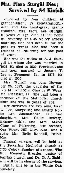
| Description | : | MRS. FLORA STURGILL DIES; SURVIVED BY 84 KINFOLK Survived by four children, 41 grandchildren, 37 great-grandchildren and two great-great grandchildren. Mrs. Flora Lee Sturgill, 88 years of age, died at her home in Pickering at 4:45 o'clock Friday morning. She had been ill for the past six weeks. She had been a resident of Pickering for the past 46 years. She was the widow of A. J. Sturgill to whom she was married in 1923. He died in 1929. Previously she had been married to Jerome T. Lee at Freemont, Ia., in 1875. He died in... Read More |
frequently asked questions (FAQ):
-
Where is Flora Wray Lee Sturgill's memorial?
Flora Wray Lee Sturgill's memorial is located at: Big Isaac Cemetery, Doddridge County, USA.
-
When did Flora Wray Lee Sturgill death?
Flora Wray Lee Sturgill death on 20 Sep 1946 in Pickering, Nodaway County, Missouri, USA
-
Where are the coordinates of the Flora Wray Lee Sturgill's memorial?
Latitude: 39.2022018
Longitude: -80.5468979
Family Members:
Parent
Spouse
Siblings
Children
Flowers:
Nearby Cemetories:
1. Big Isaac Cemetery
Doddridge County, USA
Coordinate: 39.2022018, -80.5468979
2. Day Cemetery
Harrison County, USA
Coordinate: 39.2172012, -80.5325012
3. Mount Lebanon Cemetery
Harrison County, USA
Coordinate: 39.1721992, -80.5603027
4. Morris Cemetery
Benson, Harrison County, USA
Coordinate: 39.1669006, -80.5547028
5. Eddy Cemetery
Miletus, Doddridge County, USA
Coordinate: 39.2321820, -80.5882890
6. Mount Carmel Cemetery
Kincheloe, Harrison County, USA
Coordinate: 39.1693993, -80.5056000
7. Mount Olive Cemetery
Doddridge County, USA
Coordinate: 39.2467003, -80.5721970
8. Green Hill Cemetery
Harrison County, USA
Coordinate: 39.1610080, -80.5112400
9. Greenbrier Seventh Day Baptist Cemetery
Doddridge County, USA
Coordinate: 39.2472000, -80.5830994
10. Jarvisville Baptist Church Cemetery
Jarvisville, Harrison County, USA
Coordinate: 39.2342090, -80.4902440
11. Pleasant Hill Cemetery
Doddridge County, USA
Coordinate: 39.2125015, -80.6185989
12. Snider Cemetery
Doddridge County, USA
Coordinate: 39.1913986, -80.6260986
13. Law Chapel Cemetery
Lewis County, USA
Coordinate: 39.1374670, -80.5739770
14. Pleasant Hill United Methodist Church Cemetery
Harrison County, USA
Coordinate: 39.1469990, -80.4944340
15. Upper Little Indian Fork Cemetery
Coldwater, Doddridge County, USA
Coordinate: 39.1632996, -80.6296997
16. Indian Fork Cemetery
Doddridge County, USA
Coordinate: 39.1739006, -80.6380997
17. Coplin Church Cemetery
Salem, Harrison County, USA
Coordinate: 39.2636420, -80.4861850
18. Smith Chapel Cemetery
Doddridge County, USA
Coordinate: 39.2606010, -80.6175003
19. Seventh-Day Baptist Church Cemetery
Salem, Harrison County, USA
Coordinate: 39.2828510, -80.5550730
20. Mount Zion Baptist Church Cemetery
Weston, Lewis County, USA
Coordinate: 39.1182850, -80.5699220
21. Odd Fellows Cemetery
Salem, Harrison County, USA
Coordinate: 39.2887000, -80.5560000
22. Good Hope Masonic Cemetery
Goodhope, Harrison County, USA
Coordinate: 39.1772300, -80.4393600
23. New Bethel Cemetery
Harrison County, USA
Coordinate: 39.1772003, -80.4392014
24. Post Cemetery
Harrison County, USA
Coordinate: 39.1631012, -80.4413986

