
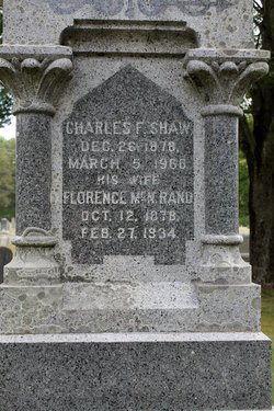
Florence MacNear Rand Shaw
| Birth | : | 12 Oct 1878 |
| Death | : | 27 Feb 1934 |
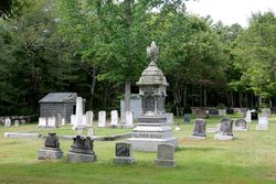
| Burial | : | Mayville Cemetery, Mayville, Traill County, USA |
| Coordinate | : | 47.4927635, -97.3195114 |
| Plot | : | Lot 36 Section C |
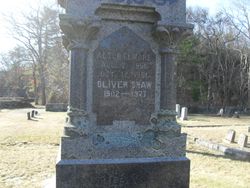
| Description | : | Shaw, Florence McN, Raad ??? Florence MacNear RAND Birth: 12 OCT 1878 in Brookline, Norfolk County, Massachusetts Death: 27 FEB 1934 in Burial: 1934 Union Cemetery, Lot 36, Section C, 33 South Main Street, South Carver, Plymouth County, Massachusett Father: William D. Rand Mother: Emily McNear (?) or MacNear Married: Charles Fletcher Shaw b: 26 DEC 1878 in Watertown, Middlesex County, Massachusetts Married: 14 JUN 1901 in Watertown, Middlesex County, Massachusetts Children Oliver Shaw b: 7 JUN 1902 in Watertown, Middlesex County, Massachusetts |
frequently asked questions (FAQ):
-
Where is Florence MacNear Rand Shaw's memorial?
Florence MacNear Rand Shaw's memorial is located at: Mayville Cemetery, Mayville, Traill County, USA.
-
When did Florence MacNear Rand Shaw death?
Florence MacNear Rand Shaw death on 27 Feb 1934 in
-
Where are the coordinates of the Florence MacNear Rand Shaw's memorial?
Latitude: 47.4927635
Longitude: -97.3195114
Family Members:
Spouse

Children
Flowers:


Nearby Cemetories:
1. Mayville Cemetery
Mayville, Traill County, USA
Coordinate: 47.4927635, -97.3195114
2. Bruflat Cemetery
Viking Township, Traill County, USA
Coordinate: 47.4991989, -97.3827972
3. Aurdal Cemetery
Viking Township, Traill County, USA
Coordinate: 47.5088997, -97.3846970
4. Trinity Lutheran Church Cemetery
Portland, Traill County, USA
Coordinate: 47.4423828, -97.3894196
5. Gran Cemetery
Mayville, Traill County, USA
Coordinate: 47.4693985, -97.2186584
6. Aal Cemetery
Norway Township, Traill County, USA
Coordinate: 47.4405120, -97.1762180
7. Morgan Cemetery
Buxton, Traill County, USA
Coordinate: 47.6002998, -97.2833023
8. North Prairie Cemetery
Wold Township, Traill County, USA
Coordinate: 47.5558014, -97.1781006
9. Carlson Cemetery
Wold Township, Traill County, USA
Coordinate: 47.4986000, -97.1446991
10. Norway Lutheran Cemetery
Mayville, Traill County, USA
Coordinate: 47.4765511, -97.1352310
11. Liening Cemetery
Buxton, Traill County, USA
Coordinate: 47.6208611, -97.2618179
12. Bethany Cemetery
Morgan Township, Traill County, USA
Coordinate: 47.6281013, -97.3171997
13. Little Forks Lutheran Cemetery
Steele County, USA
Coordinate: 47.5559700, -97.5042200
14. Clifford Cemetery
Clifford, Traill County, USA
Coordinate: 47.3605995, -97.3893967
15. Perry Lutheran Cemetery
Sherbrooke, Steele County, USA
Coordinate: 47.4332237, -97.5161057
16. Arnegard Cemetery
Bloomfield Township, Traill County, USA
Coordinate: 47.4071999, -97.1350021
17. Soderberg Cemetery
Buxton, Traill County, USA
Coordinate: 47.5844002, -97.1275024
18. Severson Cemetery
Steele County, USA
Coordinate: 47.5205994, -97.5580978
19. Stavens Memorial Cemetery
Steele County, USA
Coordinate: 47.5905991, -97.5158005
20. Immanuel Lutheran Cemetery West
Buxton, Traill County, USA
Coordinate: 47.5992012, -97.1250000
21. Cummings Cemetery
Ervin Township, Traill County, USA
Coordinate: 47.5088997, -97.0686035
22. Zoar Lutheran Cemetery
Steele County, USA
Coordinate: 47.6289700, -97.4744700
23. Little Forks Church Cemetery
Hatton, Traill County, USA
Coordinate: 47.6390269, -97.4530563
24. Immanuel Lutheran Cemetery North
Buxton, Traill County, USA
Coordinate: 47.6144450, -97.1342790