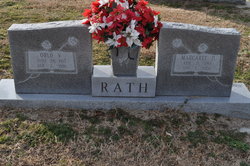
| Birth | : | 21 Jan 1888 Indiana, USA |
| Death | : | 29 Jul 1962 Plymouth, Washington County, North Carolina, USA |
| Burial | : | Mount Hope Cemetery, Litchfield, Hillsdale County, USA |
| Coordinate | : | 42.0332985, -84.7332993 |
| Description | : | Dau. of Benjamin & Destie Skinner Hurst. |
frequently asked questions (FAQ):
-
Where is Flossie L. Hurst Rath's memorial?
Flossie L. Hurst Rath's memorial is located at: Mount Hope Cemetery, Litchfield, Hillsdale County, USA.
-
When did Flossie L. Hurst Rath death?
Flossie L. Hurst Rath death on 29 Jul 1962 in Plymouth, Washington County, North Carolina, USA
-
Where are the coordinates of the Flossie L. Hurst Rath's memorial?
Latitude: 42.0332985
Longitude: -84.7332993
Family Members:
Spouse
Children
Flowers:
Nearby Cemetories:
1. Mount Hope Cemetery
Litchfield, Hillsdale County, USA
Coordinate: 42.0332985, -84.7332993
2. Old Litchfield Cemetery
Litchfield, Hillsdale County, USA
Coordinate: 42.0433330, -84.7533330
3. Sand Creek Cemetery
Litchfield, Hillsdale County, USA
Coordinate: 41.9998950, -84.7568390
4. Case Cemetery
Hillsdale County, USA
Coordinate: 42.0435982, -84.6813965
5. Hiram King Cemetery
Pulaski, Jackson County, USA
Coordinate: 42.0706370, -84.7087120
6. Saratoga Cemetery
Litchfield, Hillsdale County, USA
Coordinate: 42.0585500, -84.7930280
7. Todd Town Cemetery
Litchfield, Hillsdale County, USA
Coordinate: 41.9989430, -84.8036280
8. Johnson Cemetery
Scipio Township, Hillsdale County, USA
Coordinate: 42.0180560, -84.6505560
9. Mosherville Cemetery
Mosherville, Hillsdale County, USA
Coordinate: 42.0597220, -84.6555560
10. First Presbyterian Church Memorial Garden
Jonesville, Hillsdale County, USA
Coordinate: 41.9836930, -84.6611390
11. Sunset View Cemetery
Jonesville, Hillsdale County, USA
Coordinate: 41.9869003, -84.6524963
12. Buck Cemetery
Pulaski, Jackson County, USA
Coordinate: 42.0839539, -84.6563568
13. Allen Cemetery
Allen, Hillsdale County, USA
Coordinate: 41.9561110, -84.7600000
14. Fisher Cemetery
Homer, Calhoun County, USA
Coordinate: 42.1147220, -84.7202770
15. Homer Amish Cemetery
Homer, Calhoun County, USA
Coordinate: 42.1165600, -84.7512800
16. Granger-Pope Cemetery
Mosherville, Hillsdale County, USA
Coordinate: 42.0333330, -84.6125000
17. Allen Township Cemetery
Allen, Hillsdale County, USA
Coordinate: 41.9417100, -84.7096800
18. Whig Center Cemetery
Butler, Branch County, USA
Coordinate: 42.0433330, -84.8611110
19. White Cemetery
Butler, Branch County, USA
Coordinate: 42.0339940, -84.8638920
20. Shooks Prairie Cemetery
Butler, Branch County, USA
Coordinate: 42.0003014, -84.8561020
21. Saint Joseph Cemetery
Clarendon Township, Calhoun County, USA
Coordinate: 42.0727780, -84.8575000
22. Layton Graves
Allen, Hillsdale County, USA
Coordinate: 41.9460869, -84.8142776
23. Pulaski Cemetery
Pulaski, Jackson County, USA
Coordinate: 42.1212410, -84.6422550
24. McNair Cemetery
Pulaski, Jackson County, USA
Coordinate: 42.1008339, -84.6127777


