
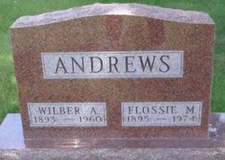
Flossie Mae Surber Andrews
| Birth | : | 19 Oct 1895 Minburn, Dallas County, Iowa, USA |
| Death | : | 15 Dec 1974 |
| Burial | : | Bloomfield Lutheran Cemetery, Upham, McHenry County, USA |
| Coordinate | : | 48.5896988, -100.7249985 |
| Description | : | Flossie Mae Andrews was born on October 19, 1895, at rural Minburn, Iowa, the daughter of Ella and John Arlington Surber. She died on December 15, 1974 at Adel, Iowa, at the aged of 79 years, 1 month, 26 days. She was married to Wilber Andrews on July 30, 1915. Flossie was preceded in death by her husband, Wilber, on December 1, 1960. In addition to her eight children, she is survived by two sisters, Mayme Garwick and Pearl Noland, both of Adel, and 29 granchildren and 13 great grandchildren. |
frequently asked questions (FAQ):
-
Where is Flossie Mae Surber Andrews's memorial?
Flossie Mae Surber Andrews's memorial is located at: Bloomfield Lutheran Cemetery, Upham, McHenry County, USA.
-
When did Flossie Mae Surber Andrews death?
Flossie Mae Surber Andrews death on 15 Dec 1974 in
-
Where are the coordinates of the Flossie Mae Surber Andrews's memorial?
Latitude: 48.5896988
Longitude: -100.7249985
Family Members:
Flowers:


Nearby Cemetories:
1. Bloomfield Lutheran Cemetery
Upham, McHenry County, USA
Coordinate: 48.5896988, -100.7249985
2. West Melankton
Upham, McHenry County, USA
Coordinate: 48.5890999, -100.7435532
3. Peace Reformed Cemetery
Upham, McHenry County, USA
Coordinate: 48.5885887, -100.7499924
4. Rural Cemetery
Upham, McHenry County, USA
Coordinate: 48.5894966, -100.7559586
5. Fredericks Cemetery
McHenry County, USA
Coordinate: 48.5531006, -100.7855988
6. Melankton Cemetery
Upham, McHenry County, USA
Coordinate: 48.6030998, -100.6256027
7. Deep River Cemetery
Kramer, Bottineau County, USA
Coordinate: 48.6395870, -100.7984230
8. Gerizin Cemetery
Upham, McHenry County, USA
Coordinate: 48.5341187, -100.6470337
9. Kramer Cemetery
Kramer, Bottineau County, USA
Coordinate: 48.6755981, -100.6699982
10. Saint Paul Cemetery
McHenry County, USA
Coordinate: 48.5581017, -100.8835983
11. Saint John Lutheran Cemetery
Russell, Bottineau County, USA
Coordinate: 48.6696701, -100.8414230
12. Little Deep Cemetery
Granville, McHenry County, USA
Coordinate: 48.5168991, -100.8719025
13. Bantry Union Cemetery
Bantry, McHenry County, USA
Coordinate: 48.4950676, -100.6024094
14. Bethlehem Lutheran Cemetery
Upham, McHenry County, USA
Coordinate: 48.5750160, -100.9283066
15. Russell Cemetery
Russell, Bottineau County, USA
Coordinate: 48.6759990, -100.8961550
16. Dovre Lutheran Cemetery
Newburg, Bottineau County, USA
Coordinate: 48.7117690, -100.9069410
17. Spring Coulee Norwegian Lutheran Cemetery
McHenry County, USA
Coordinate: 48.5320200, -100.9729500
18. Zion Cemetery
Gardena, Bottineau County, USA
Coordinate: 48.6906013, -100.5049973
19. Gardena Methodist Cemetery
Gardena, Bottineau County, USA
Coordinate: 48.6463000, -100.4675000
20. Immanuel Lutheran Cemetery
Upham, McHenry County, USA
Coordinate: 48.6040000, -100.4494000
21. Saline Cemetery
Deering, McHenry County, USA
Coordinate: 48.4436300, -100.8962800
22. Saint Olaf Lutheran Cemetery
Deering, McHenry County, USA
Coordinate: 48.4873830, -100.9945090
23. Evangelical Cemetery
Gardena, Bottineau County, USA
Coordinate: 48.6613998, -100.4194031
24. Prairie Winds Cemetery
Denbigh, McHenry County, USA
Coordinate: 48.3849297, -100.6279831