Floyd Alonza West
| Birth | : | 16 Sep 1887 Preston, Franklin County, Idaho, USA |
| Death | : | 4 Nov 1918 Big Timber, Sweet Grass County, Montana, USA |
| Burial | : | Stockton Memorial Cemetery, Stockton, Baldwin County, USA |
| Coordinate | : | 30.9883003, -87.8585968 |
| Plot | : | Section 6, Block 6, Lot 4, Grave 8 |
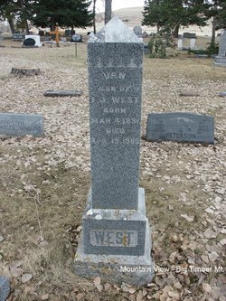
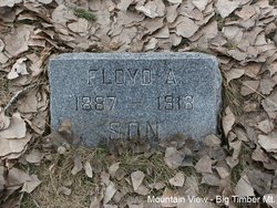
| Description | : | Floyd West a well known resident of this city, for many years proprietor of the Melville stage route, died Monday evening in his home in this city after a short illness with pnuemonia. Funeral services were held at the home yesterday afternoon, internment being in Mountain View. Deceased was born in Preston, ID., 31 years ago and came to Big Timber with his father, Ed West. 10 years ago he was married to Maggie Ellison, daughter of John Ellison, and the union three children were born. —Published Big Timber Pioneer Nov 7, 1918- |
frequently asked questions (FAQ):
-
Where is Floyd Alonza West's memorial?
Floyd Alonza West's memorial is located at: Stockton Memorial Cemetery, Stockton, Baldwin County, USA.
-
When did Floyd Alonza West death?
Floyd Alonza West death on 4 Nov 1918 in Big Timber, Sweet Grass County, Montana, USA
-
Where are the coordinates of the Floyd Alonza West's memorial?
Latitude: 30.9883003
Longitude: -87.8585968
Family Members:
Spouse
Children
Flowers:
Nearby Cemetories:
1. Stockton Memorial Cemetery
Stockton, Baldwin County, USA
Coordinate: 30.9883003, -87.8585968
2. Richerson Cemetery
Stockton, Baldwin County, USA
Coordinate: 31.0144005, -87.8602982
3. Vaughn Cemetery
Vaughn, Baldwin County, USA
Coordinate: 31.0312010, -87.8609040
4. Watson Family Cemetery
Baldwin County, USA
Coordinate: 31.0301369, -87.8390816
5. Robinson Cemetery
Stockton, Baldwin County, USA
Coordinate: 31.0402000, -87.8555000
6. Lancaster Cemetery
Baldwin County, USA
Coordinate: 31.0426120, -87.8494800
7. Dennis Family Cemetery
Baldwin County, USA
Coordinate: 30.9274078, -87.8495614
8. Bryars Family Cemetery
Stockton, Baldwin County, USA
Coordinate: 31.0665500, -87.8397100
9. New Life Baptist Church Cemetery
Bay Minette, Baldwin County, USA
Coordinate: 30.9469200, -87.7638500
10. Dean Cemetery
Rabun, Baldwin County, USA
Coordinate: 31.0031891, -87.7488632
11. New Providence Southern Baptist Church Cemetery
Rabun, Baldwin County, USA
Coordinate: 30.9967003, -87.7449036
12. Latham Methodist Church Cemetery
Latham, Baldwin County, USA
Coordinate: 31.0983658, -87.8300323
13. Guys Chapel United Methodist Church Cemetery
Rabun, Baldwin County, USA
Coordinate: 31.0272007, -87.7247009
14. Smiths Cemetery
Axis, Mobile County, USA
Coordinate: 30.9373380, -87.9913580
15. Hall Family Graveyard
Carpenter, Baldwin County, USA
Coordinate: 30.8616505, -87.8687973
16. Bay Minette Cemetery
Bay Minette, Baldwin County, USA
Coordinate: 30.8906002, -87.7596970
17. Gentry Cemetery
Baldwin County, USA
Coordinate: 31.0475006, -87.7236023
18. Stanmyer Cemetery
Bay Minette, Baldwin County, USA
Coordinate: 30.8770008, -87.7750015
19. Bluff Cemetery
Axis, Mobile County, USA
Coordinate: 30.9373250, -88.0053650
20. Cain Cemetery
Bay Minette, Baldwin County, USA
Coordinate: 30.8885994, -87.7446976
21. Saint Louis Baptist Church Cemetery
Axis, Mobile County, USA
Coordinate: 30.9206200, -88.0013300
22. Mount Nebo Baptists Church Cemetery
Stockton, Baldwin County, USA
Coordinate: 31.1290300, -87.8346800
23. Seymour Bluff Cemetery
Chastang, Mobile County, USA
Coordinate: 31.0255770, -88.0216580
24. Dyas Cemetery
Dyas, Baldwin County, USA
Coordinate: 30.9608652, -87.6909509


