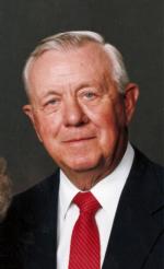
Floyd Dale Amon
| Birth | : | 27 Jun 1925 Holton, Jackson County, Kansas, USA |
| Death | : | 23 Jul 2010 Holton, Jackson County, Kansas, USA |
| Burial | : | Strong Community Cemetery, Sundridge, Parry Sound District, Canada |
| Coordinate | : | 45.7767448, -79.4004288 |
| Plot | : | Section JJ |
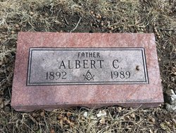
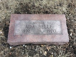
| Description | : | HOLTON- Floyd Dale Amon, 85, of Holton died Friday July 23, 2010 at his home. He was born June 27, 1925 in Holton, the son of Albert Charles and Ada Belle (Hoverstock) Amon. Floyd graduated from Holton High School in 1943 and entered the United States Army in 1949. After proudly serving his country for 35 years, he retired from the United States Army Reserves in 1985. Floyd was a farmer and stockman his entire life. He was a member of the American Legion Mary L. Bair Post #44 in Holton, a member of the Jackson County Livestock Association, served... Read More |
frequently asked questions (FAQ):
-
Where is Floyd Dale Amon's memorial?
Floyd Dale Amon's memorial is located at: Strong Community Cemetery, Sundridge, Parry Sound District, Canada.
-
When did Floyd Dale Amon death?
Floyd Dale Amon death on 23 Jul 2010 in Holton, Jackson County, Kansas, USA
-
Where are the coordinates of the Floyd Dale Amon's memorial?
Latitude: 45.7767448
Longitude: -79.4004288
Family Members:
Parent
Siblings
Flowers:
Nearby Cemetories:
1. Strong Community Cemetery
Sundridge, Parry Sound District, Canada
Coordinate: 45.7767448, -79.4004288
2. South River Cemetery
South River, Parry Sound District, Canada
Coordinate: 45.8359500, -79.3982400
3. Siloam Cemetery
South River, Parry Sound District, Canada
Coordinate: 45.8499800, -79.4176500
4. Zion Lutheran Deer Lake Cemetery
Parry Sound, Parry Sound District, Canada
Coordinate: 45.7932440, -79.5596210
5. Higher Heights Christian Fellowship Cemetery
South River, Parry Sound District, Canada
Coordinate: 45.8953070, -79.3786800
6. Chetwynd Cemetery
Burks Falls, Parry Sound District, Canada
Coordinate: 45.6182050, -79.3371300
7. Burks Falls Cemetery
Burks Falls, Parry Sound District, Canada
Coordinate: 45.6009200, -79.3979400
8. Chapman Community Cemetery
Chapman, Parry Sound District, Canada
Coordinate: 45.6943265, -79.6374739
9. Spence Community Cemetery
Spence, Parry Sound District, Canada
Coordinate: 45.6794395, -79.6414413
10. Union Cemetery
Trout Creek, Parry Sound District, Canada
Coordinate: 45.9833200, -79.3768000
11. Midlothian Memorial Cemetery
Midlothian, Parry Sound District, Canada
Coordinate: 45.5969800, -79.5654300
12. Royston Cemetery
Ryerson, Parry Sound District, Canada
Coordinate: 45.5632100, -79.4698000
13. Sacred Heart Cemetery
Trout Creek, Parry Sound District, Canada
Coordinate: 45.9979500, -79.3710000
14. Knox United Church Cemetery
Kearney, Parry Sound District, Canada
Coordinate: 45.5600000, -79.2111667
15. St Patrick's Roman Catholic Church Cemetery
Kearney, Parry Sound District, Canada
Coordinate: 45.5566347, -79.2183030
16. St. Mark's Anglican Cemetery
Emsdale, Parry Sound District, Canada
Coordinate: 45.5245350, -79.3161830
17. St. Gerard Roman Catholic Cemetery
McMurrich, Parry Sound District, Canada
Coordinate: 45.5012900, -79.4152300
18. Holiness Cemetery
Powassan, Parry Sound District, Canada
Coordinate: 46.0478900, -79.2822000
19. Ahmic Harbour Cemetery
Ahmic Harbour, Parry Sound District, Canada
Coordinate: 45.6623383, -79.7782211
20. Saint Pauls Cemetery
Sprucedale, Parry Sound District, Canada
Coordinate: 45.4903908, -79.4618149
21. Powassan Union Cemetery
Powassan, Parry Sound District, Canada
Coordinate: 46.0772500, -79.3875700
22. Saint Joseph’s Cemetery
Powassan, Parry Sound District, Canada
Coordinate: 46.0837400, -79.3906000
23. Barber Poineer Cemetery
Restoule, Parry Sound District, Canada
Coordinate: 46.0636100, -79.5771700
24. Golden Valley Cemetery
Golden Valley, Parry Sound District, Canada
Coordinate: 45.9251970, -79.8041630


