
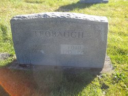
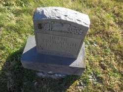
Fobie Trobaugh
| Birth | : | 8 Sep 1915 Clay County, Tennessee, USA |
| Death | : | 28 Oct 1951 Glasgow, Barren County, Kentucky, USA |
| Burial | : | Macedonia Cemetery, Moss, Clay County, USA |
| Coordinate | : | 36.5643997, -85.6110992 |
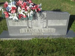
| Description | : | Kentucky Death Index, 1911-2000 Name: Folbie Trobaugh Death Date: 28 Oct 1951 Death Place: Barren Age: 36 Birth: Sept 8, 1915 Residence: Tenn Father: Hershell Troubough Mother: Mary Ann Strong Volume: 43 Certificate: 21488 Occupation: lumber business Cause of death: blow to abdomen by log train Burial: Massie Donnie Cemetery - Clay Co., TN. Home in 1920: Civil District 2, Clay, Tennessee Hershall Trobough 25 Mary A Trobough 29 Fowler Trobough 7 Fauby Trabaugh 4[4 2/12] James F Trabaugh 2[2 5/12] Renford Trabaugh 0[1/12] Home in 1930: District 1, Clay, Tennessee Hershel Trobough 37 Mary A Trobough 42 Fowler Trobough 16 Fobie Trobough 14 James F Trobough 12 Renford Trobough 10 Robert Trobough 8 Odell Trobough 6 Norman Trobough 1[1 4/12] Home in 1940: Clay, Tennessee Fobie Trobaugh... Read More |
frequently asked questions (FAQ):
-
Where is Fobie Trobaugh's memorial?
Fobie Trobaugh's memorial is located at: Macedonia Cemetery, Moss, Clay County, USA.
-
When did Fobie Trobaugh death?
Fobie Trobaugh death on 28 Oct 1951 in Glasgow, Barren County, Kentucky, USA
-
Where are the coordinates of the Fobie Trobaugh's memorial?
Latitude: 36.5643997
Longitude: -85.6110992
Family Members:
Parent
Spouse
Siblings
Children
Flowers:


Nearby Cemetories:
1. Strong Family Cemetery
Clay County, USA
Coordinate: 36.5690700, -85.6042600
2. McLerran Cemetery
Moss, Clay County, USA
Coordinate: 36.5790000, -85.5973000
3. Kendall Cemetery
Moss, Clay County, USA
Coordinate: 36.5672540, -85.6362650
4. Moss Cemetery
Moss, Clay County, USA
Coordinate: 36.5911210, -85.6214460
5. Eads-Denton Cemetery
Pine Hill, Clay County, USA
Coordinate: 36.5644207, -85.6503187
6. Odle Cemetery
Clay County, USA
Coordinate: 36.5966988, -85.6085968
7. Spear Family Cemetery
Moss, Clay County, USA
Coordinate: 36.5933200, -85.5876500
8. Meadows Cemetery
Clay County, USA
Coordinate: 36.5946999, -85.5875015
9. Smith Cemetery
Pine Hill, Clay County, USA
Coordinate: 36.5714930, -85.6568170
10. Liberty Church Cemetery
Boles, Clay County, USA
Coordinate: 36.6010850, -85.6496830
11. Dalton Cemetery
Arcott, Clay County, USA
Coordinate: 36.5429540, -85.5546170
12. Moore Cemetery
Moss, Clay County, USA
Coordinate: 36.6113400, -85.6374980
13. Walker Reecer Cemetery
Celina, Clay County, USA
Coordinate: 36.5746290, -85.5480270
14. New Hope Cemetery
Clay County, USA
Coordinate: 36.6021996, -85.5653000
15. Archibald Plumlee Cemetery
Pine Hill, Clay County, USA
Coordinate: 36.5203018, -85.5682983
16. Pricetown Cemetery
Clay County, USA
Coordinate: 36.5422500, -85.6750670
17. Willhoite-Curtis Cemetery
Tompkinsville, Monroe County, USA
Coordinate: 36.6182208, -85.6442948
18. Lester Brown Family Cemetery
Arcott, Clay County, USA
Coordinate: 36.5205700, -85.5547530
19. Jonestown Cemetery
Clay County, USA
Coordinate: 36.5619011, -85.6921997
20. McColgan Cemetery
Clay County, USA
Coordinate: 36.5163994, -85.5560989
21. Roberts Cemetery
Celina, Clay County, USA
Coordinate: 36.5066986, -85.5727997
22. Freedom Cemetery #2
Tompkinsville, Monroe County, USA
Coordinate: 36.6284060, -85.6289940
23. Plumlee Cemetery
Celina, Clay County, USA
Coordinate: 36.5694280, -85.5282830
24. Moore Cemetery #1
Moss, Clay County, USA
Coordinate: 36.6164920, -85.6636620