
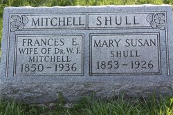
Frances Elizabeth Shull Mitchell
| Birth | : | 26 Nov 1849 Adair County, Missouri, USA |
| Death | : | 31 Aug 1937 Lancaster, Schuyler County, Missouri, USA |
| Burial | : | Massachusetts Veterans Memorial Cemetery, Winchendon, Worcester County, USA |
| Coordinate | : | 42.6851300, -72.0185200 |
| Description | : | widowed, daughter of Elege Shull and Amanda Cobb, wife of W.F. Mitchell d. cert 35433 indicates a birth date of November 26 as does the 2nd obituary ------------ Missouri Marriage Records, 1805-2002 Name: Frances Elizabeth Shull Marriage Date: 12 Mar 1907 Marriage Place: Lancaster, Schuyler, MO Registration Place: Schuyler, Missouri Spouse: William Francis Mitchell ------------ Frances Shull, daughter of Elledge and Amanda Shull, was born on a farm in Adair county, Mo., November 24, 1849. When a small child she came with her parents to Schuyler county where they settled on a farm near Lancaster. March 12, 1907, she was married to Dr. W.... Read More |
frequently asked questions (FAQ):
-
Where is Frances Elizabeth Shull Mitchell's memorial?
Frances Elizabeth Shull Mitchell's memorial is located at: Massachusetts Veterans Memorial Cemetery, Winchendon, Worcester County, USA.
-
When did Frances Elizabeth Shull Mitchell death?
Frances Elizabeth Shull Mitchell death on 31 Aug 1937 in Lancaster, Schuyler County, Missouri, USA
-
Where are the coordinates of the Frances Elizabeth Shull Mitchell's memorial?
Latitude: 42.6851300
Longitude: -72.0185200
Family Members:
Parent

Spouse
Siblings

Flowers:


Nearby Cemetories:
1. Massachusetts Veterans Memorial Cemetery
Winchendon, Worcester County, USA
Coordinate: 42.6851300, -72.0185200
2. Riverside Cemetery
Winchendon, Worcester County, USA
Coordinate: 42.6805992, -72.0263977
3. Calvary Cemetery
Winchendon, Worcester County, USA
Coordinate: 42.6805992, -72.0318985
4. Old Centre Burial Ground
Winchendon, Worcester County, USA
Coordinate: 42.6617012, -72.0366974
5. Robbins Cemetery
Rindge, Cheshire County, USA
Coordinate: 42.7266670, -72.0638890
6. Robbins Burial Ground
Rindge, Cheshire County, USA
Coordinate: 42.7268982, -72.0658035
7. Rand Cemetery
Rindge, Cheshire County, USA
Coordinate: 42.7350006, -72.0582962
8. Hillside Cemetery
Rindge, Cheshire County, USA
Coordinate: 42.7463000, -72.0063900
9. Wood Family Cemetery
Rindge, Cheshire County, USA
Coordinate: 42.7457040, -71.9859410
10. Meeting House Cemetery
Rindge, Cheshire County, USA
Coordinate: 42.7501200, -72.0096700
11. New Boston Cemetery
Winchendon, Worcester County, USA
Coordinate: 42.6306000, -72.0860977
12. Wilder Cemetery
Rindge, Cheshire County, USA
Coordinate: 42.7395400, -71.9404900
13. Greenlawn Cemetery
Templeton, Worcester County, USA
Coordinate: 42.6124992, -72.0708008
14. Meetinghouse Hill Cemetery
Ashburnham, Worcester County, USA
Coordinate: 42.6436900, -71.9176100
15. Fairbanks Cemetery
Ashburnham, Worcester County, USA
Coordinate: 42.6355220, -71.9236710
16. Cathedral of the Pines Cemetery
Rindge, Cheshire County, USA
Coordinate: 42.7749900, -71.9901800
17. New Cemetery
Ashburnham, Worcester County, USA
Coordinate: 42.6318400, -71.9137400
18. Saint Josephs Cemetery
Gardner, Worcester County, USA
Coordinate: 42.5922012, -72.0391998
19. Wildwood Cemetery
Gardner, Worcester County, USA
Coordinate: 42.5896988, -72.0306015
20. Saint Denis Cemetery
Ashburnham, Worcester County, USA
Coordinate: 42.6458015, -71.8985977
21. Saint Johns Cemetery
Gardner, Worcester County, USA
Coordinate: 42.5875015, -72.0207977
22. Notre Dame Cemetery
Gardner, Worcester County, USA
Coordinate: 42.5849991, -72.0222015
23. Crystal Lake Cemetery
Gardner, Worcester County, USA
Coordinate: 42.5833015, -71.9957962
24. Old Burying Ground
Gardner, Worcester County, USA
Coordinate: 42.5811800, -71.9867100