| Birth | : | 17 Nov 1921 Minatare, Scotts Bluff County, Nebraska, USA |
| Death | : | 24 Jun 2007 Lexington, Dawson County, Nebraska, USA |
| Burial | : | East Lawn Cemetery, Minatare, Scotts Bluff County, USA |
| Coordinate | : | 41.8591995, -103.5177994 |
| Plot | : | Section G, Plot 5 Deed# 428 |
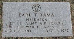
| Description | : | Frances I. Rama, 85, formerly of Minatare, Nebraska, passed away Sunday, June 24, 2007 at the Plum Creek Care Center in Lexington, Nebraska. The former Frances Klemke was born at home in Minatare on November 17, 1921, to Erich H. Klemke and Hazel (Vanatta) Klemke. After graduating high school in Minatare, Frances attended Colorado Women's College in Denver. She was married October 31, 1942 to Earl T. Rama at Yuma, Arizona. To this marriage was born four children, David, Judith, Alexi and Robert. Frances had been very active in panhandle stamp and coin clubs and was a long time member... Read More |
frequently asked questions (FAQ):
-
Where is Frances I Klemke Rama's memorial?
Frances I Klemke Rama's memorial is located at: East Lawn Cemetery, Minatare, Scotts Bluff County, USA.
-
When did Frances I Klemke Rama death?
Frances I Klemke Rama death on 24 Jun 2007 in Lexington, Dawson County, Nebraska, USA
-
Where are the coordinates of the Frances I Klemke Rama's memorial?
Latitude: 41.8591995
Longitude: -103.5177994
Family Members:
Parent
Spouse
Flowers:
Nearby Cemetories:
1. East Lawn Cemetery
Minatare, Scotts Bluff County, USA
Coordinate: 41.8591995, -103.5177994
2. Fairview Cemetery
Scottsbluff, Scotts Bluff County, USA
Coordinate: 41.8857994, -103.6536026
3. Saint Francis Episcopal Church Columbarium
Scottsbluff, Scotts Bluff County, USA
Coordinate: 41.8665000, -103.6617500
4. Creighton Valley Cemetery
Melbeta, Scotts Bluff County, USA
Coordinate: 41.7482300, -103.5580400
5. West Lawn Cemetery
Gering, Scotts Bluff County, USA
Coordinate: 41.8167000, -103.6849976
6. High Butte Cemetery
McGrew, Scotts Bluff County, USA
Coordinate: 41.7289009, -103.4353027
7. Sunset Memorial Park
Scottsbluff, Scotts Bluff County, USA
Coordinate: 41.8997002, -103.7166977
8. Bayard Cemetery
Bayard, Morrill County, USA
Coordinate: 41.7666910, -103.3236600
9. Pierre Didier Papin Gravesite
Gering, Scotts Bluff County, USA
Coordinate: 41.7353783, -103.6983490
10. Chimney Rock Cemetery
Morrill County, USA
Coordinate: 41.6991997, -103.3399963
11. Mitchell Valley Cemetery
Mitchell, Scotts Bluff County, USA
Coordinate: 41.8877983, -103.8311005
12. Pioneer Graves
Scotts Bluff County, USA
Coordinate: 41.8057785, -103.8303909
13. Morrill County Rural Burial Site
Bayard, Morrill County, USA
Coordinate: 41.7312100, -103.2353100
14. Mitchell Cemetery
Mitchell, Scotts Bluff County, USA
Coordinate: 41.9585991, -103.8214035
15. Angora Cemetery
Angora, Morrill County, USA
Coordinate: 41.8577995, -103.1306000
16. Snake Creek Cemetery
Box Butte County, USA
Coordinate: 42.0889015, -103.2742004
17. Caldwell Pioneer Graves
Scotts Bluff County, USA
Coordinate: 41.8911812, -103.9287087
18. Forest Lawn Cemetery
Morrill, Scotts Bluff County, USA
Coordinate: 41.9919014, -103.9128036
19. Chaulk Creek Cemetery
Harrisburg, Banner County, USA
Coordinate: 41.5496560, -103.3781240
20. Oregon Trail Memorial Park Cemetery
Bridgeport, Morrill County, USA
Coordinate: 41.6699982, -103.1449966
21. Caldwell Cemetery
Scotts Bluff County, USA
Coordinate: 41.8997002, -103.9768982
22. Harrisburg Cemetery
Banner County, USA
Coordinate: 41.5427010, -103.7158430
23. Kirk Cemetery
Harrisburg, Banner County, USA
Coordinate: 41.5103480, -103.4653220
24. Redington Cemetery
Redington, Morrill County, USA
Coordinate: 41.5697760, -103.2425540


