Frances Myrene Tingwald Hamman
| Birth | : | 10 Jul 1918 Ogden, Boone County, Iowa, USA |
| Death | : | 8 Aug 2015 Boone, Boone County, Iowa, USA |
| Burial | : | St Nicholas Churchyard, Great Yarmouth, Great Yarmouth Borough, England |
| Coordinate | : | 52.6109500, 1.7269100 |
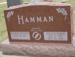
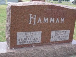
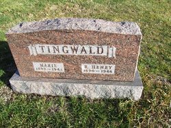
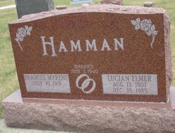
| Inscription | : | Daughter of R Henry & Marie Cook Tingwald, married June 2 1940 |
| Description | : | Frances M. Hamman, 97, of 1903 Longwood Avenue in Woodward, Iowa passed away at the Boone County Hospital in Boone on Saturday afternoon, August 8, 2015.She was born on July 10, 1918 in Ogden, Iowa the daughter of R. Henry and Marie (Cook) Tingwald.On June 2, 1940, she married Lucian E. Hamman at the Woodward United Methodist Church in Woodward.Frances graduated in 1935 from Ogden High School with a normal training certificate and taught in Boone County rural schools for 10 years. In 1967, she received her Associate Arts Degree from Boone Junior College and graduated in 1968 from Drake... Read More |
frequently asked questions (FAQ):
-
Where is Frances Myrene Tingwald Hamman's memorial?
Frances Myrene Tingwald Hamman's memorial is located at: St Nicholas Churchyard, Great Yarmouth, Great Yarmouth Borough, England.
-
When did Frances Myrene Tingwald Hamman death?
Frances Myrene Tingwald Hamman death on 8 Aug 2015 in Boone, Boone County, Iowa, USA
-
Where are the coordinates of the Frances Myrene Tingwald Hamman's memorial?
Latitude: 52.6109500
Longitude: 1.7269100
Family Members:
Parent
Spouse
Siblings
Flowers:
Nearby Cemetories:
1. St Nicholas Churchyard
Great Yarmouth, Great Yarmouth Borough, England
Coordinate: 52.6109500, 1.7269100
2. Dissenters' Grave Yard
Great Yarmouth, Great Yarmouth Borough, England
Coordinate: 52.6088420, 1.7279481
3. White Friars Carmelite Priory
Great Yarmouth, Great Yarmouth Borough, England
Coordinate: 52.6079960, 1.7233900
4. Kitchener Road Cemetery
Great Yarmouth, Great Yarmouth Borough, England
Coordinate: 52.6125100, 1.7333200
5. Great Yarmouth New Cemetery
Great Yarmouth, Great Yarmouth Borough, England
Coordinate: 52.6151000, 1.7335100
6. Colby Gate Jewish Burial Ground
Great Yarmouth, Great Yarmouth Borough, England
Coordinate: 52.6014625, 1.7310622
7. Black Friars Priory
Great Yarmouth, Great Yarmouth Borough, England
Coordinate: 52.6003760, 1.7285340
8. Caister Road Roman Catholic Cemetery
Great Yarmouth, Great Yarmouth Borough, England
Coordinate: 52.6332800, 1.7284900
9. Saint Andrew Churchyard
Gorleston-on-Sea, Great Yarmouth Borough, England
Coordinate: 52.5788550, 1.7249070
10. Gorleston Cemetery
Gorleston-on-Sea, Great Yarmouth Borough, England
Coordinate: 52.5786850, 1.7171760
11. Caister-on-Sea Cemetery
Caister-on-Sea, Great Yarmouth Borough, England
Coordinate: 52.6492100, 1.7248600
12. Holy Trinity Churchyard
Caister-on-Sea, Great Yarmouth Borough, England
Coordinate: 52.6494670, 1.7239940
13. Magdalen Lawn Cemetery
Great Yarmouth, Great Yarmouth Borough, England
Coordinate: 52.5719600, 1.7073100
14. Gorleston Crematorium
Gorleston-on-Sea, Great Yarmouth Borough, England
Coordinate: 52.5718100, 1.7044000
15. St Nicholas Churchyard
Bradwell, Great Yarmouth Borough, England
Coordinate: 52.5748650, 1.6928610
16. Caister Cemetery
Caister-on-Sea, Great Yarmouth Borough, England
Coordinate: 52.6536300, 1.7231200
17. St Peter and St Paul Churchyard
Burgh Castle, Great Yarmouth Borough, England
Coordinate: 52.5861230, 1.6542990
18. St. Peter and St. Paul Churchyard
Mautby, Great Yarmouth Borough, England
Coordinate: 52.6521700, 1.6661000
19. Ss Peter and Paul Churchyard
Mautby, Great Yarmouth Borough, England
Coordinate: 52.6523100, 1.6659790
20. All Saints Churchyard
Belton, Great Yarmouth Borough, England
Coordinate: 52.5674970, 1.6662540
21. St Margaret Churchyard
Ormesby St Margaret, Great Yarmouth Borough, England
Coordinate: 52.6705421, 1.6947782
22. St. Peter and St. Paul Churchyard
Runham, Great Yarmouth Borough, England
Coordinate: 52.6395200, 1.6344400
23. All Saints Churchyard
Filby, Great Yarmouth Borough, England
Coordinate: 52.6604730, 1.6495130
24. All Saints Churchyard
Filby, Great Yarmouth Borough, England
Coordinate: 52.6608250, 1.6494520


