
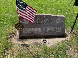
Frances Rena “Fran” Bleeker Black
| Birth | : | 6 Jul 1923 Clay County, Iowa, USA |
| Death | : | 19 May 2009 Spencer, Clay County, Iowa, USA |
| Burial | : | Riverside Cemetery, Spencer, Clay County, USA |
| Coordinate | : | 43.1441994, -95.1671982 |
| Description | : | Francis Rena Black the daughter of Edward and Sophie (Kromminga) Bleeker was born July 26 1923 on a farm north of Everly, Ia. She was raised on a farm north of Everly and attened the County school that was on the north end of the family farm. She moved to Spencer in 1937 and attended high school. During high school,she worked at Carolls Bakery. fran married Donald G. Black on July 26, 1944, in South Sioux City NE. Following thier marriage they continued to live in Spencer where Fran worked at Montgomery Ward for 7 years and latter as as a... Read More |
frequently asked questions (FAQ):
-
Where is Frances Rena “Fran” Bleeker Black's memorial?
Frances Rena “Fran” Bleeker Black's memorial is located at: Riverside Cemetery, Spencer, Clay County, USA.
-
When did Frances Rena “Fran” Bleeker Black death?
Frances Rena “Fran” Bleeker Black death on 19 May 2009 in Spencer, Clay County, Iowa, USA
-
Where are the coordinates of the Frances Rena “Fran” Bleeker Black's memorial?
Latitude: 43.1441994
Longitude: -95.1671982
Family Members:
Parent

Spouse

Siblings
Flowers:


Nearby Cemetories:
1. Riverside Cemetery
Spencer, Clay County, USA
Coordinate: 43.1441994, -95.1671982
2. Dewey Readmore Books Memorial
Spencer, Clay County, USA
Coordinate: 43.1403999, -95.1443024
3. North Lawn Cemetery
Spencer, Clay County, USA
Coordinate: 43.1600000, -95.1470000
4. Evergreen Cemetery
Clay County, USA
Coordinate: 43.2052994, -95.2086029
5. Fairview Cemetery
Clay County, USA
Coordinate: 43.1899986, -95.0800018
6. Swedish Lutheran Cemetery
Royal, Clay County, USA
Coordinate: 43.0683000, -95.2350000
7. Dickens Cemetery
Dickens, Clay County, USA
Coordinate: 43.1280000, -95.0155000
8. Rosehill Cemetery
Clay County, USA
Coordinate: 43.0368996, -95.0919037
9. Lone Tree Cemetery
Everly, Clay County, USA
Coordinate: 43.1411018, -95.3347015
10. Little Sioux Lutheran Cemetery
Milford, Dickinson County, USA
Coordinate: 43.2702065, -95.2109528
11. First Reformed Cemetery
Clay County, USA
Coordinate: 43.2399500, -95.2889000
12. Lincoln Cemetery
Rossie, Clay County, USA
Coordinate: 43.0111008, -95.2313995
13. Willow Creek Cemetery
Royal, Clay County, USA
Coordinate: 43.0214005, -95.2885971
14. Liberty Cemetery
Greenville, Clay County, USA
Coordinate: 42.9897003, -95.1417007
15. Clay Center Cemetery
Royal, Clay County, USA
Coordinate: 43.0410995, -95.3272018
16. Milford Cemetery
Milford, Dickinson County, USA
Coordinate: 43.3092003, -95.1481018
17. TriMello Cemetery
Royal, Clay County, USA
Coordinate: 43.0682983, -95.3728027
18. Logan Township Cemetery
Clay County, USA
Coordinate: 43.0489006, -94.9747009
19. Zion Methodist Cemetery
Clay County, USA
Coordinate: 42.9808006, -95.2497025
20. Calvary Cemetery
Milford, Dickinson County, USA
Coordinate: 43.3213997, -95.1688995
21. Fanny Fern Cemetery
Clay County, USA
Coordinate: 42.9530983, -95.1607971
22. Crown Hill Cemetery
Ruthven, Palo Alto County, USA
Coordinate: 43.1328011, -94.8878021
23. Calvary Cemetery
Ruthven, Palo Alto County, USA
Coordinate: 43.1314011, -94.8869019
24. Westport Cemetery
Dickinson County, USA
Coordinate: 43.3130989, -95.3289032