
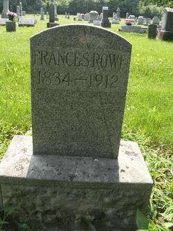
Frances Shank Rowe
| Birth | : | 20 Sep 1834 Virginia, USA |
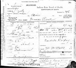
| Death | : | 24 Apr 1912 New Goshen, Vigo County, Indiana, USA |
| Burial | : | St. Maria Goretti Catholic Cemetery, Lorne, Restigouche County, Canada |
| Coordinate | : | 47.8720790, -66.1266760 |
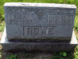
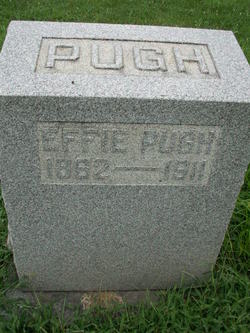
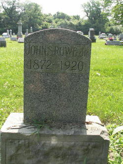
| Description | : | Frances was the daughter of Jacob Shank. On Apr. 12, 1855 she married John Rowe and they became the parents of 4 children: Harvey D., Lovina, Effie and John S., Jr. |
frequently asked questions (FAQ):
-
Where is Frances Shank Rowe's memorial?
Frances Shank Rowe's memorial is located at: St. Maria Goretti Catholic Cemetery, Lorne, Restigouche County, Canada.
-
When did Frances Shank Rowe death?
Frances Shank Rowe death on 24 Apr 1912 in New Goshen, Vigo County, Indiana, USA
-
Where are the coordinates of the Frances Shank Rowe's memorial?
Latitude: 47.8720790
Longitude: -66.1266760
Family Members:
Spouse
Children
Flowers:


Nearby Cemetories:
1. St. Maria Goretti Catholic Cemetery
Lorne, Restigouche County, Canada
Coordinate: 47.8720790, -66.1266760
2. St. Joseph's Cemetery
Nash Creek, Restigouche County, Canada
Coordinate: 47.9212200, -66.0814300
3. Saint Gabriel's Cemetery
Jacquet River, Restigouche County, Canada
Coordinate: 47.9156900, -66.0165100
4. Our Lady of Visitation Cemetery
Benjamin River, Restigouche County, Canada
Coordinate: 47.9608470, -66.1677440
5. The Meeting House Cemetery
Jacquet River, Restigouche County, Canada
Coordinate: 47.9179700, -66.0001400
6. New Mills Cemetery
New Mills, Restigouche County, Canada
Coordinate: 47.9682730, -66.1863330
7. Dalhousie Riverview Cemetery Extension
Dalhousie, Restigouche County, Canada
Coordinate: 47.9687720, -66.1871800
8. Old Pioneer Protestant Church
Belledune River, Restigouche County, Canada
Coordinate: 47.9102427, -65.8795417
9. Saint John Evangelist RC Cemetery
Belledune, Restigouche County, Canada
Coordinate: 47.9059870, -65.8446690
10. St Francois-Xavier Cemetery
Charlo, Restigouche County, Canada
Coordinate: 48.0033690, -66.3383130
11. St Luke's United Cemetery
Belledune, Gloucester County, Canada
Coordinate: 47.8871900, -65.8130800
12. Saint Luke's United Cemetery
Belledune River, Restigouche County, Canada
Coordinate: 47.8784770, -65.8025750
13. Old Carleton Cemetery
Carleton, Gaspesie-Iles-de-la-Madeleine Region, Canada
Coordinate: 48.1011100, -66.1086890
14. Crypte de l'église de Carleton-sur-Mer
Carleton-sur-Mer, Gaspesie-Iles-de-la-Madeleine Region, Canada
Coordinate: 48.1016010, -66.1082120
15. Carleton-sur-Mer Cimetière du Saint Joseph
Carleton-sur-Mer, Gaspesie-Iles-de-la-Madeleine Region, Canada
Coordinate: 48.1059810, -66.1077940
16. Eel River Crossing Cemetery
Eel River Crossing, Restigouche County, Canada
Coordinate: 48.0168600, -66.4195600
17. Cimetière (ancien) de St-Omer (Carleton-sur-Mer)
Carleton-sur-Mer, Gaspesie-Iles-de-la-Madeleine Region, Canada
Coordinate: 48.1106660, -66.2205170
18. Saint-Jean-Baptiste Cemetery
Dalhousie, Restigouche County, Canada
Coordinate: 48.0494977, -66.3854513
19. Cimetière (nouveau) de St-Omer (Carleton-sur-Mer)
Carleton-sur-Mer, Gaspesie-Iles-de-la-Madeleine Region, Canada
Coordinate: 48.1126800, -66.2185330
20. New Carleton Cemetery
Carleton-sur-Mer, Gaspesie-Iles-de-la-Madeleine Region, Canada
Coordinate: 48.1126800, -66.2185330
21. Saint-Jean-Baptiste Cemetery
Dalhousie, Restigouche County, Canada
Coordinate: 48.0624667, -66.3675414
22. Dalhousie Cemetery
Dalhousie, Restigouche County, Canada
Coordinate: 48.0654500, -66.3682800
23. Riverside Cemetery
Dalhousie, Restigouche County, Canada
Coordinate: 48.0653900, -66.3685600
24. Saint Mary's Anglican Churchyard
Dalhousie, Restigouche County, Canada
Coordinate: 48.0655480, -66.3756800