
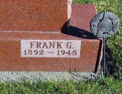

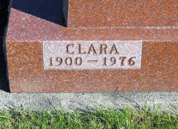
Frank G. Schreck
| Birth | : | 12 Oct 1892 Dedham, Carroll County, Iowa, USA |
| Death | : | 26 Jul 1948 Carroll, Carroll County, Iowa, USA |
| Burial | : | Sacred Heart Cemetery, Templeton, Carroll County, USA |
| Coordinate | : | 41.9138746, -94.9460994 |
| Description | : | Carroll Times Herald, July 26, 1948 DEATH CLAIMS FRANK SCHRECK OF TEMPLETON Former Carroll County Banker Dies at Hospital; Rites Thursday Templeton--Frank G. Schreck, 55, of Templeton, died at 1:50 this morning at St. Anthony hospital in Carroll as the result of a heart attack suffered July 1. Solemn requiem mass will be read at the funeral services, to be held at Sacred Heart church here at 9:30 Thursday morning. Burial will be in the parish cemetery, with nephews of Mr. Schreck serving as pallbearers. The body will rest at the family home until the final rites. The Rosary led by the Very Rev. F.P.... Read More |
frequently asked questions (FAQ):
-
Where is Frank G. Schreck's memorial?
Frank G. Schreck's memorial is located at: Sacred Heart Cemetery, Templeton, Carroll County, USA.
-
When did Frank G. Schreck death?
Frank G. Schreck death on 26 Jul 1948 in Carroll, Carroll County, Iowa, USA
-
Where are the coordinates of the Frank G. Schreck's memorial?
Latitude: 41.9138746
Longitude: -94.9460994
Family Members:
Parent

Spouse
Siblings
Flowers:


Nearby Cemetories:
1. Sacred Heart Cemetery
Templeton, Carroll County, USA
Coordinate: 41.9138746, -94.9460994
2. Elba Cemetery
Templeton, Carroll County, USA
Coordinate: 41.9068985, -94.9131012
3. Sacred Heart Cemetery
Manning, Carroll County, USA
Coordinate: 41.9132500, -95.0540000
4. Gray Cemetery
Gray, Audubon County, USA
Coordinate: 41.8414001, -94.9946976
5. Manning Cemetery
Manning, Carroll County, USA
Coordinate: 41.8990000, -95.0620000
6. Holy Angels Cemetery
Carroll County, USA
Coordinate: 42.0014000, -94.9141998
7. Cameron Cemetery
Audubon County, USA
Coordinate: 41.8236008, -94.9167023
8. Dedham Cemetery
Dedham, Carroll County, USA
Coordinate: 41.8993988, -94.8225021
9. Saint Josephs Cemetery
Dedham, Carroll County, USA
Coordinate: 41.8993988, -94.8210983
10. Saint Augustine Cemetery
Halbur, Carroll County, USA
Coordinate: 42.0066986, -94.9744034
11. Lincoln Township Cemetery
Gray, Audubon County, USA
Coordinate: 41.8198130, -95.0154970
12. Saint Marys Catholic Cemetery
Willey, Carroll County, USA
Coordinate: 41.9783363, -94.8212204
13. Iowa Township Cemetery
Aspinwall, Crawford County, USA
Coordinate: 41.9216995, -95.1113968
14. McCurdy Cemetery
Carroll County, USA
Coordinate: 41.9403000, -94.7649994
15. Viola Center Cemetery
Viola Center, Audubon County, USA
Coordinate: 41.8236008, -94.8016968
16. Old Carrollton Cemetery
Carrollton, Carroll County, USA
Coordinate: 41.9233017, -94.7403030
17. Mount Olivet Cemetery
Carroll, Carroll County, USA
Coordinate: 42.0536340, -94.8595510
18. Carroll City Cemetery
Carroll, Carroll County, USA
Coordinate: 42.0560963, -94.8599856
19. Hayes Township Cemetery
Westside, Crawford County, USA
Coordinate: 42.0083199, -95.1216583
20. Luccocks Grove Cemetery
Audubon County, USA
Coordinate: 41.7619019, -94.8653030
21. Douglas Township Cemetery
Audubon County, USA
Coordinate: 41.7611008, -95.0282974
22. Oak Hill Cemetery
Coon Rapids, Carroll County, USA
Coordinate: 41.9053001, -94.7200012
23. Westside Cemetery
Westside, Crawford County, USA
Coordinate: 42.0602989, -95.0922012
24. Saint Francis Cemetery
Maple River, Carroll County, USA
Coordinate: 42.0969009, -94.9372025