

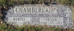
Frank Henry Chamberlain
| Birth | : | 19 Apr 1890 Minnesota, USA |
| Death | : | 20 Oct 1972 Big Sandy, Chouteau County, Montana, USA |
| Burial | : | Big Sandy Cemetery, Big Sandy, Chouteau County, USA |
| Coordinate | : | 48.1801170, -110.1207500 |
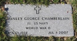
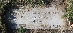
| Description | : | The following provided by Find A Grave contributor "Cara": Great Falls Tribune (MT), 22 Oct 1972 Big Sandy--Frank Henry Chamberlain, 82, died Friday in Big Sandy. Services will be held Tuesday at 10 a.m at the Big Sandy Catholic church. Burial will be in Big Sandy cemetery. Frank was born in Minnesota, where he was a farmer and timber worker. He married Myrtle Skoglund March 17, 1923. He came to Big Sandy in 1963. Survivors include sons, Stanley of Loma and Delbert of Big Sandy; daughters, Mildred Almndinger of Heins, Minn., Maye Chilgren of Junction City, Ore.,... Read More |
frequently asked questions (FAQ):
-
Where is Frank Henry Chamberlain's memorial?
Frank Henry Chamberlain's memorial is located at: Big Sandy Cemetery, Big Sandy, Chouteau County, USA.
-
When did Frank Henry Chamberlain death?
Frank Henry Chamberlain death on 20 Oct 1972 in Big Sandy, Chouteau County, Montana, USA
-
Where are the coordinates of the Frank Henry Chamberlain's memorial?
Latitude: 48.1801170
Longitude: -110.1207500
Family Members:
Spouse
Children
Flowers:


Nearby Cemetories:
1. Big Sandy Cemetery
Big Sandy, Chouteau County, USA
Coordinate: 48.1801170, -110.1207500
2. Box Elder Cemetery
Box Elder, Hill County, USA
Coordinate: 48.3274000, -110.0095000
3. Kenilworth Cemetery
Chouteau County, USA
Coordinate: 48.2192001, -110.4188995
4. Rocky Boy Cemetery
Rocky Boy, Hill County, USA
Coordinate: 48.2572410, -109.7923690
5. Rocky Boy Gravel Cemetery
Rocky Boy, Hill County, USA
Coordinate: 48.2427720, -109.7596500
6. Cottonwood Lutheran Church Cemetery
Havre, Hill County, USA
Coordinate: 48.4545000, -110.1748000
7. Gildford Hill County Cemetery
Gildford, Hill County, USA
Coordinate: 48.5778008, -110.2957993
8. Clear Lake Cemetery
Chouteau County, USA
Coordinate: 47.7731018, -110.2514038
9. Hingham Union Cemetery
Hingham, Hill County, USA
Coordinate: 48.5601570, -110.4178980
10. Sunset Garden Park
Havre, Hill County, USA
Coordinate: 48.5531006, -109.8019028
11. Graceville Cemetery
Chouteau County, USA
Coordinate: 47.7505989, -110.0875015
12. Hungry Hollow Cemetery
Blaine County, USA
Coordinate: 48.2103004, -109.4677963
13. Highland Cemetery
Havre, Hill County, USA
Coordinate: 48.5463982, -109.6900024
14. Mount Hope Cemetery
Havre, Hill County, USA
Coordinate: 48.5540000, -109.7050000
15. Calvary Cemetery
Havre, Hill County, USA
Coordinate: 48.5457000, -109.6883000
16. Rudyard Cemetery
Rudyard, Hill County, USA
Coordinate: 48.5659500, -110.5390000
17. Riverside Cemetery
Fort Benton, Chouteau County, USA
Coordinate: 47.8402330, -110.6408830
18. Old Shep Gravesite
Fort Benton, Chouteau County, USA
Coordinate: 47.8369000, -110.6557000
19. Milk River Valley Church Graveyard
Hill County, USA
Coordinate: 48.6787180, -110.2261080
20. Museum of the Upper Missouri
Fort Benton, Chouteau County, USA
Coordinate: 47.8207000, -110.6642000
21. Inverness Cemetery
Hill County, USA
Coordinate: 48.5531340, -110.6688450
22. Grainbelt Cemetery
Hill County, USA
Coordinate: 48.6828003, -109.8657990
23. Montague Cemetery
Chouteau County, USA
Coordinate: 47.6783000, -110.4670000
24. North Havre Lutheran Church Graveyard (Defunct)
Havre, Hill County, USA
Coordinate: 48.6538903, -109.6815870