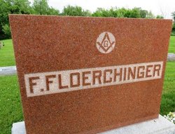
Frank J Floerchinger
| Birth | : | 14 Oct 1884 Iowa, USA |
| Death | : | 1 Sep 1950 Cameron, Milam County, Texas, USA |
| Burial | : | Escott Cemetery, Escott, Leeds and Grenville United Counties, Canada |
| Coordinate | : | 44.4403740, -75.9378900 |
| Description | : | Newspaper: Unknown Posted: 1956 Former Resident Dies in Collision Victor: Frank Floerchinger, of West Branch, former Iowa County man, was fatally injured and Mrs. Floerchinger seriously hurt when their automobile was struck by a truck at Cameron, Texas, Friday. Mr. Floerchinger suffered a broken back, broken neck and a punctured lung and lived only two hours after the crash. Funeral services were held at the Methodist Church in West Branch Tuesday afternoon. Mrs. Floerchinger was brought in an ambulance to an Iowa City hospital, where she is recovering from a possible fractured hip and other injuries. The Floerchingers are believed... Read More |
frequently asked questions (FAQ):
-
Where is Frank J Floerchinger's memorial?
Frank J Floerchinger's memorial is located at: Escott Cemetery, Escott, Leeds and Grenville United Counties, Canada.
-
When did Frank J Floerchinger death?
Frank J Floerchinger death on 1 Sep 1950 in Cameron, Milam County, Texas, USA
-
Where are the coordinates of the Frank J Floerchinger's memorial?
Latitude: 44.4403740
Longitude: -75.9378900
Family Members:
Spouse
Children
Flowers:
Nearby Cemetories:
1. Escott Cemetery
Escott, Leeds and Grenville United Counties, Canada
Coordinate: 44.4403740, -75.9378900
2. Union Cemetery
Lansdowne, Leeds and Grenville United Counties, Canada
Coordinate: 44.4335300, -75.9864900
3. Buell Cemetery
Rockport, Leeds and Grenville United Counties, Canada
Coordinate: 44.4120000, -75.9051940
4. LaRue Family Cemetery
Escott, Leeds and Grenville United Counties, Canada
Coordinate: 44.4314860, -75.8859600
5. Old McNickle Cemetery
Holland, Leeds and Grenville United Counties, Canada
Coordinate: 44.4040500, -75.9574670
6. Warren Burial Site
Rockfield, Leeds and Grenville United Counties, Canada
Coordinate: 44.4795030, -75.9478100
7. Grenadier Island Cemetery
Front of Escott, Leeds and Grenville United Counties, Canada
Coordinate: 44.4134660, -75.8812830
8. Ruttle-Warburton Cemetery
Lansdowne, Leeds and Grenville United Counties, Canada
Coordinate: 44.4662366, -76.0087640
9. Hunt Family Cemetery
Rockport, Leeds and Grenville United Counties, Canada
Coordinate: 44.3815510, -75.9361480
10. Rockport Protestant Cemetery Old
Rockport, Leeds and Grenville United Counties, Canada
Coordinate: 44.3812890, -75.9370750
11. Saint Brendans Roman Catholic Cemetery
Rockport, Leeds and Grenville United Counties, Canada
Coordinate: 44.3807870, -75.9363580
12. Rockport Protestant Cemetery New
Rockport, Leeds and Grenville United Counties, Canada
Coordinate: 44.3800170, -75.9387340
13. Mallorytown Cemetery
Mallorytown, Leeds and Grenville United Counties, Canada
Coordinate: 44.4837420, -75.8727320
14. Dulcemaine Cemetery
Dulcemaine, Leeds and Grenville United Counties, Canada
Coordinate: 44.4480110, -76.0434560
15. Saint Patrick's Roman Catholic Cemetery
Lansdowne, Leeds and Grenville United Counties, Canada
Coordinate: 44.4265600, -76.0520200
16. Saint Luke's Cemetery
Ballycanoe, Leeds and Grenville United Counties, Canada
Coordinate: 44.5328400, -75.9076700
17. Caintown Cemetery
Caintown, Leeds and Grenville United Counties, Canada
Coordinate: 44.5269760, -75.8814680
18. Lansdowne Cemetery
Ebenezer, Leeds and Grenville United Counties, Canada
Coordinate: 44.3852740, -76.0507110
19. Walton Street Cemetery
Alexandria Bay, Jefferson County, USA
Coordinate: 44.3375000, -75.9127900
20. Sand Bay Cemetery
Sand Bay Corner, Leeds and Grenville United Counties, Canada
Coordinate: 44.4637600, -76.0830400
21. Church Street Cemetery
Alexandria Bay, Jefferson County, USA
Coordinate: 44.3308300, -75.9136100
22. Saint Cyril's Cemetery
Alexandria Bay, Jefferson County, USA
Coordinate: 44.3300018, -75.9085999
23. Highland Park Cemetery
Alexandria Bay, Jefferson County, USA
Coordinate: 44.3294400, -75.9084800
24. Barnes Settlement Cemetery
Alexandria Bay, Jefferson County, USA
Coordinate: 44.3405991, -75.8463974


