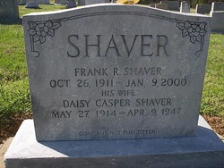
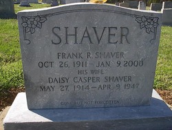
Frank Ramsey “Pop” Shaver
| Birth | : | 26 Oct 1911 Rowan County, North Carolina, USA |
| Death | : | 9 Jan 2000 Salisbury, Rowan County, North Carolina, USA |
| Burial | : | Hazel Cemetery, Bell Buckle, Bedford County, USA |
| Coordinate | : | 35.5835991, -86.3581009 |
| Plot | : | Row 29 |
| Description | : | Frank "Pop" Ramsey Shaver, 88, Salisbury, died Sunday (Jan. 9, 2000) at Rowan Regional Medical Center after a period of declining health. Born Oct. 26, 1911, in Rowan County, Mr. Shaver, the son of the late Mack and Lillie Arey Shaver, was educated in the Rowan County schools. He retired in 1974 after 37 years with North Carolina Finishing Co., where he had worked in the dye house. He was a member of St. Matthews Lutheran Church. He was preceded in death by his first wife, Daisy Casper Shaver, his second wife, Annie Lee Lane Shaver, and his third wife, Josephine Leonard... Read More |
frequently asked questions (FAQ):
-
Where is Frank Ramsey “Pop” Shaver's memorial?
Frank Ramsey “Pop” Shaver's memorial is located at: Hazel Cemetery, Bell Buckle, Bedford County, USA.
-
When did Frank Ramsey “Pop” Shaver death?
Frank Ramsey “Pop” Shaver death on 9 Jan 2000 in Salisbury, Rowan County, North Carolina, USA
-
Where are the coordinates of the Frank Ramsey “Pop” Shaver's memorial?
Latitude: 35.5835991
Longitude: -86.3581009
Family Members:
Parent
Spouse
Siblings
Flowers:
Nearby Cemetories:
1. Old Salem Cemetery
Bell Buckle, Bedford County, USA
Coordinate: 35.5793991, -86.3569031
2. Peacock Cemetery
Bell Buckle, Bedford County, USA
Coordinate: 35.5900002, -86.3538971
3. Cortner Cemetery
Bell Buckle, Bedford County, USA
Coordinate: 35.5778008, -86.3666992
4. Norvell Cemetery
Bell Buckle, Bedford County, USA
Coordinate: 35.5856018, -86.3469009
5. Wallis Cemetery
Bell Buckle, Bedford County, USA
Coordinate: 35.5633011, -86.3711014
6. Arnold Cemetery
Bell Buckle, Bedford County, USA
Coordinate: 35.5606003, -86.3516998
7. Sutton Cemetery
Bell Buckle, Bedford County, USA
Coordinate: 35.5639000, -86.3858032
8. Dial Cemetery
Bell Buckle, Bedford County, USA
Coordinate: 35.5964012, -86.3933029
9. Cross Roads Church of Christ Cemetery
Bell Buckle, Bedford County, USA
Coordinate: 35.5985985, -86.3938980
10. Bigham Cemetery
Bell Buckle, Bedford County, USA
Coordinate: 35.5868988, -86.3989029
11. Beachboard Cemetery
Bedford County, USA
Coordinate: 35.6239014, -86.3516998
12. Bates-Finch-Muse Cemetery
Bedford County, USA
Coordinate: 35.5574989, -86.3035965
13. Bingham Cemetery
Fosterville, Rutherford County, USA
Coordinate: 35.6288986, -86.3996964
14. Bell Cemetery
Deason, Bedford County, USA
Coordinate: 35.5999985, -86.4250031
15. Bingham Hiltop Plot
Bell Buckle, Bedford County, USA
Coordinate: 35.6425800, -86.3719500
16. Kelley Cemetery
Bedford, Bedford County, USA
Coordinate: 35.6356265, -86.3194374
17. Erwin Slave Cemetery
Bedford County, USA
Coordinate: 35.5746994, -86.4328003
18. Bigham Roadside Plot
Bell Buckle, Bedford County, USA
Coordinate: 35.6469400, -86.3604800
19. Bigham Cemetery
Bell Buckle, Bedford County, USA
Coordinate: 35.6481018, -86.3600006
20. Cleveland Cemetery
Bedford County, USA
Coordinate: 35.5313988, -86.3114014
21. New Hope Cemetery
Fairfield, Bedford County, USA
Coordinate: 35.5631000, -86.2828000
22. Espy Family Cemetery
Christiana, Rutherford County, USA
Coordinate: 35.6517810, -86.3576360
23. Gilmore Cemetery
Fosterville, Rutherford County, USA
Coordinate: 35.6446991, -86.3993988
24. Houston-Whitworth Cemetery
Deason, Bedford County, USA
Coordinate: 35.5844002, -86.4443970


