


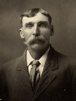
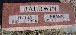
Frank Thomas Baldwin
| Birth | : | 19 Mar 1887 Holden, Johnson County, Missouri, USA |
| Death | : | 17 Aug 1973 Verdigre, Knox County, Nebraska, USA |
| Burial | : | Stanton Cemetery, Stanton, Stanton County, USA |
| Coordinate | : | 41.9599991, -97.2121964 |
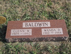
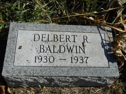
| Description | : | Frank is the son of William Elias & Bridget Biddy (Sullivan) Baldwin. Frank married Louisa Augusta Bertha Stark on January 3, 1909 in West Point, Nebraska. Frank and Louisa are the parents of: ~Glenn William b. October 18, 1909 d. July 15, 1992 ~Elmer Frank b. February 7, 1911 d. November 18, 1985 ~Leona Dorothy b. March 7, 1911 d. June 27, 1994 ~Flossie Lucille b. June 16, 1914 d. August 30, 1990 ~Gertrude b. January 28, 1916 d. September 19, 1918 ~Ralph Charles b. June 14, 1919 d. May 28, 1991 ~Mabel Dora b. October 15,... Read More |
frequently asked questions (FAQ):
-
Where is Frank Thomas Baldwin's memorial?
Frank Thomas Baldwin's memorial is located at: Stanton Cemetery, Stanton, Stanton County, USA.
-
When did Frank Thomas Baldwin death?
Frank Thomas Baldwin death on 17 Aug 1973 in Verdigre, Knox County, Nebraska, USA
-
Where are the coordinates of the Frank Thomas Baldwin's memorial?
Latitude: 41.9599991
Longitude: -97.2121964
Family Members:
Parent
Spouse
Siblings


Children
Flowers:


Nearby Cemetories:
1. Stanton Cemetery
Stanton, Stanton County, USA
Coordinate: 41.9599991, -97.2121964
2. Zilmer Cemetery
Stanton, Stanton County, USA
Coordinate: 41.9464000, -97.2528000
3. Belz Cemetery
Stanton, Stanton County, USA
Coordinate: 41.9528008, -97.2619019
4. Koch Cemetery
Stanton County, USA
Coordinate: 41.9855995, -97.1731033
5. Zander Cemetery
Stanton County, USA
Coordinate: 41.9888992, -97.1750031
6. Hoosier Hollow Pioneer Cemetery
Stanton County, USA
Coordinate: 41.9900017, -97.2814026
7. Elkhorn Cemetery
Pilger, Stanton County, USA
Coordinate: 41.9899910, -97.1316720
8. Norwegian Cemetery
Stanton, Stanton County, USA
Coordinate: 41.9171600, -97.2907160
9. Bethlehem Cemetery
Stanton County, USA
Coordinate: 42.0332985, -97.2241974
10. Kuehn Cemetery
Pilger, Stanton County, USA
Coordinate: 41.9682000, -97.1049000
11. Erychleb Cemetery
Stanton County, USA
Coordinate: 41.8664017, -97.2138977
12. Bega Cemetery
Stanton County, USA
Coordinate: 42.0736008, -97.2343979
13. Muller Cemetery
Pilger, Stanton County, USA
Coordinate: 42.0780940, -97.1781920
14. Schwedt Cemetery
Pilger, Stanton County, USA
Coordinate: 41.9240000, -97.0480000
15. Pilger Cemetery
Pilger, Stanton County, USA
Coordinate: 42.0217018, -97.0591965
16. Zion Cemetery
Stanton County, USA
Coordinate: 42.0421982, -97.3638992
17. Christ Lutheran Cemetery
Stanton County, USA
Coordinate: 42.0433006, -97.3636017
18. Norfolk State Hospital New Cemetery
Norfolk, Madison County, USA
Coordinate: 42.0475500, -97.3698300
19. Spring Branch Cemetery
Spring Branch Township, Stanton County, USA
Coordinate: 42.0789400, -97.3297400
20. Saint Matthews Lutheran Cemetery
Wisner, Cuming County, USA
Coordinate: 41.9175000, -97.0189000
21. Norfolk State Hospital Old Cemetery
Norfolk, Madison County, USA
Coordinate: 42.0535400, -97.3733100
22. Pleasant Valley Cemetery
Madison County, USA
Coordinate: 41.8877983, -97.3972015
23. E U B Cemetery
Hoskins, Wayne County, USA
Coordinate: 42.1137900, -97.3015700
24. Trinity Cemetery
Hoskins, Wayne County, USA
Coordinate: 42.1055984, -97.3274994