
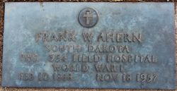
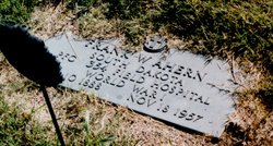
Frank William Ahern
| Birth | : | 10 Feb 1888 Howard, Miner County, South Dakota, USA |
| Death | : | 19 Nov 1957 Minnehaha County, South Dakota, USA |
| Burial | : | Saint Marys Cemetery, Salem, McCook County, USA |
| Coordinate | : | 43.7178001, -97.4096985 |
| Inscription | : | PRIVATE FIRST CLASS (PFC) - 354 FIELD HOSPITAL WORLD WAR I |
| Description | : | Frank Ahern of Salem, SD served inthe US Army Medical Unit in Germany, saw World War I end when President Woodrow Wilson signed the armistice on Armistice day at 11AM on the 11th day of the llth month in 1919. Frank then returned to Salem where he resumed his position as pharmacist along with his brother John at the Ahern Brothers Drug store located on Salem's Main Street. Frank was born on Feb 10 1888 in Howard, SD. He died Nove 18, 1957 at Sioux Falls, SD. He was laid to rest In Salem SD His parents were John... Read More |
frequently asked questions (FAQ):
-
Where is Frank William Ahern's memorial?
Frank William Ahern's memorial is located at: Saint Marys Cemetery, Salem, McCook County, USA.
-
When did Frank William Ahern death?
Frank William Ahern death on 19 Nov 1957 in Minnehaha County, South Dakota, USA
-
Where are the coordinates of the Frank William Ahern's memorial?
Latitude: 43.7178001
Longitude: -97.4096985
Family Members:
Parent
Siblings

Flowers:


Nearby Cemetories:
1. Saint Marys Cemetery
Salem, McCook County, USA
Coordinate: 43.7178001, -97.4096985
2. Wildwood Cemetery
Salem, McCook County, USA
Coordinate: 43.7178001, -97.4075012
3. Erik Olson Cemetery
Salem, McCook County, USA
Coordinate: 43.8189011, -97.4278030
4. Unityville Cemetery
McCook County, USA
Coordinate: 43.8182900, -97.4693900
5. Salem Lutheran Cemetery
Salem, McCook County, USA
Coordinate: 43.8333015, -97.3480988
6. Salem Lutheran Cemetery
Salem, McCook County, USA
Coordinate: 43.8334348, -97.3479809
7. Hillside Cemetery
Spencer, McCook County, USA
Coordinate: 43.7681007, -97.5681000
8. Sun Prairie Baptist Cemetery
Salem, McCook County, USA
Coordinate: 43.8466988, -97.4080963
9. Spencer Cemetery
Spencer, McCook County, USA
Coordinate: 43.7085991, -97.5899963
10. Immanuel Lutheran Church Cemetery
McCook County, USA
Coordinate: 43.8338100, -97.5092500
11. Pleasant Hill Cemetery
McCook County, USA
Coordinate: 43.8044014, -97.5702972
12. Lakeside Cemetery
Edgerton Township, Hanson County, USA
Coordinate: 43.7308006, -97.6138992
13. Canistota Cemetery
Canistota, McCook County, USA
Coordinate: 43.6035995, -97.2671967
14. Saint Patrick Cemetery
Montrose, McCook County, USA
Coordinate: 43.6875000, -97.1980972
15. Montrose Cemetery
Montrose, McCook County, USA
Coordinate: 43.7127991, -97.1885986
16. Saint Stephens Cemetery
Bridgewater, McCook County, USA
Coordinate: 43.5574989, -97.4766998
17. Ramsey Baptist Church Cemetery
Montrose, McCook County, USA
Coordinate: 43.8333015, -97.2410965
18. Pleasant Prairie Cemetery
Bridgewater, McCook County, USA
Coordinate: 43.5430984, -97.4496994
19. Bridgewater Cemetery
Bridgewater, McCook County, USA
Coordinate: 43.5541600, -97.5059400
20. Canova Cemetery
Canova, Miner County, USA
Coordinate: 43.8925018, -97.4888992
21. Orland Colony Cemetery
Montrose, McCook County, USA
Coordinate: 43.8189730, -97.1970890
22. Ramsey Pioneer Cemetery
McCook County, USA
Coordinate: 43.8428001, -97.2166977
23. Saint Martins Catholic Cemetery
Emery, Hanson County, USA
Coordinate: 43.6147003, -97.6271973
24. Riverside Cemetery
Canistota, McCook County, USA
Coordinate: 43.5360985, -97.3283005