
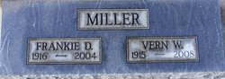
Frankie Jane Durand Miller
| Birth | : | 16 Jan 1916 Kamilche, Mason County, Washington, USA |
| Death | : | 30 Oct 2004 Olympia, Thurston County, Washington, USA |
| Burial | : | Portage Central Cemetery, Portage, Kalamazoo County, USA |
| Coordinate | : | 42.2041790, -85.5891560 |
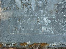
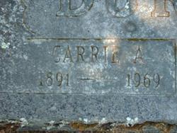
| Description | : | FRANKIE D. DURAND MILLER Frankie D. Miller , 88, died in Olympia , Oct. 30th 2004 . She was born January 17th 1916 in Kamilche, Washington to O.D. and Carrie Durand. She graduated from Shelton High School as Valedictorian of her class and went on to business school in Seattle . She and her husband bought Bettman's Men's Shop in downtown Olympia and ran it for 30 years. Frankie is survivied by her husband, Vern, daughter Shelby and son-in-law Jim Provencher, son Jeff Miller and three grandsons, Ryan, Todd and Kevin Provencher. Funeral service... Read More |
frequently asked questions (FAQ):
-
Where is Frankie Jane Durand Miller's memorial?
Frankie Jane Durand Miller's memorial is located at: Portage Central Cemetery, Portage, Kalamazoo County, USA.
-
When did Frankie Jane Durand Miller death?
Frankie Jane Durand Miller death on 30 Oct 2004 in Olympia, Thurston County, Washington, USA
-
Where are the coordinates of the Frankie Jane Durand Miller's memorial?
Latitude: 42.2041790
Longitude: -85.5891560
Family Members:
Parent
Spouse

Siblings
Flowers:


Nearby Cemetories:
1. Portage Central Cemetery
Portage, Kalamazoo County, USA
Coordinate: 42.2041790, -85.5891560
2. Pathfinder Church Memory Garden
Portage, Kalamazoo County, USA
Coordinate: 42.1877397, -85.5898254
3. West Street Cemetery
Kalamazoo, Kalamazoo County, USA
Coordinate: 42.1856030, -85.5902340
4. Dry Prairie Cemetery
Kalamazoo County, USA
Coordinate: 42.2296982, -85.6091995
5. Indian Fields Cemetery
Portage, Kalamazoo County, USA
Coordinate: 42.2305984, -85.5655975
6. South Portage Cemetery
Portage, Kalamazoo County, USA
Coordinate: 42.1668396, -85.5891418
7. Cathedral of Christ the King Resurrection Garden
Portage, Kalamazoo County, USA
Coordinate: 42.2397900, -85.6212600
8. Mount Ever-Rest Memorial Park South
Kalamazoo, Kalamazoo County, USA
Coordinate: 42.2514000, -85.5830994
9. Sand Lake Cemetery
Pavilion Township, Kalamazoo County, USA
Coordinate: 42.1660995, -85.5282974
10. Hope Cemetery
Texas Corners, Kalamazoo County, USA
Coordinate: 42.1939011, -85.6857986
11. Maple Grove Cemetery
Comstock, Kalamazoo County, USA
Coordinate: 42.2630997, -85.5299988
12. Genessee Prairie Cemetery
Oshtemo, Kalamazoo County, USA
Coordinate: 42.2585983, -85.6577988
13. Pioneer Cemetery
Kalamazoo, Kalamazoo County, USA
Coordinate: 42.2808290, -85.5893160
14. Gourdneck Prairie Cemetery
Vicksburg, Kalamazoo County, USA
Coordinate: 42.1264000, -85.5686035
15. Heritage Hall Cornerstone
Kalamazoo, Kalamazoo County, USA
Coordinate: 42.2860230, -85.5970140
16. Saint Lukes Episcopal Church Columbarium
Kalamazoo, Kalamazoo County, USA
Coordinate: 42.2883010, -85.5858860
17. Fellows Family Farm Burial Land
Schoolcraft, Kalamazoo County, USA
Coordinate: 42.1414300, -85.6661100
18. Harrison Cemetery
Schoolcraft, Kalamazoo County, USA
Coordinate: 42.1412600, -85.6664940
19. First Presbyterian Columbarium
Kalamazoo, Kalamazoo County, USA
Coordinate: 42.2896610, -85.5862750
20. Kalamazoo College Stetson Chapel
Kalamazoo, Kalamazoo County, USA
Coordinate: 42.2896000, -85.6012470
21. First United Methodist Church Columbarium
Kalamazoo, Kalamazoo County, USA
Coordinate: 42.2901990, -85.5873420
22. Schoolcraft Township Cemetery
Schoolcraft, Kalamazoo County, USA
Coordinate: 42.1225471, -85.6385117
23. Mountain Home Cemetery
Kalamazoo, Kalamazoo County, USA
Coordinate: 42.2935982, -85.6038971
24. Immanuel Lutheran Church Columbarium
Kalamazoo Township, Kalamazoo County, USA
Coordinate: 42.2961020, -85.6270529