
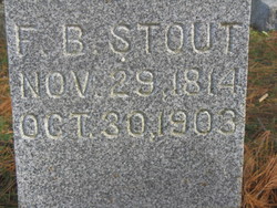


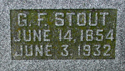
Franklin Benjamin Stout
| Birth | : | 29 Nov 1814 Brookville, Franklin County, Indiana, USA |
| Death | : | 30 Oct 1903 Steamboat Rock, Hardin County, Iowa, USA |
| Burial | : | Windy Hill Cemetery, Trappe, Talbot County, USA |
| Coordinate | : | 38.6828003, -75.9792023 |
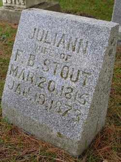
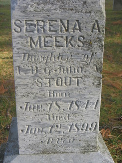
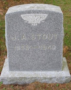
| Description | : | Franklin B. Stout, son of Jonathan and Nancy Thompson Stout, husband of Julia Ann Ewing Stout, father of Mary, Malinda, Nancy, Vina, Sarena, Jonathan, Alice, Margaret, George, and John Abner. |
frequently asked questions (FAQ):
-
Where is Franklin Benjamin Stout's memorial?
Franklin Benjamin Stout's memorial is located at: Windy Hill Cemetery, Trappe, Talbot County, USA.
-
When did Franklin Benjamin Stout death?
Franklin Benjamin Stout death on 30 Oct 1903 in Steamboat Rock, Hardin County, Iowa, USA
-
Where are the coordinates of the Franklin Benjamin Stout's memorial?
Latitude: 38.6828003
Longitude: -75.9792023
Family Members:
Spouse
Children
Flowers:


Nearby Cemetories:
1. Windy Hill Cemetery
Trappe, Talbot County, USA
Coordinate: 38.6828003, -75.9792023
2. Belmont Cemetery
Choptank, Caroline County, USA
Coordinate: 38.6828003, -75.9439011
3. Wrights Cemetery
Trappe, Talbot County, USA
Coordinate: 38.6716995, -76.0274963
4. Upper Bambury Cemetery
Trappe, Talbot County, USA
Coordinate: 38.6500015, -76.0113983
5. Landing Neck Cemetery
Trappe Landing, Talbot County, USA
Coordinate: 38.7000008, -76.0402985
6. Cheezum Family Cemetery
Preston, Caroline County, USA
Coordinate: 38.7220103, -75.9368109
7. Merrick Cemetery
Talbot County, USA
Coordinate: 38.6446991, -76.0258026
8. Mount Pleasant Cemetery
Preston, Caroline County, USA
Coordinate: 38.7202988, -75.9266968
9. Paradise Cemetery
Trappe, Talbot County, USA
Coordinate: 38.6481018, -76.0355988
10. Piney Hill Cemetery
Trappe, Talbot County, USA
Coordinate: 38.6617012, -76.0488968
11. Queen Esther Cemetery
Talbot County, USA
Coordinate: 38.7132988, -76.0456009
12. Bethesda United Methodist Church Cemetery
Preston, Caroline County, USA
Coordinate: 38.7132988, -75.9094009
13. Preston Quaker Cemetery
Preston, Caroline County, USA
Coordinate: 38.7086710, -75.9054530
14. Walter Perry Messick Farm Cemetery
Beulah, Dorchester County, USA
Coordinate: 38.6813889, -75.8978882
15. Maryland Veterans Cemetery
Hurlock, Dorchester County, USA
Coordinate: 38.6755981, -75.8983002
16. Junior Order Cemetery
Preston, Caroline County, USA
Coordinate: 38.7052994, -75.9024963
17. Fairmount Cemetery
Preston, Caroline County, USA
Coordinate: 38.7047600, -75.9013200
18. White Marsh Cemetery
Trappe, Talbot County, USA
Coordinate: 38.6970329, -76.0600662
19. Roberts Cemetery
Talbot County, USA
Coordinate: 38.7192001, -76.0488968
20. Kemp Cemetery
Trappe, Talbot County, USA
Coordinate: 38.6547012, -76.0560989
21. Old Paradise Cemetery
Trappe, Talbot County, USA
Coordinate: 38.6518390, -76.0565420
22. Mount Zion Cemetery
Bethlehem, Caroline County, USA
Coordinate: 38.7500000, -75.9430900
23. Our Lady of Good Counsel Catholic Church Cemetery
Secretary, Dorchester County, USA
Coordinate: 38.6109085, -75.9498672
24. Johns Cemetery
Preston, Caroline County, USA
Coordinate: 38.6953011, -75.8811035