
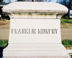


Franklin Murphy
| Birth | : | 16 Oct 1819 St. Francois County, Missouri, USA |
| Death | : | 7 Apr 1904 St. Francois County, Missouri, USA |
| Burial | : | Canton Corner Cemetery, Canton, Norfolk County, USA |
| Coordinate | : | 42.1796989, -71.1314011 |
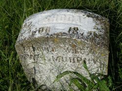
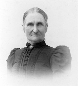
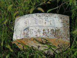
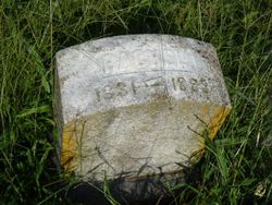
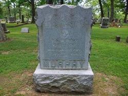
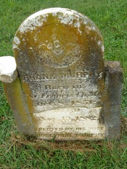
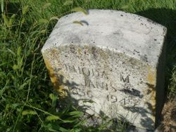
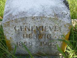
| Description | : | Buried at the Masonic Cemetery on Carter & South Henry Street in Farmington. Franklin was the son of William & Rhoda Murphy. His mother Rhoda is buried in this cemetery, his father William's final resting place is yet to be positively located. Franklin married Mary Ann Alley on Jan. 20, 1841 and had several children, listed below. Click on any of the 3 pictures for larger images of his memorial and headstones. See both of Franklin's on-line obituaries as they appeared in the newspaper in 1904 with pictures of him at the links for Mackley Genealogy obit. #1 and... Read More |
frequently asked questions (FAQ):
-
Where is Franklin Murphy's memorial?
Franklin Murphy's memorial is located at: Canton Corner Cemetery, Canton, Norfolk County, USA.
-
When did Franklin Murphy death?
Franklin Murphy death on 7 Apr 1904 in St. Francois County, Missouri, USA
-
Where are the coordinates of the Franklin Murphy's memorial?
Latitude: 42.1796989
Longitude: -71.1314011
Family Members:
Parent
Spouse
Siblings
Children
Flowers:


Nearby Cemetories:
1. Canton Corner Cemetery
Canton, Norfolk County, USA
Coordinate: 42.1796989, -71.1314011
2. St. Mary's Cemetery
Canton, Norfolk County, USA
Coordinate: 42.1764000, -71.1290700
3. Oldest Burying Ground
Canton, Norfolk County, USA
Coordinate: 42.1875500, -71.1203400
4. Gridley Cemetery
Canton, Norfolk County, USA
Coordinate: 42.1444200, -71.1483400
5. Knollwood Cemetery
Canton, Norfolk County, USA
Coordinate: 42.1463670, -71.1635760
6. Knollwood Memorial Park
Canton, Norfolk County, USA
Coordinate: 42.1478004, -71.1669006
7. Holy Sepulchre Cemetery
Stoughton, Norfolk County, USA
Coordinate: 42.1361008, -71.1053009
8. Methodist Meeting House Cemetery
Stoughton, Norfolk County, USA
Coordinate: 42.1316110, -71.1319770
9. Sharon Memorial Park
Sharon, Norfolk County, USA
Coordinate: 42.1434200, -71.1742200
10. Chestnut Tree Cemetery
Sharon, Norfolk County, USA
Coordinate: 42.1408005, -71.1753006
11. Old Parish Cemetery
Norwood, Norfolk County, USA
Coordinate: 42.1963997, -71.1988983
12. Pearl Street Cemetery
Stoughton, Norfolk County, USA
Coordinate: 42.1281013, -71.1044006
13. Maplewood Cemetery
Stoughton, Norfolk County, USA
Coordinate: 42.1366997, -71.0800018
14. Charles Sumner Bird Memorial Cemetery
Norwood, Norfolk County, USA
Coordinate: 42.1639600, -71.2082900
15. Oakland Cemetery
Randolph, Norfolk County, USA
Coordinate: 42.1838989, -71.0511017
16. Highland Cemetery
Norwood, Norfolk County, USA
Coordinate: 42.1955986, -71.2177963
17. Fairview Cemetery
Boston, Suffolk County, USA
Coordinate: 42.2454100, -71.1400200
18. Evergreen Cemetery
Stoughton, Norfolk County, USA
Coordinate: 42.1160088, -71.0987473
19. Curtis Family Cemetery
Avon, Norfolk County, USA
Coordinate: 42.1392700, -71.0569500
20. Moose Hill Cemetery
Sharon, Norfolk County, USA
Coordinate: 42.1410700, -71.2096900
21. Saint Marys Cemetery
Randolph, Norfolk County, USA
Coordinate: 42.1705560, -71.0350330
22. Rock Ridge Cemetery
Sharon, Norfolk County, USA
Coordinate: 42.1116982, -71.1663971
23. Central Cemetery
Randolph, Norfolk County, USA
Coordinate: 42.1739006, -71.0333023
24. Dry Pond Cemetery
Stoughton, Norfolk County, USA
Coordinate: 42.1045700, -71.1314900