


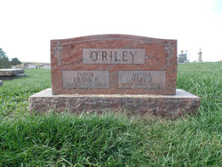
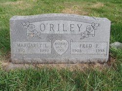
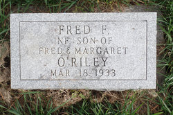
Fred Francis O'Riley
| Birth | : | 7 Dec 1908 Maryville, Nodaway County, Missouri, USA |
| Death | : | 12 Aug 1998 Maryville, Nodaway County, Missouri, USA |
| Burial | : | Kilcoy Cemetery, Kilcoy, Somerset Region, Australia |
| Coordinate | : | -26.9455258, 152.5522361 |
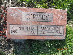
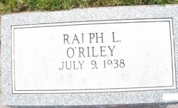
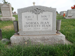
| Description | : | Fred F. O'Riley, 89, Maryville, died Wednesday, August 12, 1998, at Village Care Center, Maryville. Born December 7, 1908, in Maryville, to Frank Philip and Mary Jane Rogers O'Riley, he was a retired carpenter. He married Margaret Louise Myers, January 7, 1931, in Maryville. A lifetime resident of the Maryville area, Mr. O'Riley was a member of St. Gregory's Barbarigo Parish, Maryville, and a former member of Holy Name Society. He was preceded in death by his wife; parents; two sons, Fred F. O'Riley amd Donald E. O'Riley; a daughter, Norma J. jean; a brother, Cornelius O'Riley; and a sister, Margaret O'Riley. Survivors include five... Read More |
frequently asked questions (FAQ):
-
Where is Fred Francis O'Riley's memorial?
Fred Francis O'Riley's memorial is located at: Kilcoy Cemetery, Kilcoy, Somerset Region, Australia.
-
When did Fred Francis O'Riley death?
Fred Francis O'Riley death on 12 Aug 1998 in Maryville, Nodaway County, Missouri, USA
-
Where are the coordinates of the Fred Francis O'Riley's memorial?
Latitude: -26.9455258
Longitude: 152.5522361
Family Members:
Parent

Spouse
Siblings

Children


Flowers:


Nearby Cemetories:
1. Kilcoy Cemetery
Kilcoy, Somerset Region, Australia
Coordinate: -26.9455258, 152.5522361
2. Cressbrook Homestead Cemetery
Rochedale South, Logan City, Australia
Coordinate: -27.0603650, 152.4084090
3. Cressbrook Homestead Cemetery
Cressbrook, Somerset Region, Australia
Coordinate: -27.0578000, 152.4047000
4. Harlin General Cemetery
Harlin, Somerset Region, Australia
Coordinate: -26.9684600, 152.3536000
5. Toogoolawah Cemetery
Toogoolawah, Somerset Region, Australia
Coordinate: -27.0572990, 152.3794210
6. Caboonbah Church Cemetery
Caboonbah, Somerset Region, Australia
Coordinate: -27.1334046, 152.4675252
7. Woodford Cemetery
Woodford, Moreton Bay Region, Australia
Coordinate: -26.9458580, 152.7866720
8. Mount Mee Cemetery
Mount Mee, Moreton Bay Region, Australia
Coordinate: -27.0586281, 152.7549438
9. Moore-Linville Cemetery
Moore, Somerset Region, Australia
Coordinate: -26.8773340, 152.2965680
10. Fairview Cemetery
Bryden, Somerset Region, Australia
Coordinate: -27.2057004, 152.5536795
11. Bryden Catholic Cemetery
Bryden, Somerset Region, Australia
Coordinate: -27.2426026, 152.5698927
12. Peachester Cemetery
Crohamhurst, Sunshine Coast Council, Australia
Coordinate: -26.8199922, 152.8714523
13. Esk Cemetery
Esk, Somerset Region, Australia
Coordinate: -27.2394293, 152.4163463
14. Grigor Children
Glass House Mountains, Sunshine Coast Council, Australia
Coordinate: -26.9166600, 152.9228750
15. Dayboro Cemetery
Dayboro, Moreton Bay Region, Australia
Coordinate: -27.1912910, 152.8129120
16. Witta Cemetery
Witta, Sunshine Coast Council, Australia
Coordinate: -26.7061560, 152.8270080
17. Upper Caboolture Uniting Church Cemetery
Upper Caboolture, Moreton Bay Region, Australia
Coordinate: -27.1071200, 152.8945300
18. Beerburrum Cemetery
Beerburrum, Sunshine Coast Council, Australia
Coordinate: -26.9490050, 152.9547500
19. Caboolture Cemetery
Caboolture, Moreton Bay Region, Australia
Coordinate: -27.0856520, 152.9397800
20. Australia Zoo
Beerwah, Sunshine Coast Council, Australia
Coordinate: -26.8361140, 152.9615310
21. Blackbutt-Benarkin Cemetery
Blackbutt, South Burnett Region, Australia
Coordinate: -26.8877200, 152.1261340
22. St Mary's Church
Montville, Sunshine Coast Council, Australia
Coordinate: -26.6879465, 152.8926176
23. Beerwah Cemetery
Beerwah, Sunshine Coast Council, Australia
Coordinate: -26.8521020, 152.9875450
24. Flaxton Cemetery
Flaxton, Sunshine Coast Council, Australia
Coordinate: -26.6617420, 152.8731570