
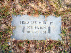
Fred Lee Murphy
| Birth | : | 26 Oct 1892 Bowman, Orangeburg County, South Carolina, USA |
| Death | : | 24 Dec 1954 Orangeburg, Orangeburg County, South Carolina, USA |
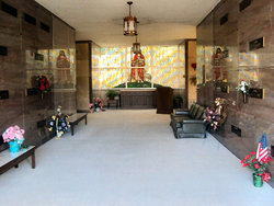
| Burial | : | Nichols Point Cemetery, Nichols Point, Mildura Rural City, Australia |
| Coordinate | : | -34.1931500, 142.2173320 |
| Description | : | Orangeburg, Dec. 22 - Fred L. Murphy, 62, of Orangeburg, died Tuesday night at the Orangeburg Regional Hospital after an illness of six months. Mr. Murphy was born near Bowman, son of the late Jack Lee Murphy and Cora Hungerpiller Murphy. He was a member of the Walnut Grove Baptist Church. Funeral services will be held at 11 a.m. Friday at the Dukes-Harley Funeral Chapel, conducted by the Rev. J. M. Lane, assisted by the Rev. Fred T. Laughon Jr. Burial will be in Memorial Park Cemetery. Survivors include: three daughters, Mrs. Bill Bolen of Orangeburg; Mrs.... Read More |
frequently asked questions (FAQ):
-
Where is Fred Lee Murphy's memorial?
Fred Lee Murphy's memorial is located at: Nichols Point Cemetery, Nichols Point, Mildura Rural City, Australia.
-
When did Fred Lee Murphy death?
Fred Lee Murphy death on 24 Dec 1954 in Orangeburg, Orangeburg County, South Carolina, USA
-
Where are the coordinates of the Fred Lee Murphy's memorial?
Latitude: -34.1931500
Longitude: 142.2173320
Family Members:
Parent

Spouse

Siblings

Children

Flowers:


Nearby Cemetories:
1. Mildura Homestead Cemetery
Mildura, Mildura Rural City, Australia
Coordinate: -34.1723600, 142.1588210
2. Murray Pines Cemetery
Mildura, Mildura Rural City, Australia
Coordinate: -34.2397472, 142.0914611
3. Red Cliffs Pioneer Cemetery
Red Cliffs, Mildura Rural City, Australia
Coordinate: -34.3326360, 142.1628590
4. Red Cliffs Lawn Cemetery
Red Cliffs, Mildura Rural City, Australia
Coordinate: -34.3326317, 142.1616211
5. Merbein Cemetery
Merbein, Mildura Rural City, Australia
Coordinate: -34.1491670, 142.0427420
6. Carwarp Cemetery
Carwarp, Mildura Rural City, Australia
Coordinate: -34.4396770, 142.2204700
7. Werrimull Cemetery
Werrimull, Mildura Rural City, Australia
Coordinate: -34.3988800, 141.5960490
8. Euston Cemetery
Euston, Balranald Shire, Australia
Coordinate: -34.5853110, 142.7372226
9. Robinvale Cemetery
Swan Hill, Swan Hill Rural City, Australia
Coordinate: -34.6067920, 142.7944610
10. Bannerton Cemetery
Bannerton, Swan Hill Rural City, Australia
Coordinate: -34.7103270, 142.7874560
11. Meringur Cemetery
Mildura, Mildura Rural City, Australia
Coordinate: -34.3714000, 141.3343000
12. Ouyen Cemetery
Ouyen, Mildura Rural City, Australia
Coordinate: -35.0918230, 142.3246260
13. Walpeup Cemetery
Walpeup, Mildura Rural City, Australia
Coordinate: -35.1350920, 142.0304330
14. Manangatang Cemetery
Manangatang, Swan Hill Rural City, Australia
Coordinate: -35.0250750, 142.8706550
15. Underbool Cemetery
Underbool, Mildura Rural City, Australia
Coordinate: -35.1799370, 141.8096670
16. Boinka Cemetery
Mildura Rural City, Australia
Coordinate: -35.1938800, 141.5960580
17. Chinkapook Cemetery
Chinkapook, Swan Hill Rural City, Australia
Coordinate: -35.1841600, 142.9448900
18. Wyrama Old Cuthero Cemetery
Menindee, Central Darling Shire, Australia
Coordinate: -33.0287900, 142.3512900
19. Nandaly Cemetery
Nandaly, Buloke Shire, Australia
Coordinate: -35.3092938, 142.7106171
20. Paringa Cemetery
Paringa, Renmark Paringa Council, Australia
Coordinate: -34.1628170, 140.7821640
21. Stoeckel Family Cemetery
Paringa, Renmark Paringa Council, Australia
Coordinate: -34.1785780, 140.7803160
22. Tutye Cemetery
Tutye, Mildura Rural City, Australia
Coordinate: -35.2130720, 141.4741200
23. Balranald Cemetery
Balranald, Balranald Shire, Australia
Coordinate: -34.6285610, 143.5645820
24. Bugle Hut Lutheran Cemetery
Loxton, District Council of Loxton Waikerie, Australia
Coordinate: -34.3607730, 140.7801570