
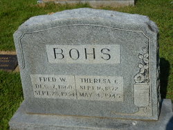
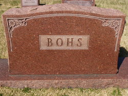
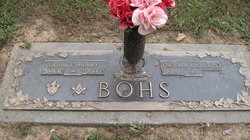
Frederick William Bohs
| Birth | : | 7 Dec 1860 Iron Mountain, St. Francois County, Missouri, USA |
| Death | : | 28 Sep 1934 Farmington, St. Francois County, Missouri, USA |
| Burial | : | Washington Township Cemetery, Duncombe, Webster County, USA |
| Coordinate | : | 42.4707900, -94.0002000 |
| Description | : | Husband of Theresa Katherine Zimmer Son of John Bohs & Marie Hennrich |
frequently asked questions (FAQ):
-
Where is Frederick William Bohs's memorial?
Frederick William Bohs's memorial is located at: Washington Township Cemetery, Duncombe, Webster County, USA.
-
When did Frederick William Bohs death?
Frederick William Bohs death on 28 Sep 1934 in Farmington, St. Francois County, Missouri, USA
-
Where are the coordinates of the Frederick William Bohs's memorial?
Latitude: 42.4707900
Longitude: -94.0002000
Family Members:
Spouse

Children

Flowers:


Nearby Cemetories:
1. Washington Township Cemetery
Duncombe, Webster County, USA
Coordinate: 42.4707900, -94.0002000
2. Saint Josephs Cemetery
Duncombe, Webster County, USA
Coordinate: 42.4789009, -93.9922028
3. Washington Cemetery
Duncombe, Webster County, USA
Coordinate: 42.4277992, -93.9916992
4. Colfax Cemetery
Webster County, USA
Coordinate: 42.5224991, -94.0194016
5. Blanchard Cemetery
Webster County, USA
Coordinate: 42.4021988, -93.9997025
6. Holaday Creek Cemetery
Webster County, USA
Coordinate: 42.4472008, -94.0886002
7. Border Plains Cemetery
Border Plains, Webster County, USA
Coordinate: 42.3917000, -94.0448000
8. Ober and Scott Cemetery
Duncombe, Webster County, USA
Coordinate: 42.3841390, -93.9982856
9. Hartman Cemetery
Lehigh, Webster County, USA
Coordinate: 42.3666397, -93.9835627
10. Otho Cemetery
Otho, Webster County, USA
Coordinate: 42.4025002, -94.1153030
11. Fort Dodge Memorial Park
Fort Dodge, Webster County, USA
Coordinate: 42.5032997, -94.1472015
12. West Lawn Cemetery
Lehigh, Webster County, USA
Coordinate: 42.3616982, -94.0678024
13. Homer Cemetery
Homer, Hamilton County, USA
Coordinate: 42.3680992, -93.9088974
14. Community Church Cemetery
Kamrar, Hamilton County, USA
Coordinate: 42.4556000, -93.8342000
15. Calvary Cemetery
Webster City, Hamilton County, USA
Coordinate: 42.4556007, -93.8341980
16. Graceland Cemetery
Webster City, Hamilton County, USA
Coordinate: 42.4578018, -93.8308029
17. Teters Family Cemetery
Vincent, Webster County, USA
Coordinate: 42.6005700, -94.0034200
18. McGuire Bend Cemetery
Dayton, Webster County, USA
Coordinate: 42.3410000, -93.9880000
19. Oak Grove Cemetery
Lehigh, Webster County, USA
Coordinate: 42.3438988, -94.0475006
20. Newark Township Cemetery
Vincent, Webster County, USA
Coordinate: 42.6021996, -94.0408020
21. Trails End Cemetery
Webster City, Hamilton County, USA
Coordinate: 42.4587810, -93.8128710
22. Oakland Cemetery
Fort Dodge, Webster County, USA
Coordinate: 42.5214005, -94.1800003
23. Corpus Christi Cemetery
Fort Dodge, Webster County, USA
Coordinate: 42.5243988, -94.1802979
24. North Lawn Cemetery
Fort Dodge, Webster County, USA
Coordinate: 42.5290000, -94.1778000